
Sehlde
| coat of arms | Germany map | |
|---|---|---|

|
Coordinates: 52 ° 2 ′ N , 10 ° 16 ′ E |
|
| Basic data | ||
| State : | Lower Saxony | |
| County : | Wolfenbüttel | |
| Joint municipality : | Baddeckestedt | |
| Height : | 135 m above sea level NHN | |
| Area : | 20.38 km 2 | |
| Residents: | 890 (Dec. 31, 2019) | |
| Population density : | 44 inhabitants per km 2 | |
| Postal code : | 38279 | |
| Area code : | 05341 | |
| License plate : | WF | |
| Community key : | 03 1 58 028 | |
| Association administration address: | Heerer Strasse 28 38271 Baddeckestedt |
|
| Mayor : | Reinhard Päsler ( SPD ) | |
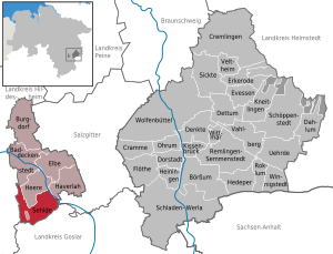
| Location of the municipality of Sehlde in the Wolfenbüttel district | ||
  |
||


Sehlde is a municipality in the district of Wolfenbüttel in Lower Saxony ( Germany ). It is located in the south-west of the combined community of Baddeckestedt , which has its administrative headquarters in Baddeckestedt .
Geographical location
Sehlde is located at the eastern foot of the Hainberg ridge (max. 299 m above sea level ) on the Innerste , into which the Neile flows 900 m southeast of the outskirts . Neighboring municipalities and cities are Baddeckestedt and Heere in the north-northwest and Haverlah in the east-northeast (all in the Wolfenbüttel district), Wallmoden in the south-southeast (in the Goslar district ) and Bockenem in the west-southwest and Holle in the northwest (both in the Hildesheim district ).
history
The first written mention of the place can be found in the deed of foundation of the Ringelheim monastery from 941, in which among the possessions of the monastery also those in selida (as the place was called at the time) are listed. The names of the place mentioned in the traditions vary little, until the 13th century it was mostly called selede or selethe . The similar today's spelling Seelde is found for the first time in 1374, since the 17th century is Sehlde common.
In a document from 1209, a distinction is made for the first time between the places maiore selede (Groß Sehlde) and minore selede (Klein Sehlde). Klein Sehlde was about a kilometer southeast of today's Sehlde. From the 16th century, however, the distinction between Groß- and Klein Sehlde is no longer listed, and the two places were probably merged.
In addition to the Ringelheim monastery, the landowners in the village also included the Hildesheim diocese and the Riechenberg and Neuwerk monasteries as well as the Simonis and Judae monastery near Goslar .
Since the division of East Westphalia into Gaue , introduced by Charlemagne , Sehlde belonged to the Ambergau within the Duchy of Hildesheim , the seat of the Gau was Bockenem . At the beginning of the 14th century, offices were formed from the previous castle districts and Sehlde has belonged to the Wohldenberg office since 1313 . After the end of the Hildesheim collegiate feud in 1523, a large part of the Hildesheim diocese was awarded to the Duchy of Braunschweig . It was not until 1643 that this judgment was revised in the Hildesheim main recession and the diocese got its possessions back.
Sehlde became Prussian in 1802 when the Hildesheim Monastery was incorporated into the Kingdom of Prussia . In the Napoleonic period from 1807 to 1813, Sehlde belonged as a commune in the canton of Holle in the Goslar district in the Oker department of the Kingdom of Westphalia . With the reorganization of the Prussian land order, the district of Marienburg was formed in 1885 , to which Sehlde belonged from now on. In 1941, Sehlde was assigned to the Wolfenbüttel district together with nine other municipalities as part of the "Ordinance on territorial clearances in the area of the Reichswerke Hermann Göring " and has been part of the Baddeckestedt municipality since 1974.
religion
The current building of the church of Sehlde was built at the end of the 17th century. This is attested by several inscriptions, such as the year 1696 on the tower of the church and on the main wooden cornice. On the south side of the tower you can read “M. HANS BRVNKEN ANNO 1698 ”and the year 1702 is given in an inscription on the south-east wall of the nave. On the north side, the inscription "RENOVATUM 1840" announces renovation work this year. The baroque altar from 1749, which is attributed to the Hildesheim woodcarver Ernst Dietrich Bartels (1679 to 1762), is remarkable .
In the Duchy of Braunschweig , to which Sehlde belonged at the time, the Reformation was introduced in 1568 by Duke Julius (1568–1589) . Today (2013) the church of Sehlde, together with parishes of large and small armies, forms a parish association that belongs to the Goslar provost.
The closest Catholic parish is in Salzgitter-Ringelheim .
politics

Municipal council
The municipal council of Sehlde consists of nine councilors (change from 2011).
(Status: local election on September 11, 2016 )
mayor
The honorary mayor Reinhard Päsler (SPD) was elected on October 6, 1996.
coat of arms
Blazon : "In green, a silver stag with a floating silver cross between the antlers." The coat of arms goes back to the Hubertus legend , which in this case is said to have occurred in the chapel at the Jägerhaus. Then a wild hunter was converted when he saw a white stag with a brilliant crucifix between the antlers while hunting on Good Friday. Alfred Hesse created the design for the coat of arms; the coat of arms was approved by the Interior Minister of Lower Saxony in 1953.
Culture and sights
About 3.5 kilometers west-southwest of Sehlde in the Hainberg are the Hubertus chapel ( Hubertus grotto ) and the Jägerhaus .
- The Hubertuskapelle is a rock chapel carved into the Hilssandstone , which the Drost (magistrate) von Wohldenberg, Friedrich Anton Freiherr von Bocholtz, had built in 1733. The chapel room is 2.60 m high, 2.90 m long and 2.60 m wide. On its long sides there are two opposite entrances: the northern one with a 12 m long staircase carved into the rock comes from the plateau of the hunter's house, and the southern one is just a breakthrough in the outer wall of the chapel. A relief depicting the legend of Hubertus is carved into the rear wall of the interior of the chapel. The chapel became a place of consecration for the hunters who hold a service here every year on November 3rd, Hubertus Day. There is a refuge by the chapel.
- A little north of the Hubertus Chapel, Count Ernst Friedrich Herbert zu Münster , who owned the nearby Derneburg Castle , had the Jägerhaus built around 1838, which was used as a forest restaurant until 2013. In April 2018 the restaurant was still closed.

Jägerhaus near Sehlde

Hubertus chapel at the Jägerhaus

Relief on the Hubertus chapel

.JPG)
.JPG)
Economy and Infrastructure
The Braunschweig – Kreiensen railway runs through the municipality . The nearest train station is the Salzgitter-Ringelheim train station located about four kilometers east of the center of Sehlde, where the aforementioned route crosses with the Hildesheim-Goslar railway line .
literature
- Hans-Heinrich Scholz: Sehlde an der Innerste: Description of a Lower Saxony village . Ed .: Municipality of Sehlde. Oppermann printing works, Hildesheim 1990.
- Ernst Andreas Friedrich : The Hubertus Chapel in Hainberg , pp. 92–95, in: If stones could talk. Volume I, Landbuch-Verlag, Hannover 1989, ISBN 3-7842-0397-3 .
Web links
- Samtgemeinde Baddeckestedt , on baddeckestedt.de
- Jägerhaus and Hubertus Chapel in the Hainberge. www.no-mads.de, accessed on April 24, 2018 .
References and comments
- ↑ State Office for Statistics Lower Saxony, LSN-Online regional database, Table 12411: Update of the population, as of December 31, 2019 ( help ).
- ↑ Map services of the Federal Agency for Nature Conservation ( information )
- ↑ In the municipality of Sehlde, in the Hainberg ridge on the eastern slope of the Steinberg, there is an exclave of the municipality of Heere .
- ↑ Kirstin Casemir: The place names of the district Wolfenbüttel and the city of Salzgitter (= Lower Saxony place name book . Volume 3 ). Verlag für Regionalgeschichte, 2003, ISBN 3-89534-483-4 , p. 293–295 (At the same time: Diss. University of Göttingen, 2002).
- ^ Website of the municipal services Oldenburg , accessed on September 13, 2016.
- ^ Arnold Rabbow: New Braunschweigisches Wappenbuch . Braunschweiger Zeitungsverlag, 2003, ISBN 3-926701-59-5 , p. 170 .
- ↑ The Hubertus Chapel in Hainberg (Höhlengruppe Nord e. V .; HGN), accessed on January 25, 2016, from hgnord.de.
- ↑ Alexander Raths: The Jägerhaus wants to reopen in summer 2017. www.hildesheimer-allgemeine.de, September 20, 2016, accessed on April 24, 2018 .
- ^ Erik Westermann: Construction work is in progress on the Jägerhaus - surrounding area - Salzgitter newspaper. www.salzgitter-zeitung.de, July 29, 2016, accessed on April 24, 2018 .
Baddeckestedt | Stock exchange | Burgdorf | Cramme | Cremlingen | Dahlum | Thought | Dettum | Dorstadt | Elbe | Bay window | Evessen | Flute | Haverlah | Hedeper | Armies | Heiningen | Pillow bridge | Kneitlingen | Ohrum | Remlingen-Semmenstedt | Roklum | Schladen-Werla | Schöppenstedt | Sehlde | Sicken | Uehrde | Vahlberg | Veltheim (Ohe) | Winnigstedt | Wittmar | Wolfenbüttel
Unregulated areas in the district of Wolfenbüttel
Am Großen Rhode |
Barnstorf-Warle |
Voigtsdahlum