
Hedeper
| coat of arms | Germany map | |
|---|---|---|

|
Coordinates: 52 ° 4 ′ N , 10 ° 41 ′ E |
|
| Basic data | ||
| State : | Lower Saxony | |
| County : | Wolfenbüttel | |
| Joint municipality : | Elm aces | |
| Height : | 94 m above sea level NHN | |
| Area : | 15.66 km 2 | |
| Residents: | 492 (Dec. 31, 2019) | |
| Population density : | 31 inhabitants per km 2 | |
| Postal code : | 38322 | |
| Area code : | 05336 | |
| License plate : | WF | |
| Community key : | 03 1 58 017 | |
| Community structure: | 2 districts | |
| Association administration address: | Markt 3 38170 Schöppenstedt |
|
| Website : | ||
| Mayor : | Andreas Bötel (UWG) | |
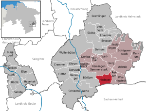
| Location of the municipality of Hedeper in the Wolfenbüttel district | ||
  |
||

Hedeper is a municipality in the Harz foreland in eastern Lower Saxony with around 500 inhabitants in the Wolfenbüttel district on around 16 km² . It belongs to the joint municipality of Elm-Asse , which has its administrative headquarters in the city of Schöppenstedt .
geography
location
The place is west of the Great Break . The district town of Wolfenbüttel is about 15 km (as the crow flies) northwest of Hedeper. In the southeast is the " Klotzberg ", the smallest but first nature reserve in the district.
Community structure
The municipality of Hedeper consists of two districts (population on December 1, 2016) :
- Hedeper (379 inhabitants).
- Wetzleben (120 inhabitants)
history
middle Ages
The villages of Wetzleben and Hedeper were first mentioned in a document very early, Hedeper in 1188 and Wetzleben as early as 994.
In the High Middle Ages, several hooves from the possession of Count Konrad II von Wassel were inherited by the Counts of Hallermund . The Count of Hallermund sold six hooves in Hedeper to the Wöltingerode monastery in 1212 , after the Lord von Wöltingerode had equipped the monastery with two and a half hooves in Hedeper in 1188. With the consent of the Counts of Hallermund as feudal lords, a hoof land in Hedeper was sold to the Marienberg monastery (Helmstedt) in 1242 . The Counts of Dassel were also wealthy in the village due to their relationship with Adelheid von Wassel . In 1268 they sold a hoof to the Riddagshausen monastery . A manse in Hedeper, for which Count Simon von Dassel was feudal lord, was sold in 1305 to the Marienhospital in Braunschweig .
In 1696 the Riddagshausen Monastery still owned two Meierhöfe with six hooves each.
Modern times
Hedeper station was on the Jerxheim – Börßum railway line . The village center was destroyed in 1983 through the creation of a dead straight through town.
Place name
The prefix Hed- probably comes from the old Germanic hað- "inclination, bend", which probably means "located on a slope". Similar prefixes can be found for Hebborn and Hedemünden on a slope / hill .
The suffix -per (or -ber) comes from the old Germanic bearo "Hain, Wald", as in other places in the region: Iber , Heudeber and Reddeber .
Overall, “Hedeper” would mean “little wood on the hill”, and Hedeper is actually one of the highest places in the municipality.
Incorporations
On March 1, 1974, the community of Wetzleben was incorporated.
Municipal council
The municipal council, which was elected on September 10, 2006, was composed as follows:
On November 1, 2011 the electoral period of the new municipal council elected on September 11, 2011 began:
- UWG 5 seats
- SPD 4 seats
economy
The inhabitants of Hedeper lived mainly from agriculture and forestry. Even if the place is still dominated by agriculture today, the jobs of the residents are mainly in Wolfenbüttel, Braunschweig, Salzgitter or Wolfsburg.
Culture and sights

Mills
The symbol of the village of Hedeper is the Erdholländer windmill on the western edge , which is a station on the Lower Saxony Mill Road . It was built in 1900 and was in operation until 1956. 20 windmills used to be visible from here. Today there are numerous wind turbines in the area .
church

The nave was added to a medieval previously secular tower in 1798, which was torn down between 1994 and 1996. Due to the unstable subsoil, there was a risk of collapse. Using the recyclable material, the new, somewhat smaller St. Martin Church was reconstructed according to the plans of the old nave before 1789 and consecrated in 1997 . The parish Hedeper belongs to the Evangelical Lutheran regional church in Braunschweig .
Individual evidence
- ↑ State Office for Statistics Lower Saxony, LSN-Online regional database, Table 12411: Update of the population, as of December 31, 2019 ( help ).
- ↑ Julius Grote: The Counts of Wassel, Vicedomini von Hildesheim, in: Journal of the Historical Association for Lower Saxony, 1856, p. 241
- ↑ Wolfgang Petke: The Counts of Wöltingerode-Wohldenberg, 1971, p. 18
- ^ Yearbooks of the Association for Meklenburg History and Archeology, 1838, p. 31.
- ↑ von Arnstedt: About the origin of the Magdeburg Archbishops, in: Geschichtsblätter für Stadt und Land Magdeburg, 1870, p. 52
- ^ The architectural and art monuments of the Duchy of Braunschweig, Volume 2, 1900, p. 124.
- ↑ Manfred Sack: With Karacho through the village. In: THE TIME. October 1983. (online p. 43ff.) ( Memento of the original dated August 10, 2014 in the Internet Archive ) Info: The archive link was inserted automatically and has not yet been checked. Please check the original and archive link according to the instructions and then remove this notice. (PDF; 6.1 MB)
- ↑ Article in: Reallexikon der Germanischen Altertumskunde
- ^ Name studies on the German problem by Jürgen Udolph
- ^ Federal Statistical Office (ed.): Historical municipality directory for the Federal Republic of Germany. Name, border and key number changes in municipalities, counties and administrative districts from May 27, 1970 to December 31, 1982 . W. Kohlhammer GmbH, Stuttgart / Mainz 1983, ISBN 3-17-003263-1 , p. 273 .
- ↑ Election results - municipal council election Hedeper 11.09.2011 ( Memento of the original from April 6, 2013 in the Internet Archive ) Info: The archive link has been inserted automatically and has not yet been checked. Please check the original and archive link according to the instructions and then remove this notice.
- ^ Historical Association for Lower Saxony: Sources and representations on the history of Lower Saxony. 1965, vol. 64/65, p. 167.
- ↑ Parish Hedeper ( Memento of the original from August 10, 2014 in the Internet Archive ) Info: The archive link was inserted automatically and has not yet been checked. Please check the original and archive link according to the instructions and then remove this notice.
- ↑ Medio Via: "On Good Ground" - The Reconstruction of a Church
Web links
- Elm-Asse municipality
- Hedeper 1983: Building demolition for road construction. (PDF; 6.1 MB) In: Jürgen Kumlehn: Reminder and memorandum on the discussion about the demolition of the Hertie department store in Wolfenbüttel's old town. 2009, p. 20.
Baddeckestedt | Stock exchange | Burgdorf | Cramme | Cremlingen | Dahlum | Thought | Dettum | Dorstadt | Elbe | Bay window | Evessen | Flute | Haverlah | Hedeper | Armies | Heiningen | Pillow bridge | Kneitlingen | Ohrum | Remlingen-Semmenstedt | Roklum | Schladen-Werla | Schöppenstedt | Sehlde | Sicken | Uehrde | Vahlberg | Veltheim (Ohe) | Winnigstedt | Wittmar | Wolfenbüttel
Unregulated areas in the district of Wolfenbüttel
Am Großen Rhode |
Barnstorf-Warle |
Voigtsdahlum