
Veltheim (Ohe)
| coat of arms | Germany map | |
|---|---|---|
.png)
|
Coordinates: 52 ° 13 ' N , 10 ° 41' E |
|
| Basic data | ||
| State : | Lower Saxony | |
| County : | Wolfenbüttel | |
| Joint municipality : | Sank | |
| Height : | 130 m above sea level NHN | |
| Area : | 8.44 km 2 | |
| Residents: | 985 (Dec. 31, 2019) | |
| Population density : | 117 inhabitants per km 2 | |
| Postal code : | 38173 | |
| Area code : | 05305 | |
| License plate : | WF | |
| Community key : | 03 1 58 033 | |
| Association administration address: | Am Kamp 12 38173 Sickte |
|
| Mayor : | Alexander von Veltheim ( CDU ) | |
| Location of the municipality of Veltheim (Ohe) in the Wolfenbüttel district | ||
 _in_WF.svg) |
||

.jpg)

Veltheim (Ohe) is a place and a municipality in the district of Wolfenbüttel in Lower Saxony . In addition to Veltheim, the town of Klein Veltheim also belongs to the community. The municipality of Veltheim is a member of the Samtgemeinde Sickte .
geography
Veltheim is located on the western foothills of the Elm in the fertile loess area of the East Brunswick hill country . Several brooks flow together from the Elmrand, one of which is Ohe . The forest area north of Klein Veltheim has the same name and is connected to the Veltheim Forest to the east.
The place is now off the road connecting Sickte and Lucklum , the state road L 625, which runs south of the honeycomb . The honeycomb drove several mills in earlier times.
history
The village name Veltheim, formerly also Veltem or Veltum, means home in the field . However, there are also indications that the Wolfenbütteler Veltheim dates from the Franconian period between 500 and 900 AD, when the Franks established church villages at strategically favorable points during Christianization .
Castle and manor
The current owners of the estate, the von Veltheim family , are first mentioned in a document in 1160. They built the Veltheim moated castle, which was later transformed into Veltheim Castle . Around 1494 the destroyed castle was sold to the von Honrodt family. In 1537 Ernst von Honrodt was enfeoffed by Brunswick Duke Heinrich the Younger with the castle, the court, the church patronage and the forests. In 1555 he redesigned the moated castle into a palace. In 1832 the Veltheim family bought back their ancestral estate. Today the farmer and landowner Alexander von Veltheim is mayor of the community. The Veltheim family has been a church patron in Veltheim for over 400 years .
The Cuntercamp is on the way to the castle. A grave slab in the church commemorates the death of the Junkers Hans and Christoph von Honrodt in 1531 on the day of Ascension . These are said to have quarreled over a peasant girl until both remained in their blood . The massive walls of the Veltheimer Wasserburg are also the cause of numerous legends that speak of "evil spirits".
religion
The historic church of St. Remigius is located on Kirchstrasse, its parish belongs to the Evangelical Lutheran provost of Königslutter.
The Catholic Church Heilig Kreuz is located on the waterway, it was built in 1949 by Josef Fehlig and is today the oldest post-war church in the Diocese of Hildesheim that is still in operation. Your parish, which has also included the Catholic Church in Weddel since 2006 , is part of the Braunschweig deanery .
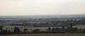
View of Veltheim (Ohe) from the east
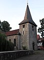
Evangelical village church

Catholic Church


politics
The municipal council, which was elected on September 11, 2011, is composed as follows:
(As of: local election on September 11, 2011)

Culture and sights
- A specialty of Veltheim are the two sinkholes in the Feldmark , in which spring ponds have formed. A sinkhole formed on September 7, 1949. According to a legend, Napoleon is said to have hidden a gold treasure on the historic road between Braunschweig and Magdeburg or on the course of the Ohe stream.
- Lake Veronika is located a little north of Veltheim (Ohe) in the Ohe forest . It was formed in 1972 when the Ohe brook was dammed and is just under two hectares in size. On the western edge of the lake is the former mill pond of the Veltheimer Mühle.
Personalities
- Wilhelm Hille (1803–1880), German Lutheran theologian and Abbot of Amelungsborn
literature
- Hans-Adolf Schultz : Castles and palaces of the Braunschweiger Land , Braunschweig 1980, ISBN 3-87884-012-8
- Ernst Andreas Friedrich : Das Schloß Veltheim , pp. 131–132, in: If stones could talk. Volume IV, Landbuch-Verlag, Hannover 1998, ISBN 3-7842-0558-5
- Herbert Wolff: Veltheim (Ohe) 1160-2010 - Ortschronik for the 850 year celebration 2010 , Veltheim (Ohe) 2010
Web links
Individual evidence
- ↑ State Office for Statistics Lower Saxony, LSN-Online regional database, Table 12411: Update of the population, as of December 31, 2019 ( help ).
Baddeckestedt | Stock exchange | Burgdorf | Cramme | Cremlingen | Dahlum | Thought | Dettum | Dorstadt | Elbe | Bay window | Evessen | Flute | Haverlah | Hedeper | Armies | Heiningen | Pillow bridge | Kneitlingen | Ohrum | Remlingen-Semmenstedt | Roklum | Schladen-Werla | Schöppenstedt | Sehlde | Sicken | Uehrde | Vahlberg | Veltheim (Ohe) | Winnigstedt | Wittmar | Wolfenbüttel
Unregulated areas in the district of Wolfenbüttel
Am Großen Rhode |
Barnstorf-Warle |
Voigtsdahlum