Dorstadt
| coat of arms | Germany map | |
|---|---|---|

|
Coordinates: 52 ° 6 ′ N , 10 ° 34 ′ E |
|
| Basic data | ||
| State : | Lower Saxony | |
| County : | Wolfenbüttel | |
| Joint municipality : | Oderwald | |
| Height : | 80 m above sea level NHN | |
| Area : | 30.6 km 2 | |
| Residents: | 2784 (Dec. 31, 2019) | |
| Population density : | 91 inhabitants per km 2 | |
| Postal code : | 38312 | |
| Area code : | 05337 | |
| License plate : | WF | |
| Community key : | 03 1 58 038 | |
| Address of the municipal administration: |
Bahnhofstrasse 6 38312 Börßum |
|
| Website : | ||
| Mayor : | Bruno Polzin ( SPD ) | |
| Location of the municipality of Dorstadt in the Wolfenbüttel district | ||
Dorstadt is a municipality of the Oderwald municipality (seat in Börßum ) in the Wolfenbüttel district in Lower Saxony ( Germany ).
geography
Dorstadt is located between Wolfenbüttel and Schladen on the eastern slope of the Oderwald directly on the Oker , naturally in the Börßum-Braunschweiger Okertal . This is formed by the Oker, the earlier course of the Ilse and the Warne flowing into the Oker in Dorstadt . On the right bank, several elevations such as the Westerberg and the Spitzberg form the rather forestless landscape. Two kilometers north, on the left bank, is Ohrum with the historic Oker crossing and a few kilometers south of Heiningen and on the right of the Oker the former Börßum railway junction .
history
Dorstadt was first mentioned in 1110. Eiko von Dorstadt, who had his ancestral seat in today's Dorstadt, received the episcopal castle Schladen from Bishop Udo von Hildesheim. In 1167 the community was mentioned in a document as Neuendorf .
The history of the place was linked to that of the Dorstadt monastery for 600 years . In 1189 the Augustinian women's choir of the Holy Cross was donated by the noblemen in front of Dorstadt. The monastery continuously increased its property by buying land in the neighboring villages, up to Bruchmachtersen in the 13th century the monastery property increased to 1000 hectares of fields. After a “Protestant interim phase” from 1568, the Augustinians returned in 1643.
The monastery was secularized in 1802. In 1810 the monastery was sold as a manor.
religion
- Evangelical Lutheran St. Bartholomew Church (Am Bruch 10). The historic church belongs to the Halchter parish association and is the southernmost church of the Wolfenbüttel provost .
- Catholic Holy Cross Church (Harzstrasse 49). Built in 1937 and expanded in 1964, since 2006 a branch church of the parish of St. Petrus in Wolfenbüttel . The house of reflection is located at the church , it is a self-catering house sponsored by the parish of St. Petrus and is used by groups of up to 20 people for days of reflection, training and leisure time.
- New Apostolic Church (Am Förstergarten 8). The church services of the congregation, which was founded in 1957, initially took place in the old school in the southern village, and in 1977 their own church was built. The community belongs to the church district Wolfenbüttel.
politics
The local council from Dorstadt consists of 9 councilors.
(Status: 2011 local elections)
After the local elections in 2016, the distribution of seats remained unchanged.
Mayor is Bruno Polzin (SPD).
coat of arms
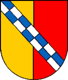
Blazon : "Gold-red split and covered diagonally right with a blue-silver chess bar."
Manor house (former Dorstadt monastery )
Economy and Infrastructure
The Dorstadt manor is today operated as an agricultural company with agriculture, forestry and building management.
The federal motorway 36 with the connection in Klein Flöthe is about 6 km west of the community. Dorstadt is also on the Braunschweig – Bad Harzburg railway line .
Personalities
Born in Dorstadt
- Eberhard Warkehr (1932–2017), German chemist, university professor, university rector and local politician
Web links
Individual evidence
- ↑ State Office for Statistics Lower Saxony, LSN-Online regional database, Table 12411: Update of the population, as of December 31, 2019 ( help ).
- ↑ Reinhold Försterling, Sigrid Lux with the collaboration of Günter Freutel: Bruchmachtersen . In: Archives of the City of Salzgitter (Ed.): Contributions to the city's history . Vol. 11, Bruchmachtersen, Engelnstedt, Salder, Lebenstedt "Ortschaft Nord" in old views . 1st edition: 1-3000. Salzgitter 1994, ISBN 3-930292-01-7 . Foersterling et al. 1st edition, page 9 ff.
- ↑ Archived copy ( memento of the original from January 17, 2017 in the Internet Archive ) Info: The archive link was inserted automatically and has not yet been checked. Please check the original and archive link according to the instructions and then remove this notice.
- ↑ Dorstadt municipal council ( Memento of the original from February 19, 2016 in the Internet Archive ) Info: The archive link was automatically inserted and not yet checked. Please check the original and archive link according to the instructions and then remove this notice.
- ↑ Dorstadt Manor


