Ilse (Oker)
|
Ilse Covered Ilse (upper course) ; Canal-Ilse and Mühlen-Ilse (lower reaches) |
||
|
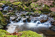
Ilsetal with Brocken (2012) |
||
| Data | ||
| Water code | EN : 4824 | |
| location | Harz and Harz foreland ; Saxony-Anhalt and Lower Saxony ( Germany ) | |
| River system | Weser | |
| Drain over | Oker → Aller → Weser → North Sea | |
| source | in the Harz at Heinrichshöhe 51 ° 47 ′ 15 ″ N , 10 ° 38 ′ 14 ″ E |
|
| Source height | approx. 960 m above sea level NHN | |
| muzzle | at Börßum in the Oker coordinates: 52 ° 4 ′ 9 ″ N , 10 ° 34 ′ 11 ″ E 52 ° 4 ′ 9 ″ N , 10 ° 34 ′ 11 ″ E |
|
| Mouth height | approx. 82 m above sea level NHN | |
| Height difference | approx. 878 m | |
| Bottom slope | approx. 20 ‰ | |
| length | 42.9 km NI portion: 8.7 km |
|
| Catchment area | approx. 290 km² NI share: 64.93 km² |
|
| Discharge at the Hoppenstedt A Eo gauge : 160 km² Location: 11.3 km above the mouth |
NNQ (07/03/1954) MNQ 1930/2014 MQ 1930/2014 Mq 1930/2014 MHQ 1930/2014 HHQ (07/18/2002) |
30 l / s 255 l / s 1.2 m³ / s 7.5 l / (s km²) 14.5 m³ / s 50.1 m³ / s |
| Left tributaries | Kellbeek , Großer Sandtalsbach , Suenbeek , Kienbach , Ochsenbach , Nonnenbach , Stimmecke | |
| Right tributaries | Loddenke, Rammelsbach , Schneibekebach , Ellergraben , Wöhrengraben , Zieselbach , Schiffgraben , Hasenbeeke as well as in the Alte Ilse Hahnenbeek , Großer Graben (Alte Ilse) | |
| Small towns | Ilsenburg | |
| Communities | Osterwieck , Veckenstedt , Wasserleben , Hornburg , Börßum | |
| Water body LHW: WESOW20-00 (upper course), WESOW21-00 NLWKN : 15019 (Mühlen-Ilse), 15020 (Canal-Ilse) |
||
The Ilse , called Verdeckte Ilse in the upper reaches and Kanal-Ilse and Mühlen-Ilse in the lower reaches , is a 42.9 km long, south-eastern and orographically right-hand tributary of the Oker in Saxony-Anhalt and Lower Saxony ( Germany ). It flows in the Harz and northern Harz foreland .
Course and catchment area
The Ilse rises in the Harz district of Saxony-Anhalt in the Upper Harz . Your source is within the Nature Park Harz / Saxony-Anhalt in the Harz National Park on the eastern slope of the Heinrichshöhe . It is located near Brockenstrasse ( K 1356), at about 960 m above sea level. NHN .
Initially the Ilse flows through the valley called Brockenbett between the Heinrichshöhe and the Brocken in the west and the Renneckenberg in the east. North-northeast of the Brocken it runs - in sections in the upper reaches invisible to the observer - as the Covered Ilse gurgling under large boulders that cover the river bed as an ice-age block glacier . At the north-northeast foot of the Brocken, which it passes to the east, the brook cuts a narrow valley into the high plateau of the Harz, in which it forms a series of small cascades, known as the Ilse Falls and accompanied by the Heinrich-Heine-Weg .

After a sharp bend to the right, the Ilse flows for a short distance in a longitudinal valley that runs parallel to the northern edge in the interior of the Harz Mountains. The then narrower Ilse Valley is dominated to the east by the rugged, cross-crowned Ilsestein .
After leaving the Harz National Park, the Ilse flows through Ilsenburg , where it crosses under the Krugbrücke and is then guided under the former copper smelter in the tunnel. Below Ilsenburg it enters the Harz foreland and flows through or passes the villages of Veckenstedt and Wasserleben , where it leaves the Harz / Saxony-Anhalt Nature Park after the Schneibekebach flowing in from the right . It swings to the northwest at Berßel , leaves the Großer Fallstein on the right and follows the course of the Kleiner Fallstein to the northeast below Osterwieck . Behind Hoppenstedt and the stage at Rimbeck it picks up the voice corner flowing in from the left , which rises in the Eckertal and is also fed from the Ecker , and reaches the Lower Saxony district of Wolfenbüttel . At the height of Willeckes Lust , the Mühlen-Ilse branches off to the east and flows through the Hagenmühle watermill structure in the center of Hornburg, which can still be visited today .
The other part of the Ilse passes Hornburg's town center to the west and is called Kanal-Ilse in the lower reaches . In this opens the confluence of the Schiffgraben-west , bounded by the Great break flows, and the mill Ilse , previously the Zieselbach receives.
West of Börßum in Lower Saxony , the Ilse flows into the Aller tributary Oker at an altitude of about 82 m after the eastern tributary of the Hasenbeeke . Until the regulation of Oker and Ilse, it reached the Oker shortly before the historic crossing of Ohrum near Pillowbrück , see the following section on the Alte Ilse .
The catchment area of the Ilse is about 290 km²; 64.93 km² of this is in Lower Saxony. The Ilse is the easternmost river from the Harz in the Oker catchment area and separates the catchment area of the Weser from that of the Elbe .
Old Ilse

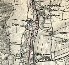
A four-kilometer section of the former course of the Ilse near Hedwigsburg is known as the Alte Ilse . Up until 1950, three bodies of water flowed in the Okeraue between Börßum and Dorstadt : the Warne meandered on the western edge of the lower terrace and flows into the Oker at the former monastery and today's estate; in the middle the Oker meandered and formed the historical border between the dioceses of Hildesheim and Halberstadt; the Ilse ran relatively straight on the eastern edge. It made a slight curve to the west on Waustenberg and was used in 1580 for the garden design of Hedwigsburg Castle . Shortly before Ohrum it flowed into the Oker, thus completing all of the Harz rivers that the Oker absorbs. The danger of flooding in Ohrum was correspondingly high, which regularly led to flooding and the erosion of meadows.
As early as 1937, the neighboring communities merged to form the Oker-Ilse Association, which began a generous restructuring of the Okeraue in 1951. The Oker was led completely into the bed of the Ilse at Börßum and the old Oker bed filled. Since then, the confluence of the Ilse and the Oker has been there. Between Börßum and Dorstadt, the Oker was led into a new canal bed and straightened to Ohrum. In Ohrum itself the oker arms were dissolved. The warning was straightened in the train and carried about in the old Okerbett. The success of this measure, which destroyed the natural course of the Oker, was moderate, only the construction of the Oker dam could contain the danger of spring floods. The course of the Warne has recently been renatured in sections in the old Okermeanders near Heiningen.
The old course of the Ilse has been preserved below Bornum to this day. It continues to take up the Hahnenbeek and Großer Graben streams flowing in from the east and serves as a receiving water for the Pilsenbrück sewage treatment plant. In the course of the water assessment according to the European Water Framework Directive , however, it is not treated as a separate water body .
Water supply
The abundant groundwater resources in the triangle of Kanal-Ilse and Oker are used by Salzgitter AG for the drinking water supply to Salzgitters and the iron and steel works. A total of 88 wells in the Börßum-Heiningen groundwater works pump more than 22 million cubic meters per year through 1.2 meter thick concrete pipelines to the processing plant in Adersheim.
Water quality
The Ilse is monitored with regard to the water quality and the implementation of the European Water Framework Directive by the State Office for Flood Protection and Water Management Saxony-Anhalt, which divides it into two geographical sections: From the source to the crash in Ilsenburg (as surface water body with the number WESOW20-00) and on to the confluence with the Oker in Lower Saxony (under the OWK no. WESOW21-00).
More than 50% of the upper reaches of the 13-kilometer long upper course were rated “very good” in terms of structural quality in the 2008 data sheet of the state office , ie “predominantly natural”. The biological quality and the chemical status are "good", but the overall classification of the ecological status is "moderate" because the orientation parameters for the oxygen content and the pH value have not been adhered to.
The section from Ilsenburg to the mouth is classified as a heavily modified water body ("HMWB" - Heavy Modified Water Body), which can be attributed to tunneling, straightening and dyke structures. The biological-chemical status is only given a rating of “4”, which is due to reduced oxygen levels and exceeded phosphate levels (for example from fertilizers). The total ecological potential is given as "unsatisfactory".
Saga and literature
The folk tale personifies Ilse as the beautiful princess Ilse , who lives in the rock of the Ilsestein . The river is mentioned in literature in Heinrich Heine's Harz journey, among others .
“It is indescribable with what cheerfulness, naivety and grace the Ilse rushes down over the adventurously formed pieces of rock, so that the water hisses wildly up here and down again over the small stones, like a lively girl. Yes, Ilse is a princess who runs down the mountain laughing and blooming. "
Web links
- Map with Ilse course , on openstreetmap.org
- Map with the course of the Alte Ilse , on openstreetmap.org
- Map of surface water bodies : Observation area WES (Oker) , State Office for Flood Protection and Water Management (LHW), on wrrl.sachsen-anhalt.de
- Water report on surface water 2005–2008 - tabular part , State Office for Flood Protection and Water Management (LHW) Saxony-Anhalt, State Service for Water Sciences, on lhw.sachsen-anhalt.de
- NLWKN : Water body data sheet 15020 Ilse-Unterlauf (as of December 2016) with recommendations for action, on Umweltkarten-niedersachsen.de (PDF; 84.75 kB)
Individual evidence
- ↑ a b c d Map services of the Federal Agency for Nature Conservation ( information )
- ↑ a b c d e f g Oker - Tables 1 + 2: Description of the water body + the main values of water science (federal-state information and communication platform), on wasserblick.net (PDF; 53 kB)
- ↑ NLWKN : Area directory for the Lower Saxony Hydrographic Map (catchment area in relation to the Ilse Canal : 290.36 km²), as of 2010, p. 55., accessed on August 19, 2013, on umwelt.niedersachsen.de (PDF; 599.8 kB )
- ^ Deutsches Gewässerkundliches Jahrbuch Weser-Ems 2014. Lower Saxony State Agency for Water Management, Coastal Protection and Nature Conservation, p. 180, accessed on October 4, 2017 (PDF, German, 8805 kB).
- ↑ Lower Saxony State Office for Water Management and Coastal Protection (today NLWKN ): Water quality report Oker 2002 , p. 44, Braunschweig, 2002
- ↑ Elisabeth Reifenstein, Ed. Municipality of Ohrum: Chronicle Ohrum 747–1997 , Wolfenbüttel 1997, S: 505 ff.
- ↑ WEVG waterworks: drinking water supply area of the WEVG , accessed on March 3, 2014, on wevg.com
- ↑ Map of surface water bodies : Observation area WES (Oker) , State Office for Flood Protection and Water Management (LHW), on wrrl.sachsen-anhalt.de

