Hasenbeeke
| Hasenbeeke | ||
|
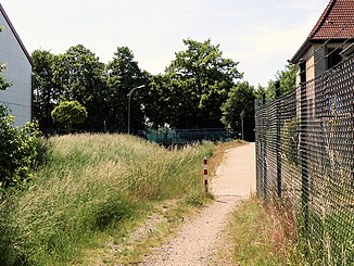
View over the Hasenbeeke before crossing the Börßumer Hauptstrasse. |
||
| Data | ||
| Water code | DE : 48248 | |
| location | Lower Saxony , Germany | |
| River system | Weser | |
| Drain over | Ilse → Oker → Aller → Weser → North Sea | |
| source | at Hedeper 52 ° 4 '26 " N , 10 ° 41' 2" E |
|
| Source height | 103 m above sea level NHN | |
| muzzle |
Börßum coordinates: 52 ° 4 ′ 1 ″ N , 10 ° 34 ′ 15 ″ E 52 ° 4 ′ 1 ″ N , 10 ° 34 ′ 15 ″ E |
|
| Mouth height | 83 m above sea level NHN | |
| Height difference | 20 m | |
| Bottom slope | 2.5 ‰ | |
| length | 8.1 km | |
| Catchment area | 16.12 km² | |
| Communities | Remlingen-Semmenstedt , Börßum | |
| Water body NLWKN: 15017 | ||
The Hasenbeeke is an approximately 8 km long stream in the Wolfenbüttel district , which has its source at the former Hedeper station on the Jerxheim – Börßum railway line on federal road 82 and runs in a straight line to the west along the former railway line. It flows into the Ilse in Börßum .
Geography and water quality
The place of origin is just a collection of a few buildings and bears the place name (Hedeper-) Bahnhof on official maps . The stream runs on both sides of the former railway embankment westwards to Kalme, turns slightly to the southwest and limits the settlement area of Börßum in the south. The Börßumer Hauptstrasse and the Braunschweig – Bad Harzburg railway line cross the stream shortly before it flows into the Ilse.
A lack of bank planting and a predominantly dead straight course give the water body a poor structural grade and an assessment as "heavily modified water body" . Regular drying out allows only a limited number of species to survive. In the local area of Börßum, the Hasenbeeke still has development opportunities in the green areas. The ecological potential is nevertheless given as “bad” and the chemical status as “not good”.
Elbe-Weser watershed
The Hasenbeeke belongs to the catchment area of the Weser . Immediately to the east of Hedeper, the brooks flow to the Neuer Graben in the Großer Bruch , which is an extension of the Schiffgraben-West . Like the ship ditch, this trench is divided into a westward and an east-flowing part, with the east-facing part flowing off via the Bode and Saale to the Elbe . Accordingly, the Elbe-Weser watershed runs roughly along federal highway 82 in this area.
Web links
- Map of the Hasenbeeke at openstreetmap.org
- Publications of the state of Lower Saxony on the water quality of the Oker on www.wasserblick.net
- Downloads on water quality at nlwkn.niedersachsen.de
- Homepage wrrl-kommunal.de with a link to an information event on the waters around Börßum on March 14, 2014, accessed on March 9, 2015
Individual evidence
- ↑ a b c State Office for Geoinformation and Land Surveying Lower Saxony: Top 50 - Topographic Map 1: 50,000 Lower Saxony / Bremen , status 2000.
- ↑ NLWKN : Inventory of the implementation of the EU Water Framework Directive, Oker processing area , Braunschweig November 2004, Table 3.
- ↑ a b NLWKN : Lower Saxony contribution to the management plan of the Weser river basin community , December 2009, p. 128. 11 MB PDF file retrieved from the management plan and program of measures for the Weser FGE 2009 - 2015 March 29, 2015
