Halchter
|
Halchter
District town Wolfenbüttel
|
|
|---|---|
| Coordinates: 52 ° 8 ′ 32 ″ N , 10 ° 32 ′ 54 ″ E | |
| Height : | 81 m |
| Area : | 9.53 km² |
| Residents : | 1439 (December 31, 2017) |
| Population density : | 151 inhabitants / km² |
| Incorporation : | March 1, 1974 |
| Postal code : | 38304 |
| Area code : | 05331 |
|
Location of Halchter in Wolfenbüttel
|
|
Halchter [ ˈhalçˌtɐ ] is a district of the city of Wolfenbüttel . It currently has around 1,450 inhabitants in around 550 households. Halchter was first mentioned in a document in 1149 as Haletre .
history
Halchter was first mentioned in a document in 1149 as haletre with the establishment of the parish church of Halchter.
On March 1, 1974 Halchter was incorporated into the district town of Wolfenbüttel.
politics
Local council
Since the local election on September 11, 2016, the local council has been composed as follows (changes compared to 2011):
Local mayor
The local mayor is Gerhard Kanter (CDU).
coat of arms
The coat of arms shows a three-leaf symbolically stylized tree in alternating colors in a red-yellow or red-gold split shield.
The tree represents the meaning of the place name "talking": the second half -ter goes back to the old Germanic 'tere' for 'tree' (cf. English 'tree'), the first half of the word could go back to 'holy', so that Halchter could be translated as "holy tree". The three sheets are intended to indicate that the place has existed three times: as an old settlement in the Neolithic Age (5000–1800 BC), as a settlement during the Roman Empire and the Migration Period (up to approx. 500 AD), as well as today's village, attested in writing in 1149 AD.
The shield division reminds on the one hand of the ducal Brunswick coat of arms colors and on the other hand of the Hildesheim pen colors. The middle dividing line of the shield represents the old Heerstraße , today's Bundesstraße 4 , on which warlike armies have repeatedly passed through and damaged Halchter.
Culture and sights
Windmill
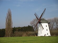
The miller August Scholkemeyer built the Dutch windmill on the Bungenstedter Tower in 1877. It came from the water mill near Apelnstedt . The mill tower was built by a mason from Halchter, the actual windmill by the mill construction company Max Erhardt from Wolfenbüttel. In addition to two grinding passages and one shot pass and an iron gear train, the mill contained various sieving and cleaning machines. It was leased to the bricklayer August Habekost in 1929 and bequeathed to his wife in 1937. In 1956 the mill, now operated by Walter Habekost, was shut down. At that time it was already running on a diesel engine. In 1983, a support association for the preservation of the windmill was founded, which had it restored in 1988. In 1992 new wings were added, so that the mill is still an operational technical monument that is located on the Lower Saxony Mühlenstraße .
church
Little is known about the early history of the Halchter parish church. Since 1983 it has also been the parish seat for the parishes of Ohrum and Dorstadt .
Individual evidence
- ^ Population of the localities and districts of Wolfenbüttel
- ^ Website of the communal data processing in Oldenburg , accessed on October 2, 2016
- ^ Federal Statistical Office (ed.): Historical municipality directory for the Federal Republic of Germany. Name, border and key number changes in municipalities, counties and administrative districts from May 27, 1970 to December 31, 1982 . W. Kohlhammer GmbH, Stuttgart and Mainz 1983, ISBN 3-17-003263-1 , p. 273 .
- ^ Arnold Rabbow: New Braunschweigisches Wappenbuch, Braunschweig 2003, p. 163.
- ↑ The Dutch windmill at the Bungenstedter Turm on the Lower Saxony Mühlenstrasse website , accessed on August 14, 2015


