Wittmar
| coat of arms | Germany map | |
|---|---|---|

|
Coordinates: 52 ° 8 ' N , 10 ° 38' E |
|
| Basic data | ||
| State : | Lower Saxony | |
| County : | Wolfenbüttel | |
| Joint municipality : | Elm aces | |
| Height : | 131 m above sea level NHN | |
| Area : | 4.65 km 2 | |
| Residents: | 1114 (Dec. 31, 2019) | |
| Population density : | 240 inhabitants per km 2 | |
| Postal code : | 38329 | |
| Area code : | 05337 | |
| License plate : | WF | |
| Community key : | 03 1 58 036 | |
| LOCODE : | DE OP8 | |
| Mayor : | Andreas Becker ( SPD ) | |
| Location of the municipality of Wittmar in the Wolfenbüttel district | ||
Wittmar is a municipality and a former mining village on the Asse in the Wolfenbüttel district . Wittmar belongs to the joint municipality of Elm-Asse , which has its administrative headquarters in the town of Schöppenstedt .
geography
Wittmar is located on the southwest slope of the ridge of the Asse, which extends from northwest to southeast, on the trunk road leading from Wolfenbüttel to Halberstadt, today's B 79 , also known as Leipziger Strasse . The gently ascending Asseweg leads from the village into the wooded area of the ridge that branches off to Asseburg and in the opposite direction to the Asse mine . The Rothebach that flows to Altenau rises in the village .
Neighboring towns are Groß Denkte in the northwest and Remlingen in the southeast .
history
In 1976 evidence of settlement sites in the Wittmar area was found that existed during the Stone Age and the Bronze Age. After an excavator hit bones while working on the ground , extensive excavations took place. They unearthed the Wittmar cemetery as a Neolithic cemetery for the band ceramists from the 4th millennium BC and a late Bronze Age settlement.
The name of Wittmar, first mentioned in a document in 1244, is made up of the Low German word "witt" for white (Low German) and the word "mär" (Old High German) for swampy area ("white swamp").
The church has had no steeple since 1850 after a lightning strike . One of the oldest inhabited houses in the Brunswick region is a dungeon called more than 500 years old house in the old village. In the past it also served as a toll collection station.
Former mining
The village of Wittmar was shaped as a mining town. Mining began on March 25, 1899 with the groundbreaking ceremony for potash mining near today's asset economy. At that time, Wittmar had 180 inhabitants, six years later it had 850 (as of July 1, 2008: 1,267). The employees had large and well-equipped apartments on Asseweg and Bismarckstrasse. The mine director resided in a villa right on the edge of the forest on today's Kastanienallee . Right next to the director's house there is still a double villa today, which was inhabited by the operations manager and the chief engineer . The simple workers lived in the small apartments on Bahnhofstrasse, with an outside toilet and a small stable. A forest swimming pool was built by the miners in 1939 in 10,665 voluntary hours of work, but it was only operated for one summer because the water kept leaking from the leaky pool.
In July 1906 water broke into the shaft and production had to be stopped. A new shaft was sunk near Remlingen , the salt of which was transported by cable car to the factory in Wittmar. As early as 1908, production could be continued at the Wittmar plant. The crises in the potash industry after the First and Second World Wars were felt here too, and production was switched to rock salt . The popular "Asse sun salt" was exported to many European countries.
With the closure of the mine in 1964, the history of mining in Wittmar ended. Only a tram in the village and the miners' association still remind us of the mining era. However, some mine workers live from the neighboring Asse II mine in Remlingen in Wittmar.
Population development
|
|
|
The data come from the information provided by the Lower Saxony State Statistical Office. From 2006 onwards, they relate to December 31 of each year.
religion
The Evangelical Lutheran St. Barbara Church is located at Kirchstrasse 22, and its parish belongs to the Schöppenstedt provost. The New Apostolic congregation Wittmar was affiliated to the Wolfenbüttel congregation in 2007. The Catholic residents belong to the parish of St. Petrus in Wolfenbüttel.
politics
Municipal council
The local council from Wittmar consists of eleven councilors
coat of arms
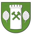
Blazon : "In green, a silver (white) castle tower removed from two silver (white) beech leaves, covered with green crossed mountain hammers."
Culture and sights
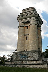
- Above the village is the Bismarck Tower on the ridge of the Asse castle hill , which was designed in 1901 in the shape of the Götterdämmerung , popular since 1898 . It is open to the public outside of the winter months and offers a view of the town and the Harz foreland to the Brocken from its viewing platform .
- At a distance of 200 meters from the Bismarck Tower are the remains of the Asseburg , built by Gunzelin von Wolfenbüttel , which was completed in 1218 and destroyed in 1492.
- A historic hornbeam avenue, the “Liebesallee”, leads from the Försterhaus up to the Asserand to around the Bismarck Tower. More recently, the beech trees that were previously used for snow -making have been freed from the surrounding vegetation and the path has been graveled so that the alley-like structure can be experienced again. The history of the path is documented on an information board.
- Before the path from the village to the Asse leads up to the slopes, there has been "forest management to Asse" for more than 150 years on the grounds of the old forester's house, which was demolished in 1834 . It was later replaced in the immediate vicinity by a small “princely palace” designed by the Brunswick architect Carl Ottmer . In addition to the apartment for the forester, a room was provided for the sovereign, which is said to have served as a love nest at times. This house, planned by Duke Wilhelm von Braunschweig, is still the seat of the Asse district forester today.
Economy and Infrastructure
The Assebummler - also known as the Prussian train - is a historic rail connection between Braunschweig , Wolfenbüttel and the Waldgaststätte in Wittmar. The steam train runs four to five times a year for tourists. It is operated by the Braunschweiger Verkehrsfreunde e. V.
The Braunschweig-Schöningen Railway, on the other hand, has been shut down and is no longer used.
The place is connected to the local public transport via a bus line of the Kraftverkehrsgesellschaft Braunschweig . The federal road 79 and the Eulenspiegel cycle path cross the town.
Web links
- Location description at the Asse local authority and tourist office
- Samtgemeinde Elm-Asse, location description Wittmar
Individual evidence
- ↑ State Office for Statistics Lower Saxony, LSN-Online regional database, Table 12411: Update of the population, as of December 31, 2019 ( help ).
- ↑ Chr. Rinne, B. Krause-Kyora: Genetic analysis on the multi-period grave field of Wittmar, Ldkr. Wolfenbüttel. Archaeological Information 37, 2014, 33-41 doi : 10.11588 / ai.2014.0.18189 (currently not available)
- ↑ Description of the Bismarck Tower. In: Heimat- und Verkehrsverein Asse. Hva-asse.de, accessed on January 5, 2017 .
- ^ Bismarck tower Wittmar. Bismarcktuerme.de, accessed on January 5, 2017 .
- ↑ Liebesallee. In: Heimat- und Verkehrsverein Asse. Hva-asse.de, accessed on January 5, 2017 .


