Aces
| Aces | |
|---|---|
| Highest peak | Remlinger Herse ( 234 m above sea level ) |
| location | Wolfenbüttel district , Lower Saxony ( Germany ) |
| Coordinates | 52 ° 8 ′ N , 10 ° 39 ′ E |
|
View from Wolfenbüttel east-south-east over Wendessen |
|
|
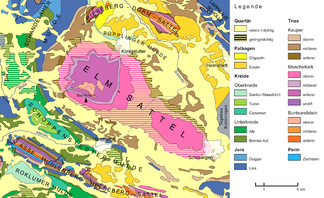
Geological map of the northern Harz foreland in the Braunschweig-Wolfenbüttel-Helmstedt area with the Asse at the bottom left |
|
The Asse is one to 234 m above sea level. NHN high, wooded ridge east-southeast of Wolfenbüttel in the Lower Saxony district of Wolfenbüttel ( Germany ).
The average height of the almost 9 km long and 3 km wide Asse is 200 m , which means that it towers over the surrounding area by around 100 m. The highest point is the Remlinger Herse at 234 m . When the weather is good, the ridge offers views of the Elm and Harz Mountains as well as the fertile loess areas of the Schöppenstedter and Remlinger Mulde .
The Asse is known nationwide for the Asse mine , a former salt mine which has been operated as a research mine since 1965 and in which the final storage of radioactive waste was practiced between 1967 and 1978 .
geography
location
The Asse rises in a north-west-south-east direction about 10 km north of the border with Saxony-Anhalt near Veltheim am Fallstein in the northern Harz foreland . It is located about 8 km east-southeast of the middle town Wolfenbüttel and 8.5 km west of the small town Schöppenstedt . Localities on the Asse are Groß Denkte in the west, Wittmar in the southwest, Remlingen in the south, Klein Vahlberg in the east-southeast, Groß Vahlberg in the east and Mönchevahlberg in the northeast. To the north, past the Asse, the Altenau flows roughly in an east-west direction , which flows into the Oker about 6.5 km west of the ridge on the southern outskirts of Wolfenbüttel . To the west-southwest lies the Oderwald , northeast of the Elm ridge , which is located in the Elm-Lappwald Nature Park , a few kilometers southeast of the Huy ridge and south of the Great Rupture, the Fallstein ridge , behind which the Harz rises.
geology

The rocks from which the Asse ridge is built originated in the Triassic (early Mesozoic , 250-200 million years ago). Relief development it is oolitic limestones of the Lower Bunter and sometimes very fossil- rich limestones of the Lower and Upper Muschelkalk . In the subsurface of the Asse there are large amounts of salt rocks that were precipitated from a sea (the Zechstein Sea ) in the " Zechstein Age " ( Oberperm ) more than 250 million years ago . These are primarily rock and potash salts from the Staßfurt, Leine and Aller series. The salt rocks are located in the core of a saddle structure (anticline), on the flanks of which the Triassic rocks plunge into the depths northeast and southwest.
The Assesattel was created as a result of complex tectonic processes, whereby the initial mobilization and ascent of the Zechstein salt ( halokinesis ) probably took place during a stretching phase in the Jura , but the final shape of the saddle in the course of compressive processes from the Cretaceous . The migration of the salt from the underground northeast and southwest of the Asse created marginal depressions that absorbed massive Cretaceous deposits, which, due to the increased sedimentary load in these areas, additionally drove the salt migration towards Asse. The remaining Zechstein salt lies under the edge depressions more than 2000 meters below the surface, while under the Asse it reaches up to 300 meters to the surface. The geological and physical map of the Asse, with the narrow stretches of the rock units that form narrow stratum ribs , the sometimes very steep dipping of the strata and the generally relatively narrow shape of the Asse show that it belongs to the narrow saddles . This saddle structure continues to the east to the Heeseberg . The special construction of the south-west leg of the Assesaddle was determined by deep drilling . While the preserved overburden is complete in the shallower dipping northeast leg , it begins in the steeper dipping southwest leg with the Upper Buntsandstein (Röt) . Middle and lower red sandstone are sheared off along the Röt rock salt and penetrate the Staßfurt rock salt in the core of the salt structure, lying almost horizontally.
Natural allocation
The Asse forms the natural area Asse (512.11) in the main unit group Northern Harz foreland (No. 51), in the main unit East Brunswick Hügelland (512) and in the subunit Asse-Elm-Hügelland (512.1 ). The landscape leads north and east into the natural area Schöppenstedter Lößmulde (512.13) and to the southeast via south to west into the natural area Remlinger Lößmulde (512.10). In the northwest, the natural area Salzdahlumer Hügelland (512.05) belongs to the subunit Okerrandhöhen (512.0) .
Surveys
The elevations of the Asse include - sorted by height in meters (m) above sea level (MSL; unless otherwise stated according to):
- Remlinger Herse (234 m), east of Wittmar , northwest of Remlingen
- Festberg (232 m), northeast of Wittmar, west of Mönchevahlberg
- Asseburgberg (227.5 m), north-northwest of Wittmar
- Röhrberg (225 m), north-northeast of Wittmar
- Watzenberg ( Watzeberg ; 222.5 m), east-northeast of Wittmar
- Hinterer Eichberg (220 m), north of Groß Denkte
- Rothenberg (220 m), northeast of Wittmar
- On the Klaare (216 m), north of Remlingen
- Middle Eichberg (201 m), east of Groß Denkte
- Meescheberg (188 m), south-southwest of Klein Vahlberg
- Vorderer Eichberg (185 m), east-northeast of Groß Denkte
Flowing waters
The flowing waters from the Asse flow into the Altenau coming from the Elm . This passes the Asse on the northern edge, where it takes up several field ditches flowing northwards. Further streams flow from the western slopes towards Wendesser Mühle into Altenau, which in the west follows the elevation of the Asse towards the south-west. At Klein Denkte it takes up the Rothebach , the source of which is on the outskirts of Wittmar. The Asse thus belongs mainly to the catchment area of the Oker and thus the Weser .
The southeast edge of the Asse near Remlingen is already part of the Elbe's catchment area , as the streams there flow to the Schöninger Aue or the Großer Graben .

Communities
Municipalities directly on the Asse are:
-
Elm-Asse municipality :
- Vahlberg , east
- Remlingen-Semmenstedt , southeast
- Wittmar , south
- Thought western
-
Collective municipality Sickte :
- Dettum , north
history
The settlement of the area (since the 6th millennium BC ) by Danube peasant cultures is directly related to the loess deposits in the Asse area . A Neolithic trade route running between the Elbe and the Rhine touches the southern edge of the Asse near Wittmar . The prehistoric importance of this area is underlined by the Neolithic cemetery of Wittmar and numerous other sites.
The Asse is mentioned as an Assa in an Ottonen deed in 997 .
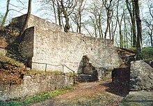
On a narrow Asse mountain ridge, the Asseburg hilltop castle was built from 1218 , an important imperial festival. The complex, which is difficult to conquer, has been a castle ruin since 1492 because it was abandoned by its owners and set on fire.
nature
flora
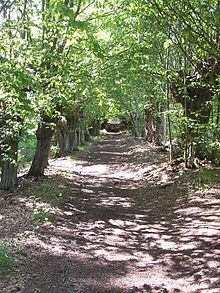
The Asse carries beech and deciduous mixed forest . It is worth mentioning the "Liebes-Allee" at Waldhaus Asse, where a new educational trail of the Open Air and Adventure Museum Ostfalen (FEMO) begins. The hornbeams ( Carpinus betulus ) standing here are relics of thousands of years of forest use. Elms , ash trees , linden trees and hornbeams were " cut " in full leaves , the branches were used for leaf hay extraction.
plants
At the beginning of May, the slopes of the Asse are transformed into a lush carpet of flowers. The ridge is a habitat for some very rare plant species. Well-known botanists claim that nowhere else in northern Germany is a comparable variety to be found. It starts with the so-called early bloomers: daffodils and primroses , Corydalis and wood anemone , arum and daphne . This is followed by a number of extremely rare orchids, such as the bee orchid . The varied blossoms persist until September.
643 plant species are named for the Asse, 102 of them endangered. Here, plant species reach their limit of distribution, which have their focus in the northern Mediterranean downy oak area, in continental European to Asian deciduous forest areas or even in the Alpine and foothills of the Alps; at least 20 species have their absolute north-western limit in the Asse. The Asse flora includes rarities such as the Immenblatt ( Melittis melissophyllum ), which has already become completely extinct in the rest of Lower Saxony. Even the very rare white cinquefoil ( Potentilla alba ) can still be discovered here. These botanical peculiarities have been known since Royer, the princely Brunswick gardener of Hesse Castle , and thus since the Thirty Years' War. Due to its water-permeable, nutrient-poor soil and the plant communities that settle on it, the Asse offers a wealth of small animals space to live, including many butterflies that have become rare. One of the problems in the ridge is the spread of the neophyte giant hogweed , which competes with the rare plants in the poor grass and makes conservation measures much more difficult.
The biodiversity in the Asse has natural reasons: Both the geological structure (see below) and the climatic conditions play a role here. On the one hand, the Asse is a steeply folded narrow saddle , on the slopes of which the rainwater drains quickly and the solar radiation is more intense. On the other hand, it lies exactly on the border between a mild maritime and a more severe continental climate. Because it rains considerably less here than in the rest of the Braunschweig region, the ridge is also the outermost outpost of the central German dry area around Halle. Numerous plants from both climatic regions grow on poor, semi-arid and dry grasslands, including tough steppe plants that can withstand extreme temperature changes.
Protected areas
The landscape protection areas (LSG) Asse (2020 designated; approx. 6.23 km²) and Asse, Klein Vahlberger Buchen and adjacent landscape elements ( CDDA no. 319679; 2001 designated; approx. 6.11 km²) are located on large parts of the Asse near Groß Vahlberg the small LSG "Park des Rittergut Groß Vahlberg" and "Der Schönebusch" (CDDA no. 323623; 1974; 5.1 ha ) are connected. A small part of the Asse is designated as the Remlinger Heerse nature reserve. The Asse fauna-flora-habitat area (FFH no. 3829-301; 6.48 km²) is also located on large parts of the ridge and is protected by the Asse landscape protection area and the Remlinger Heerse nature reserve .
Mining and nuclear waste disposal
Ace shaft
In the mining history of the Asse, carnallite was first mined, later Staßfurt and Leine rock salt . The geological section shows the southwest flank as an area of particularly intensive mining, i.e. in the area in which the layers of the overburden are steep. These interventions impaired the state of tension in the salt saddle. Redistributions led to deformations here and in the overburden, which paused up to the surface.
Asse mine

The Helmholtz Zentrum München - German Research Center for Health and Environment , formerly GSF - Research Center for Environment and Health and Society for Radiation and Environmental Research, acquired the former Asse II salt mine from Wintershall AG in 1965 . On behalf of the federal government, the GSF carried out research into the safe disposal of radioactive waste in the Asse II mine between 1967 and 1978 . During this time, around 125,000 barrels of low-level radioactive waste and around 14,779 (SZ of 11/12 September 2010) containers with medium-level radioactive waste were stored. Saline solution ingress has been observed in the southern flank of the Asse mine since 1967. It is assumed that the resulting solution, currently around 12.5 cubic meters per day, comes to a large extent from the overburden and enters the mining-related loosened saline of the southwest flank through areas of the Upper Buntsandstein (red anhydrite) that have been loosened up by mining. On January 1, 2009, responsibility for continued operation and decommissioning was transferred to the Federal Office for Radiation Protection ; From this point on, the facility is also subject to nuclear law and no longer to mining law .

Attractions
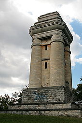
As well as the local forest landscape, the Asse's sights include the ruins of the Asseburg , which is located in the western part of the ridge east-southeast of Groß Denkte on the Asseburgberg. The Wittmarer Bismarck Tower stands about 440 m south-east of the ruin on the south- eastern spur of the narrow mountain ridge north of Wittmar . A forest path from Wittmar to Asse leads to the listed forester's house from 1835, the "Prince's Castle".
Transport links
The Asse ridge can be reached via federal road 79 , which runs along the ridge in the south-west of Groß Denkte through Wittmar to Remlingen , and via federal road 82 , which passes a little southeast between Berklingen and Semmenstedt . From the B 79 branches off in Groß Denkte, the district road 3 running north past the ridge to Mönchevahlberg , which merges into the K 628 leading to Groß Vahlberg . There the K 513 branches off to Remlingen, where it meets the B 79.
Web links
Individual evidence
- ↑ a b c d Map services of the Federal Agency for Nature Conservation ( information )
- ↑ a b Tanja Szymaniak, Michael Schäfer: Geological-tectonic mapping of the salt structure Asse in the Subhercynen Basin. Diploma mapping, Clausthal University of Technology, Institute for Geology and Paleontology, Clausthal-Zellerfeld 2002 ( PDF 24 MB)
- ↑ Kurt Mohr: Geological Guides Collection, Vol. 70, Harz foreland - western part , p. 23. Bornträger Brothers, Berlin 1982, ISBN 3-443-15029-2 .
- ↑ Fritz J. Krüger (Ed.): Wanderings in die Erdgeschichte, Vol. 19, Braunschweiger Land , pp. 29–45. Publishing house Dr. Friedrich Pfeil, Munich 2006, ISBN 3-89937-066-X
- ^ Theodor Müller : Geographische Landesaufnahme: The natural space units on sheet 87 Braunschweig. Federal Institute for Regional Studies, Bad Godesberg 1962. → Online map (PDF; 4.8 MB)
- ↑ Topographic map with the Asse ( memento of the original from February 27, 2016 in the Internet Archive ) Info: The archive link has been inserted automatically and has not yet been checked. Please check the original and archive link according to the instructions and then remove this notice. (Heights according to magnification levels DTK50 – AK2.5), on natur-erleben.niedersachsen.de
- ↑ Gabriel urges a fundamentally new approach to handling the Asse (Federal Ministry for the Environment, Nature Conservation and Nuclear Safety), from September 2, 2008, on bmub.bund.de


