
Heeseberg
| Heeseberg | ||
|---|---|---|
 Heeseberg (from the west) |
||
| height | 200 m above sea level NHN | |
| location | northeast of Beierstedt , Lower Saxony | |
| Coordinates | 52 ° 5 '1 " N , 10 ° 52' 16" E | |
|
||
| particularities | Heeseberg Tower ( AT ) | |
 View from Heeseberg to Beierstedt and the Harz Mountains |
||

The Heeseberg is a 200 m above sea level. NHN high elevation in the joint community of Heeseberg in the Helmstedt district ( Lower Saxony ).
description
The climate is warm and dry and, together with the good soil, offers good conditions for agriculture. The mountain was therefore used for agriculture early on. Therefore, there are only smaller forest areas on the Heeseberg in the eastern, southern and outer north-western areas.
The rare spring adonis are found on the Heeseberg . In March and April the spring Adonis flowers bloom in a bright yellow color on the southern slope of the Heeseberg.
In addition to an inn built in 1967, there is also an approx. 20 m high observation tower on the Heeseberg, which Karl Kleye , member of the Reichstag and Jerxheim mayor , had his own funds built in 1912. Large parts of the area are designated as a nature reserve and landscape protection area.
In the area of the Heeseberg there is a geopath of the open-air museum FEMO in the Geopark Harz - Braunschweiger Land - Ostfalen . The geopath begins at the restaurant and leads past a total of seven points, including three quarries. One of the three quarries was designated a national geotope .
archeology
In the Bronze Age of Heese mountain in the western range was Watenstedt the Hünenburg at Watenstedt . During the 2nd and 3rd centuries there was a Germanic homestead within the remains of this ring wall . In the 6th century, the Old Saxons expanded the Hünenburg into a prince's castle and ruled from here in Ostfalen . Between 772 and 785 the facility was expanded again by the Franks .
geography
The Heeseberg extends roughly in the WNW-ESE direction and is located in eastern Lower Saxony . The distance to the state border of Saxony-Anhalt is only about 2.9 km. The Heeseberg is about 24 km from Wolfenbüttel . To the north of the Heeseberg is the town of Ingeleben , to the west of the Heeseberg is Gevensleben , to the south is the town of Beierstedt and to the east is Jerxheim .
geology
The Heeseberg is located in the northern Harz foreland , which is also known as the subhercyne valley. The Heeseberg consists of sediments of the Lower Buntsandstein, which is assigned to the Triassic . The Triassic forms the lowest system of the Mesozoic Era .
The sediments of the Lower Buntsandstein are highly weather-resistant and therefore form a morphological rib. The sediments of the Lower Buntsandstein are intensely red in color and can therefore be easily classified in the outcrop.
._Nr._6_ist_als_nationales_Geotop_ausgezeichnet..jpg)
The Lower Buntsandstein consists of clastic sediments and oolites and stromatolites in the Harz foreland (subhercyne depression) . In the Harz foreland, oolites are known as roe stones because of their appearance , which is similar to fish roe .
The observation tower on the Heeseberg is also built from roe stones, which were most likely mined on the Heeseberg. This is indicated by the quarries and still recognizable pings.
Due to the rise of the salts that were deposited in the Zechstein in the Harz foreland, numerous saddles were created in the Harz foreland . In the course of this salt tectonics , salt diapirs (also known as salt domes) and salt pillows formed from rock and potash salts . The Heeseberg and the Asse form a narrow saddle .
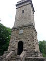
Lookout tower on the Heeseberg

Staircase to the lookout tower

Quarry on Heeseberg

Rogenstein am Heeseberg


See also
Web links
Individual evidence
- ↑ Map services of the Federal Agency for Nature Conservation ( information )
- ↑ a b Geology / Nature Adventure Trail Heeseberg , Open-Air and Adventure Museum Ostfalen, accessed on July 25, 2010.
- ↑ Adonisröschen on Heeseberg near Jerxheim. In: braunschweig-touren.de. Braunschweig Tours, accessed April 20, 2017 .
- ^ Heeseberg Tower in the Helmstedt Wiki, accessed on August 7, 2012.
- ↑ Geopfad Heesebeg at geopark-hblo.de, accessed on April 14, 2018
- ^ Prospectus of the Braunschweigisches Landesmuseum
- ↑ Lydia Bäuerle, Wolfhard Klie (ed.): Excursion guide Braunschweig, from Harz to Heide. S. 79. Höller and Zwick, Braunschweig 2nd edition 1990, ISBN 3-89057-009-7 .
- ↑ Fritz J. Krüger (Ed.): Walks in the Earth History, Volume 19, Braunschweiger Land. Pp. 53-58. Publishing house Dr. Friedrich Pfeil, Munich 2006, ISBN 3-89937-066-X .