
Heeseberg (nature reserve)
|
Heeseberg
|
||
 Outcrop in the former quarry |
||
| location | Southwest of Helmstedt , Helmstedt district , Lower Saxony | |
| surface | 51 ha | |
| Identifier | NSG BR 008 | |
| WDPA ID | 81843 | |
| Geographical location | 52 ° 5 ' N , 10 ° 52' E | |
|
||
| Setup date | 16th January 1973 | |
| administration | NLWKN | |

The Heeseberg nature reserve is located on the eponymous Heeseberg in the Lower Saxony municipalities of Beierstedt and Jerxheim in the Heeseberg municipality in the Helmstedt district .
The area with the registration number NSG BR 008, which consists of three sub-areas, is 51 hectares in size. It replaces the designated nature reserve of the same name on January 16, 1973. Adjacent regions as a conservation area designated "Heeseberg". The nature reserve is completely part of the FFH area “Heeseberg area”. The area has been a nature reserve since November 18, 1986. The responsible lower nature conservation authority is the Helmstedt district.
description
The nature reserve is located in the hill country of East Brunswick within the Geopark Harz - Braunschweiger Land - Ostfalen on the Heeseberg between Watenstedt in the west, Jerxheim in the east and Beierstedt in the south. The northern, largest part of the nature reserve is characterized by former limestone and red sandstone quarries . Here, as in the south-east lying sub-area, semi-arid grasslands and steppe grasslands occur. The area to the south is covered with bushes.
The nature reserve is a habitat for numerous endangered animal and plant species. In some of the former quarries, small, shallow ponds were created as a habitat for amphibians as a species relief measure .
Geological features
The westernmost and largest of abandoned quarries in the protected area, which can also be committed, conveys long along a roughly 60 meters and 10 meters high wall insight into the Rogenstein zone of lower red sandstone . On the Heeseberg, Ernst Kalkowsky assigned the name stromatolite when the sedimentary rock found here was first identified in 1908 , which made the Heeseberg a type locality . The quarry was opened on May 12, 2006 by the Hanover Academy of Geosciences. V. awarded the title “ National Geotope ”.
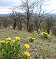
Spring Adonis on semi-dry grass in the NSG Heeseberg

View along the quarry wall


tourism
Through a part of the nature reserve a portion of a roughly 3.5-kilometer geology and nature runs adventure trail . The adventure trail leads past, among other things, red sandstone , a site of Ice Age debris and a dry grassland .
A little outside of the nature reserve in the eastern part of the Heeseberg there is an observation tower from which a panoramic view is possible.
literature
- Geotopes in the field of tension between protection and use , A pilot project of the Open Air and Adventure Museum Ostfalen (FEMO), final report, May 2008, pp. 56–58 ( PDF file , 8.1 MB).
Web links
- "Heeseberg" nature reserve in the database of the Lower Saxony State Office for Water Management, Coastal and Nature Conservation (NLWKN)
Individual evidence
- ^ Horst Wachendorf : Roe stones and algae reefs in the quarry at Heeseberg near Jerxheim , Lower Saxony State Office for Soil Research. Retrieved March 6, 2012.
- ↑ Nico Jäkel: Heeseberg quarry awarded “National Geotope” , Helmstedter Blitz, May 31, 2006. Accessed March 6, 2012.
- ↑ Geology / nature trail Heeseberg , open-air and adventure museum Ostfalen e. V . Retrieved March 6, 2012.
- ↑ Georoute Heeseberg , Geopark Harz. Braunschweiger Land. Ostfalen. Retrieved March 6, 2012.
- ↑ Geology-Nature-Adventure Trail "Heeseberg" , Geopark Harz. Braunschweiger Land. Ostfalen. Retrieved March 6, 2012.

