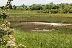
Seckertrift salt meadow
|
Seckertrift salt meadow
|
||
|
Queller corridors of the Seckertrift salt marsh near Jerxheim |
||
| location | Southwest of Helmstedt , in the Lower Saxony district of Helmstedt | |
| surface | 17 ha | |
| Identifier | NSG BR 011 | |
| WDPA ID | 82478 | |
| Geographical location | 52 ° 4 ' N , 10 ° 55' E | |
|
|
||
| Sea level | from 88 m to 89 m | |
| Setup date | 07/16/2014 | |
| administration | NLWKN | |
The Seckertrift salt meadow is a nature reserve in the Lower Saxony municipality of Jerxheim in the Heeseberg municipality in the Helmstedt district .
The nature reserve with the sign NSG BR 011 is around 17 hectares and largely part of the FFH area "Heeseberg area". The area has been under protection since July 22, 2014 (date of regulation: July 16, 2014). It replaces the on January 2, 1977 reported, the same nature reserve (date of the Regulation: December 14, 1976), which in turn an established in June 1969 conservation area replaced. The responsible lower nature conservation authority is the Helmstedt district.
The nature reserve is located southeast of Jerxheim. It protects a point of inland salt that has formed naturally in a depression about 500 meters long and up to 250 meters wide . The inland salt station is a special ecological feature with an unusual flora and fauna for the inland . It owes its creation to a salt cap made of Zechstein salt at a depth of around 200 meters . Salty groundwater rises from this and covers the surface in open puddles at times, so that here salt marshes and swampy, salty areas can be found. This is followed by fallow areas that have been included in the protected area since the expansion of the protected area as well as adjacent arable land . The nature reserve is traversed by a natural ditch that flows into the Seebeek. The water in the trench is also salty.
The salt area is a habitat for salt-tolerant plants ( halophytes ) and plant communities and appropriately adapted animals. So find z. B. samphire corridors, puccinellia lawn and brackish water - reedbeds with Genuine celery , beach aster , milkweed , salt rush , Exceptional puccinellia , Exceptional short ears samphire , salt Bunge , salt Schuppenmiere and serrated sweet clover . Andel rasen partially settles on fallow land on the edge of the protected area . At the edge of the salt patch, semi-brutal grass and herbaceous corridors grow. There is also a meadow orchard in the protected area.
The nature reserve can be experienced by visitors from an observation platform, which can be reached via a wooden plank path.
Web links
- Nature reserve "Salzwiese Seckertrift" in the database of the Lower Saxony State Office for Water Management, Coastal and Nature Conservation (NLWKN)
Individual evidence
- ↑ Regulation text NSG Salzwiese Seckertrift , Helmstedt district. Retrieved November 3, 2014.
- ↑ Landscape framework plan for the district of Helmstedt (PDF; 12.2 MB) , section salt vegetation in the inland, page 70. District of Helmstedt, Environment Agency. Retrieved February 28, 2012.
- ↑ Geotopes in the field of tension between protection and use (PDF; 8.5 MB) , nature protection and visitor management in selected geotopes of the Harz - Braunschweiger Land - Ostfalen geopark . Final report, May 2008, page 58. Open-air and adventure museum Ostfalen . Retrieved February 28, 2012.


