
Jerxheim
| coat of arms | Germany map | |
|---|---|---|

|
Coordinates: 52 ° 5 ' N , 10 ° 54' E |
|
| Basic data | ||
| State : | Lower Saxony | |
| County : | Helmstedt | |
| Joint municipality : | Heeseberg | |
| Height : | 114 m above sea level NHN | |
| Area : | 17.47 km 2 | |
| Residents: | 1124 (Dec. 31, 2019) | |
| Population density : | 64 inhabitants per km 2 | |
| Postal code : | 38381 | |
| Area code : | 05354 | |
| License plate : | HE | |
| Community key : | 03 1 54 012 | |
| Community structure: | 3 districts | |
| Address of the municipal administration: |
Helmstedter Strasse 17 38381 Jerxheim |
|
| Website : | ||
| Mayor : | Philipp Ralphs ( Jerxheim Citizens List ) | |
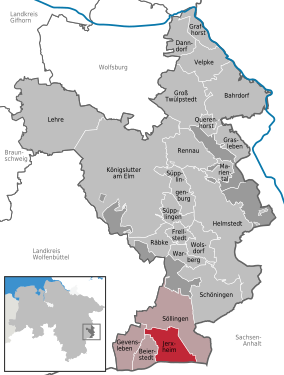
| Location of the municipality of Jerxheim in the Helmstedt district | ||
  |
||

Jerxheim is a municipality in the Helmstedt district in Lower Saxony .
geography
Geographical location
Jerxheim is located south of the Elm-Lappwald nature park and north of the Huy . The place is located on the Great Break and at the foot of the Heeseberg, which is visible from afar (200 m above sea level). The municipality is a member municipality and the administrative seat of the Heeseberg municipality .
Community structure
The districts of the municipality are:
- Jerxheim place
- Jerxheim train station
- Jerxheim settlement on the Heeseberg
Neighboring communities
Neighboring communities are Söllingen , Beierstedt , Gevensleben and Huy (Saxony-Anhalt).
geology

Geologically, the area is characterized by the Lower Buntsandstein and is known as the " Rogenstein Zone". In the Heeseberg area there were already arable crops in prehistoric times, as good arable soils such as loess and black earth occur here. The fossil algae lawn on the Heeseberg was included in the list of 77 awarded National Geotopes in 2006.
Heeseberg, located in the southeast of the Helmstedt district, is one of the northwestern foothills of the central German dry area. A unique flora and fauna with warmth-loving plant and animal species that are not very sensitive to drought can be found here. Large parts of the Heeseberg are nature reserves .
history
.jpg)
The community was first mentioned in a document in 1195. In 1313, a castle "Gerksem" was mentioned in a document owned by the Knights of Alvensleben. A noble family with the name Jerxheim is also mentioned. Matthäus Merian describes in 1654 that Jerxheim was a county in the Middle Ages. Merian describes Jerxheim Castle around 1650 as a four-sided complex with a moat. The house must have been very old back then. The building was later demolished. Several old barns from the time and a manor house built in the 19th century still stand on the site.

In 1846 Jerxheim had 974 inhabitants and already had a train station, which was laid out with a settlement about two kilometers south of the village and was the crossing point for several railway lines, all of which are now closed (see below). On September 9, 1844, a passenger train derailed on the line between Jerxheim and Neuwegersleben on the Braunschweig – Oschersleben line. A switchman or a railway attendant is said to have not tightened a rail sufficiently. Some passengers were injured. This accident was the first railway accident in Germany and one of the first worldwide and is known today as the Jerxheim railway accident .
There was also a sugar factory in Jerxheim Bahnhof from 1851 to 1975.
Place name
Old names of the place are around 1153 Gercseim, 1189 Jericksen, 1196–1197 Gereksheim, 1196–1197 Yerxem and 1196–1197 Jerkesheim.
In the second part of the place name, the Low German “-hēm” stands for “Heim, Siedlung”, in the first an old first name, perhaps “Gerik (i)” or “Gar-ik (i)”. It is questionable whether “Gar-” belongs to the personal name stem “Garva” or “Gairu”. Also the old Saxon attested two-part personal name "Gerrik" is to the personal name trunk "Gairu", whose member "-rik" is to be put to the personal name trunk "Ricja" for "rich, powerful".
Postal history
A small post office, a so-called postal expedition , had existed in Jerxheim since 1843. For the development of the postal system in Jerxheim, see: Post route Braunschweig-Helmstedt-Magdeburg .
politics
Municipal council
The council of the Jerxheim community consists of 10 councilors and councilors. This is the specified number for the member municipality of an integrated municipality with a population between 1001 and 2000 inhabitants. The council members are elected for a five-year term by local elections. The current term of office began on November 1, 2016 and ends on October 31, 2021.
The mayor is also entitled to vote in the council.
The last local election on September 11, 2016 resulted in the following:
| Political party | Proportional votes | Number of seats |
|---|---|---|
| Citizens' List Jerxheim (BLJ) | 100% | 11 |
mayor
The honorary mayor is Philipp Ralphs (BLJ). His deputies are Marco Gritzan (BLJ) and Gerhard Lorenz Richter (BLJ).
coat of arms
The draft municipal coat of arms of the community Jerxheim comes from the Braunschweiger headmaster , heraldic and graphic artist Wilhelm war . The coat of arms was adopted by the municipal council on June 3, 1955 and approved by the Braunschweig administrative president on February 25, 1956.
|
|
Blazon : “In the divided coat of arms above in red a golden lion looking out; blue scissors in gold below. " |
| Founding of the coat of arms: Jerxheim has been the seat of a Brunswick office from time immemorial and therefore has one of the two golden ducal-Brunswick coat of arms lions in the upper half of its divided shield. The blue scissors in the lower field come from the coat of arms of the Lords of Jerxheim, who played a role here from 1200 to 1428. The lower half of the shield also confirms with the colors blue and yellow that the municipality has been part of the Braunschweig region for a long time. |
Culture and sights
The Heeseberg with a lookout tower and a mountain restaurant is surrounded by villages that are characterized by agriculture and have large Thuringian farms. The name of the municipality can be traced back to the survey. At the Heeseberg tower in the nature and landscape protection area there is a geology-nature adventure trail of the open-air and adventure museum Ostfalen (FEMO), from which a panoramic panorama opens up. There is a clear view of the Harz foreland and the Brocken massif of the Harz. The Elm can be seen in the north.
The Grosse Bruch passing by is a shallow Ice Age meltwater channel that is suitable for cycling.
music
Jerxheim has owned the "Gesangverein Liedertafel Jerxheim" e. V. The women's choir has been singing in the Heeseberg choir group since 2015. If possible, an Advent concert takes place every year on the 2nd Advent in the Protestant church.
Sports
Jerxheim has the following sports clubs:
- The ESV played football in the Jerxheim-Bahnhof district. The remaining players have been playing at FC Dobbeln / Jerxheim since 2008 due to membership decline.
- TSV Jerxheim is based in Jerxheim and the football department plays in the FC Dobbeln / Jerxheim syndicate. The TSV also offers other areas such as volleyball, tennis, gymnastics, Pilates, jazz, modern dance and Nordic walking.
- The sports facility in Jerxheim is home to the LG (athletics community) Heeseberg
- The Kyffhäuser Comradeship Jerxheim does shooting sports
- Riders are organized at the riding and driving club (Reitgemeinschaft-Elm-Heeseberg e.V.). You have a sand dressage court and a grass jumping area at the sports facilities.
Regular events
- The festival takes place every year in the third week of June
- On the last weekend in August there is a choir concert by the “Liedertafel Jerxheim” e. V. takes place in the DGH
Economy and Infrastructure
Jerxheim is the largest member community of the Heeseberg joint community. In addition to the headquarters of the administration, important community institutions are represented here. Jerxheim has doctors, restaurants, a retirement and nursing home (Haus am Heeseberg) and various retail shops for local supplies.
traffic

Jerxheim is located directly on the B 244 federal road , which leads from Helmstedt to Wernigerode .
Until 1945 Jerxheim was an important railway junction with routes to Nienhagen (near Halberstadt) , Wolfenbüttel / Oschersleben (on to Braunschweig and Hanover or Magdeburg), Börßum (on to Bad Harzburg, Paderborn and the Ruhr area) and Helmstedt . The first train from Berlin to Cologne or Deutz ran via Jerxheim in 1843 (→ History of the Railway in Germany ). The main line to Börßum was the first to be built with two tracks in 1868 . The station building was built in 1869. With the division of Germany , the main line to Oschersleben was interrupted, as was the branch line to Nienhagen. On October 1, 1984, the Jerxheim station was downgraded to a stopping point by the Deutsche Bundesbahn . The Schöppenstedt – Helmstedt section was closed in December 2007. Since then, the Jerxheim railway systems have not been used.
Public facilities
Jerxheim has a primary school, a kindergarten, two village community houses, a rifle tent and an old school. These rooms can be rented for celebrations.
The fire brigade base of the Heeseberg municipality is stationed in Jerxheim. There is also a police station manned half a day.
Religions

There are two Christian churches in Jerxheim:
- The Evangelical Lutheran St. Petrus Church, located between Pfarrwinkel and Schulstrasse, belongs to the Helmstedt Propstei
- The Catholic Church Maria von der Immerwazierenden Hilfe was built in 1925/26 on Helmstedter Strasse. Today the church belongs to the parish Maria Hilfe der Christisten in Schöningen and is the southernmost church in the dean's office in Wolfsburg-Helmstedt.
Personalities
Sons and daughters of the church
- Rudolph Friedrich Schultze (1738–1791), Protestant theologian
- Kurt Meyer (1910–1961), SS brigade leader and major general of the Waffen SS
- Jürgen Hoffmann (1944–2009), political scientist and university professor
People connected to the community
- Karl Kleye (1854–1923), member of the German Reichstag, initiator of the observation tower on the Heeseberg
literature
- Sten Nadolny : Network map . Paul List Verlag, Berlin 1981, ISBN 3-471-78220-6 (Jerxheim is mentioned in this novel in which the protagonist Ole Reuter , among other things, intends to name all train stations in Germany with an x in their name (according to his list: Buxtehude , Cuxhaven , Höxter , Xanten ) Nadolny describes the Jerxheim train station as a “chestnut beauty” (p. 92) and is amazed that Jerxheim train station is “a place of its own”, but Jerxheim itself is only “on the other side of a considerable hill” In the book, Ole Reuter also imagines a “baker's daughter in Jerxheim” several times, as the epitome of randomly occurring interesting things: “Only once you have been to Jerxheim at 6:46 without any destination, then you know what can become of it. …] In Jerxheim I imagine […] a detailed conversation with the baker's daughter as very, very invigorating. ”(P. 12)).
Web links
- Village website
- Reconstruction drawing of Jerxheim Castle by Wolfgang Braun
- Friedrich Brandes: Chronicle of Jerxheim Station, Helmstedt 1987. (PDF document)
Individual evidence
- ↑ State Office for Statistics Lower Saxony, LSN-Online regional database, Table 12411: Update of the population, as of December 31, 2019 ( help ).
- ↑ Stefan Röber, Henning Zellmer, Heinz-Gerd Röhling: Fossil algae lawns in the northern Harz foreland - "Stromatolites" on Heeseberg near Jerxheim . In: Ernst-Rüdiger Look, Ludger Feldmann (Ed.): Fascination Geology. The important geotopes of Germany . E. Schweizerbart'sche Verlagbuchhandlung, Stuttgart 2006, ISBN 3-510-65219-3 , pp. 12 .
- ^ Jerxheim in Merian's topography over the Guelph countries from 1654
- ↑ Reconstruction drawing of the castle based on Merian's description by Wolfgang Braun
- ^ Friedrich Brandes: Chronicle of the station Jerxheim . Kühne, Helmstedt 1987 ( digitized version ( memento from March 4, 2016 in the Internet Archive ) [PDF; 11.3 MB ; accessed on November 6, 2019]).
- ^ Jürgen Udolph (research): The "place name researcher". In: Website NDR 1 Lower Saxony . Archived from the original on December 2, 2016 ; accessed on August 4, 2019 .
- ^ Lower Saxony Municipal Constitutional Law (NKomVG); Section 46 - Number of Deputies. In: Lower Saxony Regulations Information System (NI-VORIS). December 17, 2010, accessed November 6, 2019 .
- ↑ a b c Jerxheim City Council. In: Website of the Jerxheim community. Retrieved November 6, 2019 .
- ^ Drafts of coat of arms by Wilhelm Krieg. In: Wikimedia Commons . Retrieved August 18, 2019.
- ^ Arnold Rabbow: Braunschweigisches Wappenbuch . The coats of arms of the communities and districts in the urban and rural districts of Braunschweig, Gandersheim, Gifhorn, Goslar, Helmstedt, Peine, Salzgitter, Wolfenbüttel and Wolfsburg. Ed .: Braunschweiger Zeitung, Salzgitter Zeitung and Wolfsburger Nachrichten. Eckensberger & Co Verlag, Braunschweig 1977, DNB 780686667 , p. 64-65 .
- ^ Dirk Fochler: Cycling in Helmstedt. In: Helmstedter Nachrichten. Edition of May 4, 2019 (Sunday supplement).
- ^ History 1980 to 1989. In: Website Landkreis Helmstedt. Retrieved February 25, 2018 .
Bahrdorf | Beierstedt | Danndorf | Frellstedt | Gevensleben | Grafhorst | Grass life | Groß Twülpstedt | Helmstedt | Jerxheim | Königslutter am Elm | Teaching | Mariental | Querenhorst | Räbke | Rennau | Schöningen | Söllingen | Süpplingen | Süpplingenburg | Velpke | Warberg | Wolsdorf
Municipality-free areas in the Helmstedt
Brunsleberfeld district |
Helmstedt |
Königslutter |
Mariental |
Schöningen