Wolsdorf
| coat of arms | Germany map | |
|---|---|---|

|
Coordinates: 52 ° 11 ' N , 10 ° 56' E |
|
| Basic data | ||
| State : | Lower Saxony | |
| County : | Helmstedt | |
| Joint municipality : | North Elm | |
| Height : | 134 m above sea level NHN | |
| Area : | 13.17 km 2 | |
| Residents: | 911 (Dec. 31, 2019) | |
| Population density : | 69 inhabitants per km 2 | |
| Postal code : | 38379 | |
| Area code : | 05355 | |
| License plate : | HE | |
| Community key : | 03 1 54 026 | |
| Address of the municipal administration: |
Steinweg 15 38373 Süpplingen |
|
| Website : | ||
| Mayor : | Sabine Siegmund | |
| Location of the community Wolsdorf in the Helmstedt district | ||
Wolsdorf is a municipality in the Helmstedt district in Lower Saxony .
geography
Wolsdorf is located in the Elm-Lappwald Nature Park . The municipality belongs to the combined municipality of Nord-Elm , which has its administrative seat in the municipality of Süpplingen .
history
The municipality was first mentioned in a document in 1182.
Economy and Infrastructure
traffic
Wolsdorf is west of the federal highway 244 , which leads from Helmstedt to Wernigerode .
Religions
The Evangelical Lutheran St. John's Church is located on the road to Frellstedt near the exit from the town; the responsible rectory is also in Frellstedt. The parish belongs to the Königslutter provost .
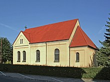
The Roman Catholic St. Joseph Church was built in 1914 and is located on the western edge of the village. Initially a branch church of St. Bonifatius Church in Süpplingen , today it belongs to the parish of St. Ludgeri in Helmstedt .
Individual evidence
- ↑ State Office for Statistics Lower Saxony, LSN-Online regional database, Table 12411: Update of the population, as of December 31, 2019 ( help ).


