
Grafhorst
| coat of arms | Germany map | |
|---|---|---|

|
Coordinates: 52 ° 27 ' N , 10 ° 57' E |
|
| Basic data | ||
| State : | Lower Saxony | |
| County : | Helmstedt | |
| Joint municipality : | Velpke | |
| Height : | 58 m above sea level NHN | |
| Area : | 9.65 km 2 | |
| Residents: | 1048 (Dec. 31, 2019) | |
| Population density : | 109 inhabitants per km 2 | |
| Postal code : | 38462 | |
| Area code : | 05364 | |
| License plate : | HE | |
| Community key : | 03 1 54 007 | |
| Address of the municipal administration: |
Grafhorster Strasse 6 38458 Velpke |
|
| Website : | ||
| Mayor : | Klaus Wenzel ( SPD ) | |
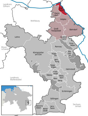
| Location of the community Grafhorst in the district of Helmstedt | ||
  |
||

Grafhorst is a municipality in the Helmstedt district in Lower Saxony, Germany. It is a member municipality of the Velpke joint municipality .
geography
Grafhorst lies between the Elm-Lappwald and Drömling an der Aller nature parks . Part of the community lies in the Drömling.

history
The community was first mentioned in a document in 1212. The origin of the name is not clear. The name part Graf- like other places in the area could have a Slavic origin, where grab or hrab stands for white beech . Likewise, the place name could have been taken over from a desolate Slavic village Grabow. The part of the name Horst indicates an elevated place in the settlement on the edge of the Drömling lowland area .
To the north of Grafhorst, west of today's road to Breitenrode , there was a fortification in the former marshland, which was probably an early medieval refuge . In 1898 an archaeological excavation took place on the site . An oval structure with a diameter of 45 × 65 m was discovered, which was once surrounded by a moat and a wall. Pieces of masonry, animal bones and pottery shards were found in the ground. After the end of the Second World War, until reunification, the place lay directly on the inner-German border , which was formed here by the Aller.
politics
advice
The council is the municipal representative of the community of Grafhorst. Every five years, citizens decide on the allocation of the nine seats in a general, direct, free, equal and secret ballot. In the 2016 municipal elections, the SPD received five seats, the CDU three and the Greens one seat.
mayor
The honorary mayor Klaus Wenzel was re-elected in 2011.
Economy and Infrastructure
traffic
Grafhorst is located directly on the federal highway 244 , which leads from Helmstedt to Wittingen .
Until 1945 Grafhorst had a station on the Wittingen – Oebisfelde railway line , and from 1953 to 1955 on the Schandelah – Oebisfelde railway line .
Religions
The Evangelical Lutheran Elisabeth Church is located in Grafhorst . On January 1st, 2017 the parish of Grafhorst merged with the parish of Danndorf to form the parish of Danndorf-Grafhorst. For the Catholic residents, the St. Mary's Church is in Velpke, five kilometers away .
Personalities
- Georg Wenzel, honorary citizen and politician
See also
Web links
Individual evidence
- ↑ State Office for Statistics Lower Saxony, LSN-Online regional database, Table 12411: Update of the population, as of December 31, 2019 ( help ).
- ^ Grafhorst - Das Dorf am Drömling , Helmstedt, 2001
- ↑ Results of the municipal council election 2016 Samtgemeinde Velpke
- ^ Official gazette of the Evangelical Lutheran Church in Braunschweig, edition of November 15, 2016, accessed on March 25, 2018.
Bahrdorf | Beierstedt | Danndorf | Frellstedt | Gevensleben | Grafhorst | Grass life | Groß Twülpstedt | Helmstedt | Jerxheim | Königslutter am Elm | Teaching | Mariental | Querenhorst | Räbke | Rennau | Schöningen | Söllingen | Süpplingen | Süpplingenburg | Velpke | Warberg | Wolsdorf
Municipality-free areas in the Helmstedt
Brunsleberfeld district |
Helmstedt |
Königslutter |
Mariental |
Schöningen