
Wittingen
| coat of arms | Germany map | |
|---|---|---|

|
Coordinates: 52 ° 43 ' N , 10 ° 44' E |
|
| Basic data | ||
| State : | Lower Saxony | |
| County : | Gifhorn | |
| Height : | 79 m above sea level NHN | |
| Area : | 225.1 km 2 | |
| Residents: | 11,421 (Dec. 31, 2019) | |
| Population density : | 51 inhabitants per km 2 | |
| Postcodes : | 29378, 29379 | |
| Primaries : | 05831, 05834, 05836, 05839 | |
| License plate : | GF | |
| Community key : | 03 1 51 040 | |
| LOCODE : | DE WTN | |
| City structure: | 26 districts | |
City administration address : |
Bahnhofstrasse 35 29378 Wittingen, Germany |
|
| Website : | ||
| Mayor : | Andreas Ritter (independent) | |
| Location of the city of Wittingen in the Gifhorn district | ||
  |
||

Wittingen is a town in the Gifhorn district in Lower Saxony .
geography
Geographical location
Wittingen is located in the northeast of the Gifhorn district on the state border with Saxony-Anhalt . The city lies between the Lüneburg Heath and the Altmark . Today's area of the city of Wittingen and the associated villages extends over an area of 225.09 square kilometers, of which 7.8% is settlement and traffic area. Closest cities are Gifhorn (25 km away), Wolfsburg (30 km), Uelzen (30 km), Celle (50 km) and Salzwedel (35 km) (all figures are rounded and straight lines). The ear flows through the urban area ; the district of Ohrdorf was named after her.
City structure
The city of Wittingen consists of the 26 districts:
history
Wittingen is founded
The first mention of Wittingen comes from a document from the year 781, in which the boundaries of the diocese of Hildesheim are described. Another early mention comes from a document from Charlemagne from 803, in which the boundaries of the new diocese of Halberstadt are named. However, from these sources it is not possible to infer the actual founding time of the place, because since there was already an area called Wittingau at that time , an earlier date of origin can be assumed.
middle Ages
Wittingen was not only a border town in the Middle Ages , but was also conveniently located on the border with the Altmark . The city was thus a trading and resting place for trade in an east-west direction. The Stephanus Church was built in the 9th century by the Halberstadt diocese. Wittingen had acquired town charter by the beginning of the 13th century and became a co-owner of the Lüneburg Mint . In 1340 the town came from Brandenburg into the possession of the Welfs of Celle. During the Hildesheim collegiate feud , Wittingen was almost completely destroyed in 1519. As a consequence, the construction of fortifications began.
Early modern times to modern times
.jpg)
In the course of the Thirty Years' War Wittingen was also badly damaged by tribute payments. In 1639 two Swedish regiments took up residence in the city. Most of the houses were destroyed by fire while they were there.
During the Seven Years' War Wittingen was occupied by the French. On April 12, 1792, at 8 p.m., a conflagration broke out in a house on the market, which, despite the almost imperceptible north-easterly wind, spread so quickly that 66 houses, without ancillary buildings, burned down within an hour. Most of the residents were already undressed and saved nothing but what they had on their bodies. Many were injured by the flames, two women and various cattle died. 387 people in need, including children and tenants, were present, as Pastor EH Küker announced in the "Hanoverian advertisements" on April 27 of that year.
The second occupation by the French took place in 1803 during the Napoleonic Wars .
Incorporations
On March 1, 1974, the communities Darrigsdorf, Erpensen, Gannerwinkel, Glüsingen, Kakerbeck, Lüben, Rade, Stöcken, Suderwittingen and Wollerstorf were incorporated. On the same day, the communities of Eutzen, Hagen bei Knesebeck, Mahnburg, Vorhop and Wunderbüttel were incorporated into the community of Knesebeck. Boitzenhagen, Plastau, Radenbeck, Schneflingen, Teschendorf and Zasenbeck were also incorporated into the municipality of Ohrdorf.
Finally, on April 1, 1974, the newly structured communities Knesebeck and Ohrdorf came to the city of Wittingen.
Population development
According to the Lower Saxony State Office for Statistics , 12,291 people lived in the city of Wittingen in 3745 buildings with a total of 5399 apartments and an average living space of 49.9 m² per person. Since the founding of the unified municipality, the number of inhabitants has grown steadily, both through positive natural population development and positive net migration. In 2005, 21.3% of the population were under 18 years old, 7.1% between 18 and 25, 27.0% between 25 and 45, 24.4% between 45 and 64, and 20.3% were 65 years old or older older. The unemployment rate averaged 11.3% (men: 9.4%, women: 14.0%). 2,247 people regularly commute out of the city, 1,745 in.
On December 31, 2019, the population was 11,421.
religion
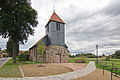
The Evangelical Lutheran St. Stephen's Church in the city center is the oldest church in Wittingen. Your parish belongs to the Lüneburg district of the regional church of Hanover . There are other Evangelical Lutheran churches in Wittingen districts. The St. Gabriel Church in Darrigsdorf (Wittingen) was built at the end of the 14th century as a rectangular Gothic field stone building. The Laurentius Church, built in 1235, was built as a fortified church and is a stone church in Ohrdorf.
St. Stephen's Church on Hindenburgwall is an independent Evangelical Lutheran Church .
The Catholic Church of Maria Königin , also called St. Marien , is the northernmost church in the dean's office in Wolfsburg-Helmstedt. It was built in 1972 on Schützenstrasse, designed as a prefabricated church with a free-standing bell tower. Before that there was an emergency church at Celler Strasse 12 since 1953. Today the parish also includes the Catholic church in Wesendorf .
The New Apostolic congregation in Wittingen was dissolved in 2012 and joined the congregation in Hankensbüttel , and the church building was sold. The first New Apostolic divine service in Wittingen took place in a hotel in 1926, and in 1975/76 a separate church was built at Spörkenstrasse 28.
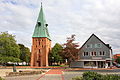
St. Stephen Church

Catholic Church
St. Gabriel Church in Darrigsdorf
Laurentius Church from 1235 in Ohrdorf


_IMG_9200.jpg)
_IMG_9276.jpg)
politics
Administrative affiliation
In its early days Wittingen belonged to Brandenburg . It was not until 1340 that the city came to Celle and thus to the Welfs . After the occupation by the French there was a new division of offices in 1810. Wittingen was located in the Lower Elbe département in the Kingdom of Westphalia and formed the 5th canton with 13 municipalities. Wittingen belonged to the Isenhagen district from 1885 to 1932 , which then became part of the Gifhorn district. In the course of regional and administrative reforms, the municipalities of Wittingen, Knesebeck, Schneflingen and the municipalities of Ohrdorf and Radenbeck merged to form the new town of Wittingen in 1974. Until January 31, 1978 Wittingen belonged to the administrative district of Lüneburg , until December 31, 2004 then to the administrative district of Braunschweig , which was dissolved as a result of an administrative reform at the end of this date.
City council
The council of the city of Wittingen consists of 28 council women and councilors. This is the specified number for a city with a population between 11,001 and 12,000. The 28 council members are elected by local elections for five years each. The upcoming term of office begins on November 1, 2016 and ends on October 31, 2021.
The full-time mayor Andreas Ridder (non-party) is also entitled to vote in the city council.
The last local election on September 11, 2016 resulted in the following:
mayor
- 1974–1985: Robert Leibelt
- 1985–1989: Paul Degenhardt
- 1990–1991: Wilfried Wolter
- 1991–1996: Lothar Schoss
- 1996–2001: Günther Schulze
- 2001–2002: Hans-Jürgen Schindler
- 2002–2019: Karl Ridder
The full-time mayor of the city of Wittingen has been Andreas Ritter (independent) since 2019. In the runoff election on June 2, 2019, he was able to prevail against the candidate of the Free Voters' Association with 60.83%.
coat of arms
The city's coat of arms shows a goalless, red castle in gold, with a blue lion on the battlements of the connecting wall between the two towers.
Town twinning
Wittingen maintains a city partnership or friendship with four cities and municipalities :
- Bismark , Saxony-Anhalt , Germany
- Koknese , Aizkraukles rajons , Latvia
- St. Margarethen , Styria , Austria
- Meadows , Burgenland , Austria

At the market in the old town

Monument Haus Kreyenberg from 1640
Celler Strasse, looking west

Sculpture Braumeister (1998 by Georg Arfmann)


_in_Wittingen_IMG_9229.jpg)
Clubs, associations and organizations
societies
- Kulturverein Wittingen eV
- Shooting Society of the City of Wittingen e. V.
- Riding u. Driving Association Wittingen e. V.
- Rowing club at the Hankensbüttel high school V.
- VfL Wittingen-Suderwittingen e. V.
- Stamp Association Wittingen e. V.
- Handels-, Gewerb- und Verkehrsverein Wittingen e. V.
- Allotment garden association Wittingen e. V.
- ADAC Wittingen e. V.
Organizations
- Wittingen volunteer fire department
- German Red Cross Wittingen
Culture and sights

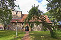
The Junkerhof in Wittingen

Museum in the Lüben district


- The Junkerhof was built in 1528 as an estate of the von dem Knesebeck aristocratic family , whose former castle was destroyed by the ducal troops at this point because of their raids around 1350. Today there is a historical exhibition of everyday objects from the region in the Junkerhof.
- St. Stephen's Church on the market
- The Park Am Junkerhof is a centrally located park at the hospital, with a pond and a sports field.
- The park Am Schönungsteich is located in the Nachtweide, not far from the town hall, the Heldenhain and the town hall.
- Epiphany Chapel in the Suderwittingen district with stained glass and etched flashed glass by Charles Crodel (Epiphany 1969)
- Lüben village with museum
- Knesebeck castle in the district Knesebeck
Economy and Infrastructure

Companies
- The Wittingen private brewery produces around 365,000 hl of beer a year with 100 employees.
- The municipal hospital has been part of the HELIOS Clinics Group since September 2013 .
- The H. Butting GmbH & Co. KG with headquarters in the district Knesebeck is one of the leading stainless steel processors in Europe.
- Neef + Stumme premium printing GmbH & Co. KG, medium-sized printing company
- The test site Ehra-Lessien is located with its northern part in Wittingen area.
traffic
The federal highway 244 runs from west to southeast through Wittingen.

Wittingen train station is on the Wieren – Wittingen – Gifhorn – Braunschweig railway (passenger services run approximately every two hours between Uelzen and Braunschweig) and the Celle – Wittingen small train , which is operated by the East Hanoverian Railways , OHE for short, as a freight and museum railway.
1909 was railway Wittingen-Oebisfelde the little train Wittingen-Oebisfelde opens AG. Until 1945, trains ran from the small train station in Wittingen-West to Oebisfelde (today in Saxony-Anhalt ), until 1974 to Rorien . This route is no longer in operation and officially closed. Around 1990 there were considerations to revive the route for a fast east-west freight railway (shortest route Magdeburg - Hamburg ). From 1909 to 1945 there was a connection of the Altmärkische Kleinbahn from Wittingen-West via the Wittingen-Süd stop to Diesdorf or Beetzendorf in the Altmark .
The Elbe Lateral Canal runs around 3.5 kilometers west of Wittingen . The port of Wittingen is located there .
Telephone prefixes
- The 05831 is the mainly used area code for Wittingen.
- The 05834 is valid in Knesebeck, Vorhop and Transvaal.
- The 05836 applies in Radenbeck and Zasenbeck.
- The 05839 is valid in Ohrdorf.
Others
The writer Hans Pleschinski writes in his books Ostsucht and Portrait of an Invisible Man about his youth in the German-German border region. He refers to his life in and around Wittingen in autobiographical passages.
Personalities
sons and daughters of the town
- Anna Forcke (1836–1904), superior in the Henriettenstift Hannover
- Ludwig Stackmann (1850–1903), district judge in Göttingen, Member of the State Parliament
- Friedrich Spitta (1852–1924), theologian
- Alfred Hildebrandt (1870–1949), aviation pioneer and writer
- Friedrich Bartels (1877–1928), writer and poet
- Hermann Link (1879–1964), lawyer
- Victor Oelkers (1881–1958), Senator, Mayor, 1947 to 1955 Member of the Lower Saxony State Parliament (DP / CDU)
- Walter Jankowsky (1890–1974), anthropologist and author
- Thilo Scheller (1897–1979), editor of the songbook Singend we want to march of the Reich Labor Service
- Fritz Winkelmann (1909–1993), lawyer, mayor of Wittingen, 1955 to 1963 Member of the Lower Saxony State Parliament (DP)
- Walter Torbrügge (1923–1994), prehistoric
- Hans Wittfoht (1924–2011), civil engineer
- Adolf Meyer (1929–2018), bookseller, elementary school teacher, school principal and local researcher; born in Erpensen
- Ernst Kalm (* 1940), agricultural scientist and university professor
- Wilfried Wolter (* 1948), Mayor of Wittingen 1990–91, 1990–94 Member of the Lower Saxony State Parliament (CDU)
- Klara Butting (* 1959), Protestant theologian
- Astrid Frohloff (* 1962), journalist and television presenter
- Bernd Fix (* 1962), computer security expert, member of the Chaos Computer Club
- Lars Nieberg (* 1963), show jumper
- Stephan Rother (* 1968), historian, writer, artist and comedian
- Kerstin Tack (* 1968), politician (SPD), member of the German Bundestag since 2009
- René Wegner (* 1983), soccer player
- Kevin Schulze (* 1992), soccer player
People related to the city
- Philipp Spitta (1801-1859), Lutheran theologian and poet, superintendent in Wittingen 1847-1853
- Georg Friedrich Heinemann (1825–1899), teacher and writer, died in Wittingen
- Karl Söhle (1861–1947), music critic and writer, teacher in Wittingen from 1883–1885
- Marion Lau (* 1947), from 1990 to 1994 member of the Lower Saxony state parliament (SPD), 2001–2014 district administrator for the Gifhorn district, lived in Wittingen and was a teacher and councilor there.
- Hans Pleschinski (* 1956), writer, grew up in Wittingen.
- Oliver Graf (* 1981), cultural manager and actor, grew up in Knesebeck and Vorhop.
- Max Langerhans (1851–1941), 1878–1888 country doctor in Wittingen, Low German writer; the city named a street, Dr.-Langerhans-Straße, after him.
literature
- City of Wittingen. A historical illustrated book . Compilation and text: Heimatverein Wittingen. Geiger, Horb am Neckar 1995, ISBN 3-89570-075-4
- The church in Wittingen . On behalf of the church council, ed. from the organ building association of St. Stephen's Church in Wittingen. Wittingen 1997
- Dierk Siebel: The Klosterhof, Freihof or Hofschultzenhof in Wittingen. The history of the farm and the Schultze family . Osnabrück 1993
- 50 years of Volksbank Wittingen eG. 1932-1982 . Wittingen 1982
- Lars Pennigsdorf: "Beer is wonderfully calming". The Wittingen private brewery in Lower Saxony has been in the hands of the Schulz-Hausbrandt family since 1935. (Company in Lower Saxony) . In: Hannoversche Allgemeine Zeitung v. September 4, 1999, p. 14
- Andreas Erhardt: The story of the little people. A series about the formation of the trade unions. History of the labor movement in the Wittingen area . Episode 1-5. In: Aller-Zeitung v. November 27, 1987, special pages
Web links
Individual evidence
- ↑ State Office for Statistics Lower Saxony, LSN-Online regional database, Table 12411: Update of the population, as of December 31, 2019 ( help ).
- ↑ a b Regional Report 2006. In: IHK Braunschweig. Archived from the original on July 10, 2007 ; accessed on March 7, 2018 .
- ↑ Rudi Fischer: 800 years Calvörde - a chronicle up to 1991. o.O. 1996.
- ↑ In detail: Matthias Blazek: Das Löschwesen in the area of the former Principality of Lüneburg from the beginnings to 1900. Adelheidsdorf 2006, p. 155 f., ISBN 978-3-00-019837-3 .
- ^ Federal Statistical Office (ed.): Historical municipality directory for the Federal Republic of Germany. Name, border and key number changes in municipalities, counties and administrative districts from May 27, 1970 to December 31, 1982 . W. Kohlhammer GmbH, Stuttgart / Mainz 1983, ISBN 3-17-003263-1 , p. 227 f .
- ↑ State Office for Statistics Lower Saxony, LSN-Online regional database, Table 12411: Update of the population, as of December 31, 2019 ( help ).
- ↑ In detail: Matthias Blazek: From the Landdrostey to the district government - The history of the district government of Hanover as reflected in the administrative reforms. Stuttgart 2004, ISBN 3-89821-357-9 .
- ^ Lower Saxony Municipal Constitutional Law (NKomVG) in the version of December 17, 2010; Section 46 - Number of MPs , accessed on December 30, 2014
- ^ Result of the 2016 city council election , accessed on September 13, 2016
- ^ Main statute of the city of Wittingen , accessed on December 30, 2014
- ↑ Helios takes over the clinic
- ↑ Songbook
Adenbüttel | Bar wand | Bergfeld | Bokensdorf | Brome | Calberlah | Dedelstorf | Didderse | Ehra-Lessien | Gifhorn | Groß Oesingen | Hankensbüttel | Hillerse | Isenbüttel | Jembke | Leiferde | My | Meinersen | Tired (of all) | Obernholz | Osloß | Parsau | Ribbesbüttel | Rötgesbüttel | Rüh | Sassenburg | Schönewörde | Sultry | Sprakensehl | Steinhorst | Tappenbeck | Tiddish | Tülau | Numbers | Vordorf | Wagenhoff | Wahrenholz | Wasbüttel | Wesendorf | Weyhausen | Wittingen
Unparished area in Giforn Giebel county