Ehra-Lessien
| coat of arms | Germany map | |
|---|---|---|

|
Coordinates: 52 ° 34 ' N , 10 ° 46' E |
|
| Basic data | ||
| State : | Lower Saxony | |
| County : | Gifhorn | |
| Joint municipality : | Brome | |
| Height : | 63 m above sea level NHN | |
| Area : | 56.09 km 2 | |
| Residents: | 1903 (Dec. 31, 2019) | |
| Population density : | 34 inhabitants per km 2 | |
| Postal code : | 38468 | |
| Area code : | 05377 | |
| License plate : | GF | |
| Community key : | 03 1 51 008 | |
| LOCODE : | DE E9S | |
| Community structure: | 2 districts | |
| Address of the municipal administration: |
Bromer Str. 1 38468 Ehra-Lessien |
|
| Website : | ||
| Mayor : | Jörg Böse ( CDU ) | |
| Location of the community Ehra-Lessien in the district of Gifhorn | ||
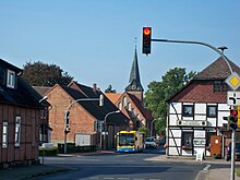
Ehra-Lessien is a municipality in the Gifhorn district in Lower Saxony .
geography
Ehra-Lessien is a member municipality of the Brome municipality . The joint municipality of Brome is located on the eastern edge of Lower Saxony and borders on Saxony-Anhalt . The municipality Ehra-Lessien consists of the districts Ehra (1,313 inhabitants) and Lessien (552 inhabitants), two kilometers to the west .
In the municipality there are large forest areas with the Bickelsteiner Heide and Malloh, which take up around 38 km² of the 56 km² municipal area. Ehra-Lessien is around 20 kilometers from Wolfsburg and Gifhorn . Neighboring communities are (counted clockwise from the north) Wittingen , Brome , Tülau , Barwedel , Sassenburg and Wahrenholz .
history
In the municipality there are a small number of finds from the Stone Age . Ehra was first mentioned in a document in 1309 as Ere . The place name can be proven neither as German nor as Wendish and could come from Germanic times. The original village shape was that of a Wendish round . Around Ehra and Lessien are the alleged desert areas Pölitz (towards Voitze), Boclo (towards Boitzenhagen) and Jaze (1.7 kilometers south of Ehra). In 1374 Ehra was given to the von Bartensleben family as a fief . The area was long in an exclave of the Mark Brandenburg . A customs house from this period was located north of Lessien. It was not until 1692 that the exclave came to the Principality of Lüneburg through an area swap that was regulated in the Wallstawe Treaty . According to a settlement register from around 1850, there were 29 farms at that time. In 1868 a large part of Ehra burned down.
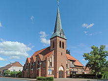
In 1903 Ehra received a church in the Wilhelminian style . 25 Ehraer died in the First World War. In 1929 Ehra and Lessien were merged into one community against the resistance of Lessien. North of Lessien, the Wehrmacht set up an approximately 1700 hectare training area in 1938 , which was used, among other things, to practice bunker blasting and - after the Second World War - to destroy weapons such as poison gas and as a training area for the German armed forces . On August 3, 1940 Ehra was one of the first civilian targets to be bombed by the British Air Force during World War II. Four people were killed. A total of 41 people from Ehra died in World War II.
After the Second World War, many refugees came to Ehra-Lessien, who from 1948 lived on the grounds of the military training area. A barracks settlement called "Platz" was set up there with its own elementary school . Soon after the Bundeswehr was founded in 1956, the settlement was dissolved and the area was used again for military purposes. The military training area was closed at the end of 2013; the residential buildings there were restored in 2015 as an emergency reception center for refugees and operated until 2016. For her integration initiatives, the then mayor Jenny Reissig was nominated for the German Engagement Prize.
In 1950 there were 1,333 residents in Ehra-Lessien. In 1984 there were 841 people in Ehra. In 1982 there were 40 farms there.
On July 1, 1970, the Ehra-Lessien community joined the Brome community. Ehra-Lessien has been part of the newly founded joint municipality of Brome since March 15, 1974.
politics
Municipal council
The council of Ehra-Lessien is composed of eleven council members, including the part-time mayor.
| CDU | SPD | total | |
| 2016 | 6th | 5 | 11 seats |
(Status: local election on September 11, 2016 )
mayor
Mayor is Jörg Böse (CDU).
coat of arms
The description of the coat of arms reads: In green, a silver eagle above a silver horseshoe.
Infrastructure
The test site Ehra-Lessien of Volkswagen AG is located north of Ehra in an extensive forest area . There is a high-speed track on the site - the so-called “Schnellbahn” with a length of 21 kilometers and two banked curves - on which a Bugatti Veyron set the record as the fastest production vehicle. The adjacent military training area of the Bundeswehr near Lessien was closed at the end of 2013 in accordance with the 2011 deployment concept . In 2015, in the course of the refugee crisis in Europe, it was converted into an emergency reception center for around 800 refugees. There is a primary school in Ehra.
Ehra-Lessien belongs to the Evangelical-Lutheran parish office Brome II of the parish association Brome-Tülau / Ehra in the parish of Wolfsburg-Wittingen. The church in Ehra was built in 1903, before Ehra belonged to the parish of Brome-Altendorf and Lessien to the parish of Jembke. It was not until 1955 that the church was given a patron saint, Archangel Michael, and thus a name. In addition to Ehra-Lessien, Boitzenhagen belongs to the catchment area of the church.
Ehra is on the B 248 , which connects Wolfsburg and Salzwedel . It is also connected to Wittingen and Gifhorn by country roads . The planned A 39 (Wolfsburg- Lüneburg ) should run between Ehra and Lessien and have a motorway junction there. Ehra is approached by VLG ( Brome- Gifhorn) buses . In addition, the VLG lines run to Ehra, mostly in school or weekend traffic.
Attractions
The landmark of the community is the Bickelstein , a 2.5 meter long ice age boulder that lies between Ehra and Boitzenhagen in the forest area of the Bickelsteiner Heide .
Sons and daughters of the church
- Carsten Meyer (* 1961), politician (Alliance 90 / The Greens)
Other personalities
- Giovanna Scoccimarro (* 1997), German judoka, lives in Ehra-Lessien
literature
- Johann Dietrich Bödeker: The land of Brome and the upper Vorsfelder Werder, history of the area at Ohre, Drömling and Kleiner Aller. JD Bödeker, Braunschweig 1985, ISBN 3-87884-028-4 , pp. 381-416.
Web links
Individual evidence
- ↑ State Office for Statistics Lower Saxony, LSN-Online regional database, Table 12411: Update of the population, as of December 31, 2019 ( help ).
- ↑ As of December 31, 2019, bulletin of the Brome municipality dated January 31, 2020; Counting of the total municipality
- ^ Johann Dietrich Bödeker: The land of Brome and the upper Vorsfelder Werder, history of the area at Ohre, Drömling and Kleiner Aller. Braunschweig 1985, ISBN 3-87884-028-4 , p. 383.
- ^ Johann Dietrich Bödeker: The land of Brome and the upper Vorsfelder Werder, history of the area at Ohre, Drömling and Kleiner Aller. Braunschweig 1985, ISBN 3-87884-028-4 , p. 408.
- ↑ The military training area was a new home for many refugees waz-online.de on July 16, 2013, accessed on August 16, 2013
- ^ Bundeswehr leaves the Gifhorn Gifhorner Rundschau district on June 19, 2013, accessed on January 7, 2014
- ^ Johann Dietrich Bödeker: The land of Brome and the upper Vorsfelder Werder, history of the area at Ohre, Drömling and Kleiner Aller. Braunschweig 1985, ISBN 3-87884-028-4 , p. 415.
- ^ Election result at samtgemeinde-brome.de , accessed on September 12, 2016
- ↑ http://www.ehra-lessien.de/02_07.php?nav=2
- ↑ http://www.kirche-wolfsburg-wittingen.de/wir_fuer_sie/gemeinden/ehra


