
Brome municipality
| coat of arms | Germany map | |
|---|---|---|

|
Coordinates: 52 ° 36 ' N , 10 ° 56' E |
|
| Basic data | ||
| State : | Lower Saxony | |
| County : | Gifhorn | |
| Area : | 203.89 km 2 | |
| Residents: | 16,415 (Dec. 31, 2019) | |
| Population density : | 81 inhabitants per km 2 | |
| License plate : | GF | |
| Association key : | 03 1 51 5402 | |
| Association structure: | 7 municipalities | |
| Association administration address : |
Bahnhofstrasse 36 38465 Brome |
|
| Website : | ||
|
Samtgemeinde mayor : |
Manuela Peckmann ( CDU ) | |
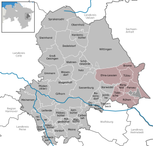
| Location of the joint municipality of Brome in the Gifhorn district | ||
  |
||

The joint municipality of Brome is a joint municipality in the district of Gifhorn in Lower Saxony . The seven communities Bergfeld , Brome , Ehra-Lessien , Parsau , Rühren , Tiddische and Tülau joined forces in 1974 to handle their administrative business. The joint municipality surrounds the uninhabited, municipality-free area Giebel in the eponymous Giebelmoor as an enclave . Another joint municipality Brome existed from 1965 to 1974.
geography
Geographical location
The integrated municipality of Brome is located on the south-eastern edge of the Lüneburg Heath and north of the Volkswagen city of Wolfsburg in the pentagon of Wolfsburg , Gifhorn , Wittingen , Salzwedel and Klötze . The altitude is 56 (in the southeast) to 111 m above sea level (in the northeast). In the south are the Vorsfelder Werder and east of it the Drömling , the north is called Bromer Land.
Neighboring communities
Clockwise, starting in the west, these are: Sassenburg , Wittingen , Wahrenholz , Beetzendorf , Klötze , Giebel (unincorporated area) , Grafhorst , Wolfsburg and Jembke .
Joint community structure
| The 7 member communities with their associated districts and settlements | ||||
|---|---|---|---|---|
| local community |
Residents (main residence) (December 31, 2015) |
Area: in km² |
Density in population / km² |
Districts / settlements |
| Bergfeld municipality | 894 | 10.60 | 84 | Mountain field |
| Spots brome | 3209 | 36.66 | 88 | Altendorf , Benitz , Brome, Wiswedel , Zicherie |
| Ehra-Lessien municipality | 2291 | 56.08 | 41 | Ehra, Lessien |
| Parish of Parsau | 1860 | 29.33 | 63 | Ahnebeck , Croya , Parsau, Kaiserwinkel |
| Municipality of Rüben | 5488 | 30.89 | 178 | Brechtorf , Eischott , Rüben |
| Tiddische community | 1256 | 16.78 | 75 | Hoitlingen , Tiddish |
| Tülau municipality | 1480 | 23.53 | 63 | Tülau- Fahrenhorst , Voitze |
history
A first joint municipality Brome was founded on July 1, 1965. It included the then independent communities Brome, Zicherie, Altendorf, Benitz, Wiswedel and Voitze. In addition, on January 1, 1970, the municipalities of Tülau-Fahrenhorst and Ehra-Lessien were added. On July 1, 1972, to the south of it, the joint municipality of Rorien was founded, which included the municipalities of Ränen, Tiddische, Bergfeld and Parsau (corresponding to today's municipality). The first Samtgemeinde Brome was dissolved on March 1, 1974, to be re-established on March 15, 1974, including the member communities of the former Samtgemeinde Rüßen. Brome remained the seat of the joint municipal administration, while Rühren received important schools and a large gym.
Population development
According to the Lower Saxony State Office for Statistics , 15,508 people lived in the integrated municipality of Brome in 4687 buildings with a total of 6078 apartments with an average living space of 46.0 m² per person. In 2007, 20.5% of the population were under 18 years old, 8.0% between 18 and 25, 29.3% between 25 and 45, 26.4% between 45 and 64, and 15.8% were 65 years old or older older. The unemployment rate was 6.9% on average (men: 4.6%, women: 10.3%). 5463 people regularly commuted out of the integrated community, 711 in.
politics

Joint council
The Council of the Samtgemeinde Brome consists of 30 women and Council councilors. The stipulated number for a parish with a population between 15,001 and 20,000 is usually 32 councilors. By resolution of the joint municipal council, this number was reduced by two council members. The 30 council members are elected for five years each by local elections. The upcoming term of office begins on November 1, 2016 and ends on October 31, 2021.
The full-time Mayor of the Joint Community, Manuela Peckmann (CDU), is also entitled to vote in the Council of the Joint Community.
The last local election on September 11, 2016 had the following result:
- CDU : 13 seats
- SPD : 9 seats
- Free community of voters SG Brome : 4 seats
- Greens : 3 seats
- Party-independent list SG Brome : 1 seat
Joint mayor of the municipality
Manuela Peckmann (CDU) received the absolute majority of the votes in the election for the mayor of the municipality on May 25, 2014. On November 1, 2014, she replaced Jürgen Bammel (non-party) in the office of mayor of the municipality.
particularities
The municipality of Brome is a sub-center , while the more populous municipality of Rorien does not have this status.
coat of arms
The description of the coat of arms reads: "Silver and red divided by tin cuts, below a blue-armored, striding, golden lion, above a growing red tower with a red hood".
Community partnerships
A city partnership has existed between the municipality of Brome and the French city of La Guerche-de-Bretagne since 1983 . Official visits, which the residents actively help shape, take place every year.
Culture and sights

Museums
Today the local history museum is housed in the main building of the castle. The focus is on “The old handicraft in Flecken Brome” with 17 fully equipped workshops in which the handicrafts are demonstrated on “active weekends”.
Buildings
The castle complex Burg Brome consists of the medieval smaller east wing and the elongated northern main wing. In between, the stair tower rises in the inner courtyard with a height of around 23 meters. The two-storey main building has the dimensions of 37 x 9 meters and from the 16th century. It has been restored with bricks in the old monastery format. In his basement there are cross vaults in two rooms .
The castle has been used as a local history museum since 1976, the focus of which is on the presentation of rural self-sufficiency and old crafts (including blacksmith, shoemaker, wood turner, carpenter) in the Bromer Land. Other offerings are a medieval herb garden, a basket beekeeping as well as restoration of a museum cafe.
Memorials


- Nazi memorials in Rüben
About one kilometer north of Rüben on the B 244 is a war cemetery with a memorial and a cross. During the Second World War, 76 dead who died in forced labor camps in the area were buried here. Most of them are Soviet prisoners of war who performed forced labor at the Volkswagen plant in nearby Wolfsburg .
In the cemetery in Rüben a plaque commemorates the fate of around 100 Polish and Soviet babies who died in 1944 and 1945. They came from a children's or nursing home for infants and toddlers of foreign forced laborers who worked in industry in Wolfsburg and on farms were used. The home existed on the outskirts of today's B 244 between Rorien and the bridge of the Mittelland Canal . Most of the children died because of the inadequate hygienic conditions and poor care.
- Memorial for a victim of the inner-German border
At Kreisstrasse 85 between Zicherie and Kaiserwinkel there is a memorial that commemorates the Dortmund journalist Kurt Lichtenstein . He was shot at this point by the GDR border troops on October 12, 1961 when he wanted to talk to farm workers in GDR territory, and died shortly afterwards in a GDR hospital.
Economy and Infrastructure
traffic
Two federal highways , the B 244 and B 248 , connect all neighboring territorial units and create good transport links to the A 2 / A 39 motorway . A dense network of regional and district roads, as well as community and farm roads connect the towns with one another.
The Mittelland Canal , which is important for inland navigation , runs right through the southern Samtgemeinde area. There is a mooring on the Rüben area .
Web links
Individual evidence
- ↑ State Office for Statistics Lower Saxony, LSN-Online regional database, Table 12411: Update of the population, as of December 31, 2019 ( help ).
- ↑ Regional report 2008 (PDF) IHK Braunschweig, accessed on March 31, 2014
- ^ Lower Saxony Municipal Constitutional Law (NKomVG) in the version of December 17, 2010; Section 46 - Number of MPs , accessed on September 16, 2014.
- ↑ Statute on the reduction of the number of councilors to be elected in the Brome municipality , accessed on December 31, 2014
- ↑ Results at samtgemeinde-brome.de , accessed on September 12, 2016
- ↑ Absolute majority for Manuela Peckmann. waz-online.de, accessed on June 15, 2014
Boldecker Land | Brome | Hankensbüttel | Isenbüttel | Meinersen | Papenteich | Wesendorf