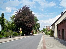
Ahnebeck
|
Ahnebeck
Parish of Parsau
Coordinates: 52 ° 32 ′ 31 ″ N , 10 ° 53 ′ 44 ″ E
|
||
|---|---|---|
| Height : | 64 m above sea level NN | |
| Residents : | 136 (Dec. 31, 2019) | |
| Incorporation : | July 1, 1972 | |
| Postal code : | 38470 | |
| Area code : | 05368 | |
|
Location of Ahnebeck in Lower Saxony |
||
Ahnebeck is a district of the municipality of Parsau in the east of the Lower Saxony district of Gifhorn .
geography
Ahnebeck lies on the northern edge of the Vorfeld Werder . It is separated from the nearby Croya by the ditch that leads east to the Drömling fen area and was previously called Antbeck or Anebek . Parsau is located immediately southwest of Ahnebeck. Ahnebeck extends along the B 244 ("Ahnebecker Straße").
Ahnebeck is around 64 meters above sea level and has 155 inhabitants. The place mainly consists of modernized farms and single-family houses, some of which were built after the Second World War. The surrounding area is rural with arable and mixed forest areas.
history
In 1341 a double murder took place on the Antbeck . The victims were two brothers from the Knesebeck family , the perpetrators belonged to the Bartensleben family , who resided on Wolfsburg . As an atonement , they had to erect a chapel at the scene of the crime and two altars in the Marienkirche in Salzwedel . In 1495 the von Knesebecks sold their property around today's Ahnebeck to the von Bartensleben. Since the border between the Principality of Lüneburg and the Principality of Braunschweig-Wolfenbüttel was between Ahnebeck and Croya, a customs post with an inn was set up at the crossing over the Ahnebeck.
As a place, Ahnebeck was first mentioned in 1624 as Ahnebergk . Ahnebeck was not built as a round like most of the surrounding villages , but as a street village . In 1850 there were twelve farms. Eight Ahnebeck men died in the hostilities of World War II, i.e. one fifth of the male population at the time.
In 1973 the restaurant was closed.
In 1858 there were 106 people in Ahnebeck. In 1939 there were 84 inhabitants in the village, in 1950 there were 173 because of the consequences of the influx of refugees after the Second World War. In 1985 the number had fallen to 123 and later rose again slightly as a result of immigration.
Until 1972 Ahnebeck belonged to the district of Helmstedt . On July 1, 1972, Ahnebeck was incorporated into the municipality of Parsau. The municipality of Parsau was henceforth part of the joint municipality of Rüsten and the district of Gifhorn. On March 1, 1974, the joint municipality of Rüßen was dissolved. On March 15, 1974, the Parsau community decided to join the Brome community.
Infrastructure and traffic
Ahnebeck belongs to the Evangelical Lutheran parish of Parsau.
Ahnebeck is served by buses on the Wolfsburg - Brome line every hour. Until 1974, passenger trains on the Wittingen – Ränen route stopped at the nearby Croya and Parsau stations.
literature
- Johann Dietrich Bödeker: The land of Brome and the upper Vorsfelder Werder, history of the area at Ohre, Drömling and Kleiner Aller. Braunschweig 1985, ISBN 3-87884-028-4 , pp. 479-492.
Individual evidence
- ↑ As of June 30, 2018, bulletin of the Samtgemeinde Brome from August 24, 2018; Counting of the total municipality
- ^ Johann Dietrich Bödeker: The land of Brome and the upper Vorsfelder Werder, history of the area at Ohre, Drömling and Kleiner Aller. Braunschweig 1985, ISBN 3-87884-028-4 , p. 479.
- ^ Johann Dietrich Bödeker: The land of Brome and the upper Vorsfelder Werder, history of the area at Ohre, Drömling and Kleiner Aller. Braunschweig 1985, ISBN 3-87884-028-4 , p. 481.
- ^ Johann Dietrich Bödeker: The land of Brome and the upper Vorsfelder Werder, history of the area at Ohre, Drömling and Kleiner Aller. Braunschweig 1985, ISBN 3-87884-028-4 , p. 491.
- ^ Federal Statistical Office (ed.): Historical municipality directory for the Federal Republic of Germany. Name, border and key number changes in municipalities, counties and administrative districts from May 27, 1970 to December 31, 1982 . W. Kohlhammer GmbH, Stuttgart and Mainz 1983, ISBN 3-17-003263-1 , p. 272 .
- ^ Johann Dietrich Bödeker: The land of Brome and the upper Vorsfelder Werder, history of the area at Ohre, Drömling and Kleiner Aller. Braunschweig 1985, ISBN 3-87884-028-4 , p. 521.


