Benitz (Brome)
|
Benitz
Spots brome
Coordinates: 52 ° 37 ′ 12 ″ N , 10 ° 54 ′ 27 ″ E
|
||
|---|---|---|
| Height : | 75 m above sea level NN | |
| Residents : | 85 (Dec. 31, 2019) | |
| Incorporation : | March 1, 1974 | |
| Postal code : | 38465 | |
| Area code : | 05833 | |
|
Location of Benitz in Lower Saxony |
||
|
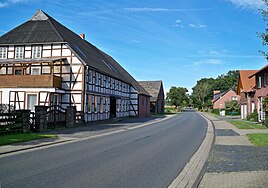
Dorfstrasse in Benitz, heading west
|
||
Benitz is a district of Lower Saxony patch Brome . It is the northernmost district in the joint municipality of Brome .
geography
Benitz is located three kilometers northwest of the town of Brome on the federal highway 244 . In the area there are mainly fields and small forest areas. The Ohre flows east of Benitz .
The Bromer districts of Altendorf and Wiswedel are about two kilometers southeast and three kilometers west, respectively. The Wittingen district of Radenbeck is four kilometers northwest. The closest place is Wendischbrome in Saxony-Anhalt , which is only one kilometer to the east.
history
Benitz was built as a Rundling . The name comes from Old Slavonic and means something like "place of Ben", where Ben means "slayer of enemies". In the 17th century the place was called Behnsen or Behnßen . In the east of Benitz the mill Gödchen Mühle (also Gätjen Mühle or Gödjen Mühle) was built, which was also used by the farmers from Wendischbrome. In 1872 there was a major fire in Benitz, as a result of which the round structure was largely abandoned and in 1880 the road through the town could be laid. In 1909 the Wittingen – Oebisfelde railway was opened, running west of Benitz. There was also the Benitz-Wiswedel station, which was operated by passenger traffic until 1974. A separate cemetery was set up in 1928 after the burials had previously taken place in Altendorf.
In 1919, 114 people lived in Benitz. In 1939 the number had dropped to 106; by 1950 it rose to 205 because of the influx of refugees. In 1984 the population was 111. In the same year there were eight farms there.
The municipality of Benitz became part of the joint municipality of Brome on July 1, 1965. On March 1, 1974 it was incorporated into the town of Brome and thus on March 15, 1974 part of the newly founded joint municipality of Brome.
Infrastructure
Benitz belongs to the Evangelical Lutheran parish office Brome I of the parish association Brome-Tülau / Ehra. The place is directly on the B 244. A district road leads to Wiswedel. Benitz is served by buses on the VLG line 163 ( Wittingen -Brome / Zicherie ) every two hours and by buses on the ZGB line 165 during school days.
literature
- Johann Dietrich Bödeker: The land of Brome and the upper Vorsfelder Werder, history of the area at Ohre, Drömling and Kleiner Aller. Braunschweig 1985, ISBN 3-87884-028-4 , pp. 246-258.
Individual evidence
- ^ Johann Dietrich Bödeker: The land of Brome and the upper Vorsfelder Werder, history of the area at Ohre, Drömling and Kleiner Aller. Braunschweig 1985, ISBN 3-87884-028-4 , p. 246.
- ^ Johann Dietrich Bödeker: The land of Brome and the upper Vorsfelder Werder, history of the area at Ohre, Drömling and Kleiner Aller. Braunschweig 1985, ISBN 3-87884-028-4 , p. 256
- ^ Federal Statistical Office (ed.): Historical municipality directory for the Federal Republic of Germany. Name, border and key number changes in municipalities, counties and administrative districts from May 27, 1970 to December 31, 1982 . W. Kohlhammer GmbH, Stuttgart and Mainz 1983, ISBN 3-17-003263-1 , p. 226 .


