Chicory
|
Chicory
Spots brome
Coordinates: 52 ° 34 ′ 18 ″ N , 10 ° 56 ′ 23 ″ E
|
||
|---|---|---|
| Height : | 70 m above sea level NN | |
| Residents : | 288 (Dec. 31, 2019) | |
| Incorporation : | March 1, 1974 | |
| Postal code : | 38465 | |
| Area code : | 05833 | |
|
Location of Zicherie in Lower Saxony |
||
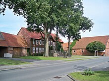
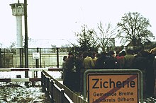
Zicherie is a district of the borough Brome in the east of Lower Saxony district Gifhorn . At the time of the inner-German border , it formed a well-known symbol of German division with the directly neighboring village of Böckwitz on the other side of the border .
geography
Zicherie is around 70 meters above sea level directly on the border with Saxony-Anhalt . Geologically it lies on the Calvörde plaice. The area is rural with fields and a wooded area in the south of the district . In the north of the Zicherie district lies the 90.7 meter high Büchenberg. Zicherie has 288 inhabitants.
The Klötzer district Böckwitz is just east of Zicherie, located therebetween, the narrow border trench. Brome is about three kilometers to the north. Kaiserwinkel is about six kilometers southwest, Croya three kilometers southwest. After Tülau-Fahrenhorst it is around four kilometers to the west.
history
Until World War II
Zicherie is originally a Wendish settlement. The name apparently comes from the Old Slavonic sékyra (German: ax). In 1563 the place was mentioned as Zichirie , in 1670 as Zecherey .
The place was built as a Rundling . In 1548 the place came from Fritz VII from Schulenburg to the aristocratic Bartensleben family . In the Thirty Years' War was destroyed more than half of the houses.
Until the 19th century, Zicherie was characterized by hall houses from Lower Saxony . The place became a cluster village through new buildings . In 1838 a brick factory was set up on the Büchenberg , the operation of which ceased in 1927 after the clay deposits were exhausted. In 1872 the "Schützenverein Zicherie-Böckwitz" was founded, in 1920 the "Zicherie Football Club". Until about 1946 there was a windmill northwest of the village . Today there are houses there, the street name is Mühlenweg. In the First World War 16 Zicherians died in combat operations, in the Second World War 22. Many Zicherians were related or related by marriage to people in the neighboring Böckwitz. The children from Zicherie attended the Böckwitz elementary school , the only restaurant with a large hall was also in Böckwitz. The football club of the two villages, on the other hand, was based in Zicherie.
Zicherie as a place on the inner-German border
With the establishment and expansion of the inner-German border, Zicherie and Böckwitz were separated despite their proximity. With the establishment of the Soviet occupation zone, the Zicherier students were no longer allowed to attend the Böckwitz school. In the first years after 1945 contacts were still possible, but made more difficult after the currency reform in 1948. In 1950 the joint rifle club of the two villages was even re-established. In 1952, the border was largely sealed off as part of the Germany Treaty , and some houses near the border in Böckwitz were demolished. Neighborly relationships were no longer possible. From a West German perspective, Zicherie and Böckwitz thus became symbols of the division of Germany. From then on, the shooting club only had members from Zicherie, while FC Zicherie had to stop playing in 1953 without the players from Böckwitz. In 1958, the day before the fifth anniversary of the uprising of June 17, 1953 , a boulder with the inscription " Germany is indivisible " was set up in Zicherie . The Trustees of Indivisible Germany built a "Zone Edge House". On June 17, 1959, thousands of people gathered in Zicherie to draw attention to the inhumanity of the border.

On October 12, 1961, the West German journalist Kurt Lichtenstein , coming from the area in the south of the former municipality of Zicherie, tried to speak to GDR farm workers. He was the first person to be shot dead by the GDR border troops after the Berlin Wall was built .
On July 28, 1964, the then Federal President Heinrich Lübke visited the place and the border fortifications.
Zicherie grew towards the B 244 and south after 1945 . Numerous new citizens were refugees from the neighboring villages across the border. In 1952 a school building was built. The school closed in 1969; from then on the students attended the school in Brome. The school building was converted into the "Haus Altmark " political education center. It was opened in 1977 under public ownership. From then on, conferences and youth camps took place here. After the border was opened, the house was closed in 1997.
At the edge of the forest south of Zicherie, sand and gravel have been mined by a concrete and mortar works since around 1970 . An inn on Böckwitzer Strasse and the two general stores were also closed.
In 1978 a hotel with a restaurant and a game reserve was set up around 400 meters south of the village on the federal road 244 on the edge of the forest . The restaurant was closed in 2016. In 1981 a visitor to the rifle festival was arrested by GDR border troops because he had crossed the border by almost 20 meters. He then had to serve a two-year prison sentence .
The dismantling of the wall between the two villages began just seven days after the fall of the Berlin Wall, and on November 18, the road from Zicherie to Böckwitz could be used again for the first time. The shooting club was founded for the third time. About 1.5 kilometers south of Zicherie, part of the border fortifications, expanded to include demonstration objects, remained on the east side as a "border educational trail". Hans-Dietrich Genscher planted a maple there in 1998 for the inauguration .
Unlike before the demarcation, there are no joint institutions today except for the Zicherie-Böckwitz shooting club, to which only eight Böckwitzers belonged in 2007. The students attend different schools, the fire brigades are not allowed to cross the state border.
Population development and administrative allocation
In 1811 Zicherie had 97 inhabitants. The number grew to 218 in 1939 and reached 464 in 1950, mainly due to the influx of refugees. In 1971 the number of inhabitants had fallen to 264. In 1984 there were 19 farms in Zicherie, 15 fewer than in 1971.
On July 1, 1965, the Zicherie community became part of the Brome community . On March 1, 1974, the municipality was incorporated into the town Brome, on 15 March 1974, it was with Brome part of the joint community Rühen extended Samtgemeinde Brome.
Infrastructure
Zicherie has a village community center and a cemetery with a chapel. The place belongs to the Evangelical Lutheran parish Brome I and to the Catholic parish of St. Michael Wolfsburg with a branch church in the nearby Parsau . The outdoor pool, the two grocery stores and the inn were closed.
Zicherie is just a little east of the B 244 , which ran along the inner-German border between Wittingen and Helmstedt until 1990 . By district roads it is connected to Tülau driving Horst (K26), Böckwitz (K27) and Kaiser angle (K85). Until 1974, the Tülau-Fahrenhorst station on the Wittingen – Oebisfelde railway line , which was around 2.5 kilometers west of Zicherie, was used by passengers. In 2013, Zicherie will be reached Monday to Friday by buses on VLG lines 163 and 165 from Brome.
literature
- Johann Dietrich Bödeker: The land of Brome and the upper Vorsfelder Werder, history of the area at Ohre, Drömling and Kleiner Aller. Braunschweig 1985, ISBN 3-87884-028-4 , pp. 295-314.
- Heinrich Thies : The way to Zicherie is long. The story of a divided village on the German-German border. Hoffmann & Campe, Hamburg 2005, ISBN 3-455-09529-1 .
Web links
- Photos from the border near Zicherie / Böckwitz 1979 with comparison photos 2004
- Eyewitness report from the opening of the border on November 16, 1989
- Report by Deutschlandfunk on Zicherie and Böckwitz 2007
- Report in the magazine Focus about Zicherie and Böckwitz 2009
- epd report on Zicherie and Böckwitz 2010 (fee required)
- Inner German border: Michael Latz's divided village on ndr.de, accessed on November 6, 2019
Individual evidence
- ↑ As of December 31, 2019, bulletin of the Brome municipality dated January 31, 2020; Counting of the total municipality
- ^ Johann Dietrich Bödeker: The land of Brome and the upper Vorsfelder Werder, history of the area at Ohre, Drömling and Kleiner Aller. Braunschweig 1985, ISBN 3-87884-028-4 , p. 300.
- ↑ Fritz Boldhaus: From eels to zone boundary. A little brome dictionary. Museum and Heimatverein Brome eV, Brome 2009, p. 114
- ^ Johann Dietrich Bödeker: The land of Brome and the upper Vorsfelder Werder, history of the area at Ohre, Drömling and Kleiner Aller. Braunschweig 1985, ISBN 3-87884-028-4 , p. 310.
- ^ Johann Dietrich Bödeker: The land of Brome and the upper Vorsfelder Werder, history of the area at Ohre, Drömling and Kleiner Aller. Braunschweig 1985, ISBN 3-87884-028-4 , p. 313.
- ^ Johann Dietrich Bödeker: The land of Brome and the upper Vorsfelder Werder, history of the area at Ohre, Drömling and Kleiner Aller. Braunschweig 1985, ISBN 3-87884-028-4 , p. 314.
- ↑ Here they took me away. In: Grenzwanderung. Braunschweiger Zeitung Spezial, Braunschweig 2009, pp. 20–21.
- ^ GDR border village: "We were all hugging each other ." Volksstimme.de from September 25, 2014, accessed on July 15, 2018
- ↑ Report by Deutschlandfunk on Zicherie and Böckwitz 2007 , accessed on June 5, 2011
- ^ A b Johann Dietrich Bödeker: The land of Brome and the upper Vorsfelder Werder, history of the area at Ohre, Drömling and Kleiner Aller. Braunschweig 1985, ISBN 3-87884-028-4 , p. 309.
- ^ Federal Statistical Office (ed.): Historical municipality directory for the Federal Republic of Germany. Name, border and key number changes in municipalities, counties and administrative districts from May 27, 1970 to December 31, 1982 . W. Kohlhammer GmbH, Stuttgart and Mainz 1983, ISBN 3-17-003263-1 , p. 226 .
- ^ Johann Dietrich Bödeker: The land of Brome and the upper Vorsfelder Werder, history of the area at Ohre, Drömling and Kleiner Aller. Braunschweig 1985, ISBN 3-87884-028-4 , p. 311.
- ↑ Line overview , accessed on January 9, 2013


