Stir
| coat of arms | Germany map | |
|---|---|---|

|
Coordinates: 52 ° 29 ' N , 10 ° 53' E |
|
| Basic data | ||
| State : | Lower Saxony | |
| County : | Gifhorn | |
| Joint municipality : | Brome | |
| Height : | 65 m above sea level NHN | |
| Area : | 30.89 km 2 | |
| Residents: | 5798 (Dec. 31, 2019) | |
| Population density : | 188 inhabitants per km 2 | |
| Postal code : | 38471 | |
| Area code : | 05367 | |
| License plate : | GF | |
| Community key : | 03 1 51 024 | |
| LOCODE : | DE 73I | |
| Community structure: | 3 districts | |
| Address of the municipal administration: |
At Schützenplatz 1a 38471 Rühren |
|
| Mayor : | Karl Urban ( CDU ) | |
| Location of the community of Rüsten in the district of Gifhorn | ||
Rüben is a municipality in the Gifhorn district in the east of Lower Saxony . The municipality of Rüsten is a member municipality of the integrated municipality of Brome and is located on the B 244 in the immediate vicinity of the city of Wolfsburg .
geography
Geographical location
The municipality of Rüsten is divided into the following districts:
Rüben lies in the historical landscape of the Vorsfelder Werder , an Ice Age Geestrrück . The municipality is located on the western edge of the Drömling low moorland . The town of Rüsten is surrounded on three sides by lowland areas. To the northeast is the Giebelmoor nature reserve with the community-free area Giebel . The Mittelland Canal runs through the east of the municipality. Part of the municipality boundary also forms the border between Lower Saxony and Saxony-Anhalt . Brechtorf is one kilometer south of the town of Rorien, Eischott from there two kilometers to the west. Parsau is five kilometers north, Kaiserwinkel seven kilometers northeast and Grafhorst six kilometers southeast.
Neighboring communities
The following cities and municipalities border on the municipality of Rüsten. They are called clockwise starting in the west:
history

The place Ränen was mentioned in a document as early as 1366 as Rughinghe . It was not until 1658's Rühen common. The meaning of the name is controversial. Presumably the name means "Salweidenstand". In addition to the other settlements in the Vorsfelder Werder, the village was founded in the 12th century as a Wendish round village . Many Wendish field names and the easily recognizable Rundling in the south of the village remind of this. For centuries, Rüsten belonged to the catchment area of Werder's main town, Vorsfelde , which was also a church until the post-war years of World War II . Thus, Rüben was Brunswick .
The Drömling played a major role for the Rhenish farmers, initially as a supplier of wood and cattle pasture. But it often happened that after heavy rainfall the hay swam on the flooded moor meadows. Therefore, logging was only possible in winter when the fen was frozen. The trees were cut down in parcels to produce fuel; Willow twigs were harvested as wicker material for baskets and boxes . As a result, the tree population never grew older than around ten years. The surrounding villages also had a right to logging in the Drömling, which is still reflected in field names such as "Tiddischer Drömling" or "Hoitlinger Drömling".
Agriculture on the fen areas was only made possible by the Rimpauschen moorland cultures , which were established in the 1930s. This happened mainly through the National Socialist Reich Labor Service . There was a camp of the Reich Labor Service in Ränen, which was located near the canal. From 1944 until the end of World War II, it was used as a warehouse for infants and young children of foreign forced laborers . A large proportion of the children there died in infancy due to neglect.
Until the 19th century, the Wipperteich was located near the district of Brechtorf . Until it was drained in 1841, it was the largest body of water in the Duchy of Braunschweig with an area of 200 hectares . It served fish farming and the operation of the Wipper mill .
After the end of World War II Rühen was up to the turn of BIP and customs port for freight by the GDR to Berlin.
Until the municipal reform in Lower Saxony on July 1, 1972, Rüben belonged to the Helmstedt district . The municipality of Rüßen, together with the partially newly cut municipalities of Tiddische , Bergfeld and Parsau, formed the Samtgemeinde Rorien in the district of Gifhorn, before the four communities became part of the Samtgemeinde Brome on March 15, 1974.
After the war, the community and in particular the town of Rühren grew very quickly. Initially it was refugees and displaced persons who built in the north of Rühens, but in the 1970s and 1980s it was mainly employees of the Volkswagen plant in Wolfsburg who built in the eastern part of the town. In the meantime, building areas have also been designated and developed in the west of Rühens. The population rose from 679 (1939) to 3820 (December 31, 2019). The population of the municipality of Rüsten has been over 5,000 since 2013, with an upward trend.
Railway history
Rühlen has a disused train station and track systems that were disused in 2005 and used by Kleinbahn Wittingen-Oebisfelde GmbH and, from 1944, by OHE ( Osthannoversche Eisenbahnen ). From 1909 onwards, the line connected Ränen with Oebisfelde and Wittingen . In 1944 a train east of the canal bridge was hit by a bomb. There were three dead. When the German-German border was drawn, train traffic to Oebisfelde came to a standstill in 1945. The route was initially used in a northerly direction (Wittingen). It had a certain significance for commuters to the VW plant in Wolfsburg, who had to take the bus to Wolfsburg from Rüsten. In 1974 passenger traffic was stopped. In 2008 part of the station area was designated as a commercial area, the other part as a residential area.
Incorporations
On July 1, 1972, the communities Brechtorf and Eischott were incorporated.
Population development
Due to its location in the Wolfsburg environs, the municipality of Rorien has an exceptionally strong population growth of 2.03% on average (period: 2011-2017) per year. Since 1970 the population has grown by more than 2.5 times.
| Municipality of Rüsten - population development since 1970 | ||||
|---|---|---|---|---|
| development | year | Residents | year | Residents |
 |
||||
| 1970 | 2,264 | 2010 | 4,890 | |
| 1975 | 2,470 | 2011 | 4,891 | |
| 1980 | 2,790 | 2012 | 4,968 | |
| 1985 | 3,305 | 2013 | 5,103 | |
| 1990 | 3,286 | 2014 | 5,355 | |
| 1995 | 4,093 | 2015 | 5,488 | |
| 2000 | 4,432 | 2016 | 5,479 | |
| 2005 | 4,804 | 2017 | 5,587 | |
| 2008 | 4,859 | 2018 | 5,621 | |
|
As of December 31, unless otherwise stated. Source 2008/09 and 2018: |
||||
religion
Until 1951, Rüben was not an independent parish , but a diaconate of the Evangelical Lutheran parish of St. Petrus in Vorsfelde; until 1958 the community was administered from St. Johannes (Vorsfelde III). As a result of the conversion of the former elementary school by Friedrich Berndt , Rühren received a church in the center of the village and was inaugurated in 1959. The stained glass windows designed by Helmuth Uhrig show scenes from the life of Paulus von Tarsus , the patron saint of the church. The Evangelical Lutheran parish of St. Paulus Rüßen has existed since 1958; The Evangelical Lutheran parish of Brechtorf-Eischott and, since July 1, 2012, the parish of Parsau also belong to the “Parish Association am Drömling”. The Rüsten church is also called St. Paulus Church, while the Brechtorf church is called St. Markus Church. In Eischott there has been a church prayer room since 2004 in the building of the former “cold house”, the former cold store of the village freezing community .
politics
advice
The council of the municipality of Rüsten has 17 members. The following parties and constituencies are represented:
- CDU - 7 members
- SPD - 7 members
- PUL (Party Independent List) - 2 members
- Bündnis 90 / Die Grünen - 1 member
(As of September 2016)
mayor
Karl Urban (CDU) has been the mayor since November 8, 2016.
coat of arms
The description of the coat of arms reads: In green a silver (white) three-leaved willow branch growing out of a silver (white) circular symbol.
Culture and sights
Nazi memorials

About one kilometer north of Rüben on the B 244 is a war cemetery with a memorial and a cross. 76 dead were buried here during the Second World War , who died in forced labor camps in the area. Most of them are Soviet prisoners of war who did forced labor at the nearby Volkswagen plant in Wolfsburg .
Since the 1930s there was a warehouse on the outskirts of the B 244 between Rorien and the road bridge over the Mittelland Canal . From 1944 onwards, like the Velpke care facility for foreigners , it served as a warehouse for infants and toddlers of foreign forced laborers who were employed in the Volkswagen factory in Wolfsburg and on farms. Most of the children died because of the inadequate hygienic conditions and poor care. Over 300 infants were killed.
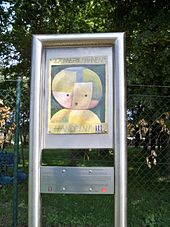
The doctor in charge, Hans Körbel , senior company doctor at the Volkswagen factory, was sentenced to death by hanging on June 24, 1946 at a war crimes trial in Helmstedt and was executed on March 7, 1947 in the Hameln penitentiary . A woman in charge of the home was also sentenced to death; her sentence was commuted to life imprisonment. Another woman was sentenced to five years in prison. Today a plaque commemorates the fate of the Polish and Soviet children in the cemetery in Rüllen with the inscription (in extracts):
- More than 100 Russian and Polish children who were victims of the Nazi tyranny in the children's camp in Rorien 1944–1945 rest here. When they were only a few days old, they were taken away from their mothers and died miserably.
leisure
- The Drömling is in the immediate vicinity and offers opportunities for walks, hikes and bike tours.
- There are 13 clubs in the village of Rorien, including the Kyffhäuser Kameradschaft Rorien. The Bulldog Club Drömling, which is dedicated to historical agricultural machinery , has existed since 1979 .
Sports
The greatest sporting success in the community was achieved by the Happy Beatles group on TV Jahn Rorien. In 2006 the young women became German champions in jazz and modern dance as a team, and in 2009 they became German runners-up.
Economy and Infrastructure
Rüben has several small craft businesses and a large number of retail businesses relative to its size. Doctors and pharmacy are also on site. From the former main branch of the economy , agriculture , there are only three full-time businesses and one part-time business .
Northeast of Rühen is the in 1977 in operation taken Waterworks Rühen the country - Stadtwerke Wolfsburg with a total of eleven deep wells, of which the city of Wolfsburg with drinking water is supplied from the Drömling. The treated drinking water is in the soft to medium hardness range . Around a third of Wolfsburg's drinking water is pumped here. The inhabitants of the municipality of Rüsten, however, get their drinking water mainly from egg waste.
The B 244 leads from Rüllen to Parsau and Grafhorst. A state road connects Rüben with Wolfsburg, a district road leads to Kaiserwinkel. Buses on line 160 run every 30 minutes or every hour to Wolfsburg on weekdays and every hour to Brome, while Ehra-Lessien and Bergfeld can be reached by line 162. The buses run less frequently on Saturday afternoons and on Sundays and public holidays.
The port of Rüßen on the Mittelland Canal - a Lände type - is used as a berth for ships of all kinds.
education
There is a kindergarten, a primary, a secondary and a secondary school in Ränen. Until September 2005, the secondary and secondary schools were combined in one building complex and known under the name HRS am Drömling . With the discontinuation of the orientation level in Lower Saxony, the secondary and secondary schools were separated by the Brome community amid massive protest. The secondary school under the name Johannes-Gutenberg -Schule Rorien - Hauptschule is now located in the building of the former orientation level. The Realschule gave itself the name Realschule am Drömling Rühren.
natural reserve
To the south of the Mittelland Canal, part of the municipality is designated as a nature reserve “ Politz and Hegholz ”. Parts of southern and eastern municipality is part of the conservation area "Drömling".
literature
- Johann Dietrich Bödeker: The land of Brome and the upper Vorsfelder Werder, history of the area at Ohre, Drömling and Kleiner Aller . Braunschweig 1985, ISBN 3-87884-028-4 , pp. 543-573.
- Günter Barthel u. a .: Rüsten, Brechtorf and Eischott in pictures . Horb am Neckar 2004, ISBN 3-89570-929-8 .
Web links
Individual evidence
- ↑ State Office for Statistics Lower Saxony, LSN-Online regional database, Table 12411: Update of the population, as of December 31, 2019 ( help ).
- ↑ a b as of December 31, 2019, newsletter of the Brome municipality of January 31, 2020; Counting of the total municipality
- ↑ GÜSt. Buchhorst und Rühren from ddr-binnenschifffahrt.de, accessed on June 26, 2018
- ^ Federal Statistical Office (ed.): Historical municipality directory for the Federal Republic of Germany. Name, border and key number changes in municipalities, counties and administrative districts from May 27, 1970 to December 31, 1982 . W. Kohlhammer GmbH, Stuttgart and Mainz 1983, ISBN 3-17-003263-1 , p. 271 .
- ↑ Population of the municipality of Rüsten , accessed on October 6, 2018
- ↑ History 1950 to 1969 on the Internet presence of the district of Helmstedt , accessed on February 23, 2018
- ^ Ernst Pauer: Church history and church art. In: Historical-regional excursion map of Lower Saxony, sheet Wolfsburg. Erhard Kühlhorn, Hildesheim 1977, ISBN 3-7848-3626-7 , explanatory booklet p. 123.
- ^ Website of the Parish Association , accessed on October 7, 2011
- ↑ Message on the website of the parish association ( Memento of the original from December 22nd, 2015 in the Internet Archive ) Info: The archive link has been inserted automatically and has not yet been checked. Please check the original and archive link according to the instructions and then remove this notice. , accessed December 20, 2015
- ↑ Local election on September 11, 2016
- ↑ Review in the Allerzeitung 2012 , accessed on October 6, 2012


