Ports in the Gifhorn district
| Ports in the Gifhorn district | |||
|---|---|---|---|
| Data | |||
| UN / LOCODE | DE 73K, DE ABL, DE WTN DE GIF, DE CLH, DE IBL DE 71I, DE OME |
||
| operator | Osthannoversche Umschlagsgesellschaft mbH and others | ||
| opening | from 1957/58 | ||
| Port type | Ports and Lands | ||
| Throughput | 300,000 t | ||
| Geographic information | |||
| place | Gifhorn district | ||
| country | Lower Saxony | ||
| Country | Germany | ||
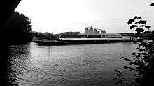
| Marina Abbesbüttel from the north (10/2011) | |||
| Coordinates | 52 ° 24 '29 " N , 10 ° 37' 20" E | ||
|
|||
The ports in the Gifhorn district consist of an inland port , two states and four marinas .
geography
The ports are located at seven spatially separate locations in the southern and eastern district of Gifhorn . They are located on the federal waterways Mittelland Canal (MLK) and Elbe Lateral Canal (ESK) at an altitude of 65 m above sea level. NN , the vertex posture of the canals. The Lände Rüsten lies in the far east of the district on the Mittelland Canal at an altitude of 56 m above sea level. NN , just before the border with Saxony-Anhalt .
The Gifhorn sports boat harbor is located on the Tankumsee , a 62 hectare former sand pit that was created when the ESK was built, at an altitude of 53.3 m above sea level. NN .
Map with all coordinates: OSM | WikiMap![]()
| Location: waters - km |
Port: | description | Quay length | Furnishing |
|---|---|---|---|---|
| MLK 227.3 south | Marina ⊙ | Marina Abbesbüttel | 100 m, quay wall | Water berths, 2 jetties, electricity, water, sanitary facilities, slip, (crane at the former loading point of the sand-lime brick plant) |
| MLK 233.3 south | Land ⊙ | Land Edesbüttel | 600 m, sponged | Berths for commercial vessels , electricity, water, plumbing, coffee kiosk, public transport, turning bay for pushing units up to 185 m length |
| MLK 234.9 south | Marina ⊙ | YC Hoffmannstadt | 230 m, sponged | 25 berths in the water, dry berths, slipway, water, electricity, sanitation, catering |
| MLK 255 north | Land ⊙ | Lände Rieten | 1,200 m, sponged | Berths for commercial shipping, electricity, water, catering |
| ESK (~ 5.0 West) | Marina ⊙ | Tankumsee pier | Footbridge | 125 berths in water, dry berths, for sailing and muscular vehicles, slipway, clubhouse |
| ESK 38.5 east | Port ⊙ | Wittingen harbor | 180 m, quay wall + 200 m, sponged |
Pumps, handling equipment for bulk goods , mobile excavators, silos, warehouse and outdoor storage areas, rail connection in two trains on both piers , berths with supply and disposal options |
| ESK 38.7 west | Port ⊙ | Wittingen sports harbor | 300 m, sponged | 70 berths in water, 20 dry berths, slipway, electricity, water, sanitation, catering |
history
The Mittelland Canal has been running in the southern and eastern district of Gifhorn since 1939, but initially there was no port of its own there. Due to the inner-German border , Ränen became a border crossing point for shipping with the GDR in 1956 . The former border station now houses restaurants. It was not until 1957/58 that the Abbesbüttel loading point was built, which was set up in the construction boom of the late 1950s and was in operation until the end of the 1990s. Mainly sand, gravel, cement and other building materials were handled. From the 1970s, the port of Wittingen was added to the west with the construction of the Elbe Lateral Canal, which was opened in 1976. The excavation of the sand required for the construction gave rise to the Tankumsee. In the course of further expansion work on the MLK, the Edesbüttel site was expanded in the 1980s. The Wittingen marina was completed in the late 1990s and when Abbesbüttel's mineral resources were also exploited and the limestone works had ceased operations, the remaining open-cast mining holes were also used for recreational purposes.
Commerce and infrastructure
Most of the port facilities in the Gifhorn district are used today for recreational boating and local recreation. Significant transshipment takes place only in the port of Wittingen. Around 300,000 t of mineral oil, forest and agricultural products as well as cellulose, animal feed and fertilizers are handled there in trimodal ship / rail / road transport.
traffic
The ports in Wittingen and Rüßen are accessible via local roads to the federal highway 244 . From Abbesbüttel, Edesbüttel and the Tankumsee it is closer to Bundesstraße 4 , the only unpaved roads lead to the Hoffmannstadt Yacht Club.
There is only a rail connection in Wittingen. A pull-out track from the Celle – Wittingen railway line leads there in two trains right to the pier.
There are public transport connections in Abbesbüttel and Edesbüttel around 250 m away, and at Tankumsee it is 700 m. It is 1.2 km from the Hoffmannstadt Yacht Club, 1.7 km in Rorien and 4.2 km in Wittingen to the nearest boarding points.
Web links
- Marina Abbesbüttel (15 high-resolution photos, possibly long loading time)
- Muskrat in the port of Abbesbüttel 1981


