Wasbüttel
| coat of arms | Germany map | |
|---|---|---|

|
Coordinates: 52 ° 25 ' N , 10 ° 36' E |
|
| Basic data | ||
| State : | Lower Saxony | |
| County : | Gifhorn | |
| Joint municipality : | Isenbüttel | |
| Height : | 67 m above sea level NHN | |
| Area : | 6.58 km 2 | |
| Residents: | 1785 (Dec. 31, 2019) | |
| Population density : | 271 inhabitants per km 2 | |
| Postal code : | 38553 | |
| Area code : | 05374 | |
| License plate : | GF | |
| Community key : | 03 1 51 037 | |
| Address of the municipal administration: |
Mittelstrasse 1 38553 Wasbüttel |
|
| Website : | ||
| Mayor : | Hartmut Jonas ( Alliance 90 / The Greens ) | |
| Location of the community of Wasbüttel in the Gifhorn district | ||
Wasbüttel is a municipality in the Gifhorn district in Lower Saxony . It is a member community of the Isenbüttel joint community .
geography
Geographical location
Wasbüttel is located between the Südheide and Elm-Lappwald nature parks in the triangle of the cities of Wolfsburg, Braunschweig and the district town of Gifhorn. The municipality is part of the Isenbüttel municipality , which has its administrative seat in the Isenbüttel municipality .
Neighboring communities
Neighboring communities are Isenbüttel , Calberlah and Meine .
history
The community was first mentioned in 1022 as Wilradesbutile . (For the place name broadcast see -büttel .) Wasbüttel belonged to the administration of Count Liudolf in Derlingau. Later the Brunons and the Guelphs ruled here . After the Guelph division of 1267, the area was added to the Principality of Braunschweig together with the other places of the Papenteich .
From 1428 to 1885 Wasbüttel was part of the Principality of Lüneburg , then part of the Lüneburg administrative district . The school chronicle of the Wasbüttel primary school shows that Wasbüttel was first connected to the telephone network in November 1904 .
Today there are only a few farms left in Wasbüttel; most Wasbüttel residents commute to the nearby Volkswagen factory every day .
Population development
Wasbüttel was already a cluster village-like complex: In 1489, 1 full farm, 6 half farms, 3 Kötner with land and 12 without land are registered.
In 1650 Wasbüttel consisted of 9 farms, 16 Kötnern and 1 Brinkitzer . In 1811 the first census showed 217 residents in over 30 residential buildings, in 1858 there were already 334 residents in 55 residential buildings, and in 1925 381 residents lived in 82 residential buildings.
After the end of the Second World War , many expellees settled in Wasbüttel: Compared to 1925, almost twice as many inhabitants (709) lived in Wasbüttel in 1950, and in 1968 there were already 213 residential buildings.
politics
Municipal council
The last municipal elections in 2016 resulted in the following composition of the municipal council (the results for 2011 in brackets) :
- CDU : 40.68% (55.11%) , 4 seats (6 seats)
- SPD : 34.10% (27.71%) , 4 seats (3 seats)
- Alliance 90 / The Greens : 25.21% (12.27%) , 3 seats (1 seat)
The turnout was 67.35% (64.96%) .
mayor
Hartmut Jonas (Bündnis 90 / Die Grünen) works as honorary mayor.
coat of arms
After Wilhelm Krieg presented the draft of today's coat of arms, it was accepted by the local council on July 27, 1978 and approved by the Gifhorn district on August 10, 1978.
The Wasbüttel coat of arms shows a silver mill wheel on a red background above a silver wavy band, above it two crossed silver rafters with ridge crossbars.
The symbols should remind of important events of the place and its geographical features. The two silver crossed rafters in the main shield stand for the events after the Second World War, when many expellees from the formerly German eastern areas settled in Wasbüttel. A situation arose in which long-established citizens and new citizens had to assimilate. This emergence of a new community is to be symbolized with the rafters shown. It is also often described as "all and everything under one roof".
With the help of the mill wheel in the heart of the coat of arms, the town's watermill is to be remembered, which was first mentioned in a document in 1485. It was located on the Hehlenriede , which crosses the old village street (today: Calberlaher Straße) at the eastern entrance to the village. Since the mill's drive shaft broke in 1905, it was shut down and finally completely demolished in the early 1970s.
With the help of the silver wave bar in the shield base, a reference to the geographical location on the Elbe Lateral Canal is made.
Culture and sights
Buildings
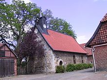
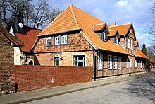
In the old town center there are still many old buildings, such as the chapel made of natural stones, the old school next to it and on the opposite side of the street an old half-timbered house where the village blacksmith used to live. The town center is also characterized by the school garden, which was managed by the teacher, and 4 other farms. Two of them stand out with their distinctive arches.
For years there was no agreement on what to do with the old school. Since it is a listed building, but in need of renovation, it could no longer be rented out. At the beginning of 2008 the community bought the old building from the real community and renovated it from 2009 to November 2010. The community office is now on the ground floor. All other rooms on the first and second floors including a furnished school room are available to the citizens and can also be rented for celebrations. On the orchard meadow on the southern edge of the village stands the straw bale house plastered with clay , which serves as a classroom for the Wasbüttel primary school.
The modern Peace Church of the Evangelical Free Church Community of Wasbüttel ( Baptists ) is located on Köweken .
Regular events
- Every two years committed citizens organize the Wasbüttel Christmas market. So far, 10,000 euros have been handed over to the Hanoverian association for children with cancer.
- Also every two years, the volunteer fire brigade organizes an approx. 30 km long bicycle rally where you can rediscover the area and answer tricky questions.
- Since 1992, the Isenbüttel youth organization has organized the southern district party on the Haselhof (Haaslop) on the first Saturday in May every year. With a beer and Bacardi bar, a vineyard and live music, the celebration attracted more than 2000 guests, both from the entire district of Gifhorn and from the surrounding districts. However, between 2010 and 2018 the number of guests steadily decreased. Because of this, the rural youth Isenbüttel decided that the southern district party should be held for the last time in 2019. The (for the time being) last southern district party was on May 4th, 2019.
- The Nabu Isenbüttel celebrates the blossom festival on the orchard meadow at the beginning of May. There is also the straw bale house of the Wasbüttel elementary school, which was built with the help of the vocational schools II Gifhorn, the technical school Braunschweig and many volunteers from Wasbüttel and Nabu.
- The Schützenverein Wasbüttel organizes the people's and rifle festival every spring.
- The sports week is held annually by the sports club (MTV).
Economy and Infrastructure
traffic
- Wasbüttel is to the west of the A39 motorway , which leads from Braunschweig to Wolfsburg , and east of the B4 federal road .
- The Elbe Lateral Canal branches off from the Mittelland Canal east of the municipality .
school
The Wasbüttel primary school is one of the most reliable primary schools and is currently attended by around 80 students.
Individual evidence
- ↑ State Office for Statistics Lower Saxony, LSN-Online regional database, Table 12411: Update of the population, as of December 31, 2019 ( help ).
- ↑ The history of the Wasbüttel primary school
- ↑ The history of the mills. Retrieved June 9, 2019 .


