Obernholz
| coat of arms | Germany map | |
|---|---|---|

|
Coordinates: 52 ° 45 ' N , 10 ° 37' E |
|
| Basic data | ||
| State : | Lower Saxony | |
| County : | Gifhorn | |
| Joint municipality : | Hankensbüttel | |
| Height : | 84 m above sea level NHN | |
| Area : | 37.82 km 2 | |
| Residents: | 820 (Dec. 31, 2019) | |
| Population density : | 22 inhabitants per km 2 | |
| Postal code : | 29386 | |
| Area code : | 05832 | |
| License plate : | GF | |
| Community key : | 03 1 51 019 | |
| Community structure: | 6 districts | |
| Association administration address: | Bahnhofstrasse 29 29386 Hankensbüttel |
|
| Mayor : | Werner Rodewald (community of voters) | |
| Location of the municipality of Obernholz in the Gifhorn district | ||
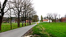
Obernholz is a municipality in the Gifhorn district in Lower Saxony .
geography
Geographical location
Obernholz lies between the Drömling and Südheide nature parks . The municipality belongs to the joint municipality of Hankensbüttel , which has its administrative seat in the municipality of Hankensbüttel .
Neighboring communities
In the south and west, Obernholz borders on the municipalities of Sprakensehl , Dedelstorf and Hankensbüttel , in the east on the city of Wittingen and in the north on the district of Uelzen .
Community structure
The community is divided into the following places:
Bottendorf , Steimke , Schweimke , Wettendorf , Wentorf and Wierstorf .
history
Incorporations
On March 1, 1974, the formerly independent communities of Bottendorf, Schweimke, Steimke, Wentorf, Wettendorf and Wierstorf merged to form the new community of Obernholz. The name comes from the plot of land called Obere Holz in the center . Obernholz originated from this name .
Population development
|
¹ census result
politics
Municipal council
The local council from Obernholz consists of nine councilors.
| Community of voters | Escaped | Others | SPD | total | |
| 2006 | 7 (81.8%) | 2 (18.2%) | 0 (0%) | 0 (0%) | 9 seats |
| 2011 | 8 (91.2%) | 0 (0%) | 1 (8.8%) | 0 (0%) | 9 seats |
| 2016 | 6 (70.7%) | 0 (0%) | 1 (12.4%) | 2 (12.8%) | 9 seats |
last local election on September 11, 2016
mayor
The honorary mayor Werner Rodewald was elected on September 9, 2001.
coat of arms
The green color of the upper left half of the coat of arms embodies the forest, meadow and farmland. The black of the lower right half is the moorland. Streams and watercourses are symbolized by the silver sloping wave beams. The upper half of the golden wheel (cartwheel) is reminiscent of the old military road that once ran through the area and of the local handicraft businesses. The lower half of several water mills (paddle wheel). The number of shovels indicates the six districts of the municipality of Obernholz. The silver crane in the black field (moor) symbolizes the large and proud wading birds that once and still populate the moor and meadows.
Economy and Infrastructure
Buildings
- There are ten wind turbines in the community with a height of up to 100 m and a rotor diameter of 50 m. On February 4, 2011, a system was damaged in a fire.
- One kilometer northwest of Wettendorf is a radar tower of the former low-flying reporting and control service of the Air Force .
Streets
- Obernholz is located north of the federal highway 244 , which comes from the northwest via Helmstedt to Elbingerode .
- The district roads K 11, K 12, K 13 and K 14 run through the municipality
Waterways
The eastern border of the municipality is the Elbe Lateral Canal .
Web links
Individual evidence
- ↑ State Office for Statistics Lower Saxony, LSN-Online regional database, Table 12411: Update of the population, as of December 31, 2019 ( help ).
- ^ Federal Statistical Office (ed.): Historical municipality directory for the Federal Republic of Germany. Name, border and key number changes in municipalities, counties and administrative districts from May 27, 1970 to December 31, 1982 . W. Kohlhammer GmbH, Stuttgart / Mainz 1983, ISBN 3-17-003263-1 , p. 227 .
- ↑ http://www.az-online.de/nachrichten/landkreis-gifhorn/wittingen/steimke-windrad-brennt-1110908.html


