Wentorf (Obernholz)
|
Wentorf
Community Oberholz
|
|
|---|---|
| Coordinates: 52 ° 44 ′ 47 " N , 10 ° 39 ′ 15" E | |
| Height : | 20 m above sea level NN |
| Residents : | 118 (Sep 1, 2016) |
| Incorporation : | March 1, 1974 |
| Postal code : | 29386 |
| Area code : | 05832 |
|
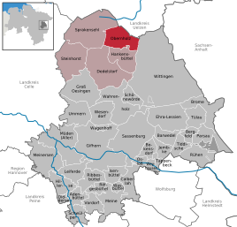
Location of Wentorf in the Gifhorn district
|
|
Wentorf is a district of the municipality of Obernholz , district of Gifhorn in Lower Saxony in the southern part of the Lüneburg Heath , near the border with Saxony-Anhalt.
Geographical location
Wentorf is located about 30 km south of the city of Uelzen , but administratively belongs to the Gifhorn district . The place is located between the Südheide Nature Park and the Elbufer-Drawehn Nature Park . Wentorf is part of the municipality of Obernholz and is located on the eastern edge of the municipality. The closest medium- sized centers are Gifhorn , Celle and Uelzen.
history
Due to its geographical location as the intersection of three Germanic districts and three dioceses , Wentorf was a border village hundreds of years ago. Fortifications such as the dam castle were built for this purpose. The remains of the ring wall system lie on a sand dune at the confluence of the Ise and Gosebach rivers, 1 km northeast of Wentorf.
On March 1, 1974, Wentorf was incorporated into the new municipality of Obernholz.
Clubs, associations and organizations
organization
Wentorf volunteer fire department
Economy and Infrastructure
Streets
District road 14 runs through Wentorf .
Individual evidence
- ^ Federal Statistical Office (ed.): Historical municipality directory for the Federal Republic of Germany. Name, border and key number changes in municipalities, counties and administrative districts from May 27, 1970 to December 31, 1982 . W. Kohlhammer GmbH, Stuttgart and Mainz 1983, ISBN 3-17-003263-1 , p. 227 .

