
Südheide Nature Park

Heathland of the nature park during the heyday
|

Heidschnucken in the Misselhorn Heath
|


The Südheide Nature Park has been designated as a German nature park worthy of protection since 1964 in the Südheide , which is much more extensive to the west and east . It is characterized by large areas of forest and heathland . Five percent of its area is designated as a nature reserve and 90 percent as a landscape protection area.
location
The approximately 480 km² Südheide nature park is located in the southern Lüneburg Heath , in the northeast of the Celle district and begins a few kilometers north of Celle . It extends from there between the city of Bergen in the west, over Faßberg in the north and Weyhausen and Steinhorst in the east. Other heathlands in the nature park are Eschede , Hermannsburg , Müden (Örtze) , Unterlüß , Eldingen and on the edge of the nature park Winsen (Aller) .
The nature park only takes up about one sixth of the area of the main natural spatial unit Südheide . North-northwest of the Südheide Nature Park, around 18 km away, is the Lüneburg Heath Nature Park around the northwestern part of the Hohe Heide , in the center of which is the Lüneburg Heath Nature Reserve . To the east-northeast, about 26 km away, is the Elbhöhen-Wendland nature park with landscapes of the Ostheide .
Origin and history

The landscape of the nature park was shaped by the Ice Age . The gravel and sands deposited during this time form a wavy to gently hilly terrain. It is made up of sand surfaces , ground moraine plates and terminal moraine remains .
Coniferous forests were planted on the nutrient-poor sand areas of the Geest in the area of today's nature park around the 18th and 19th centuries. Earlier only the loamy soils were used as arable soils. These usage conditions explain the sparsely populated area with scattered settlements and therefore also the few traffic routes. With the introduction of mineral fertilizers in the 19th century, the barren sandy soils could also be used for agriculture. As a result, the formerly extensive heathland areas were largely converted into agricultural land.
Between 1863 and 1994, the versatile kieselguhr was mined and processed at five locations in the area of the nature park .
description
The Südheide Nature Park is part of one of the largest contiguous forest areas in Germany, mainly characterized by pine and spruce . Parts of the earlier royal logs, such as B. the Lüßwald in the northeast of the nature park, still have old beech and oak stocks.
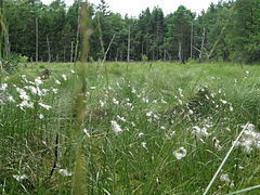
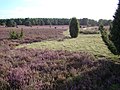
Special part of the landscape are the 525 ha heathland , which almost exclusively with the heather ( Calluna vulgaris are covered). The bell heather ( Erica tetralix ) can only be found sporadically on the more humid locations . They are remnants of the extensive heathland that stretched between Celle and Lüneburg until the end of the 19th century . These are now secured as a nature reserve or as part of the European NATURA 2000 protected area system.
The district of Celle in the eastern center of Lower Saxony is responsible for the nature park founded in 1964 . The entire park area is almost entirely designated as a landscape protection area. With 43,775 hectares, the Südheide is the largest protected landscape area in Lower Saxony. There are several nature reserves in the Südheide Nature Park , some of which are of European importance. The largest is the NSG Lutter (Lachte-Lutter area) with a total of 2435.3 hectares. Other large nature reserves in the nature park are the Weesener Bach with 348 hectares, the heather areas of the middle Lüß plateau (Tiefental) with 293 hectares and the Bornriethmoor with 115 hectares Südheide today consists of 65 percent forest landscape. The park administration tries to preserve the heathland, among other things by grazing with heather sheep herds . Where that is not enough, machines are sometimes used to plow the heath. Various regional and international hiking trails lead through the area. Among other things, the European long-distance hiking trail E1 , the Heidschnuckenweg and the German Way of St. James Via Scandinavica .
- Middle Lüß plateau in the NSG Heide area
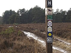
Signpost of the hiking trails
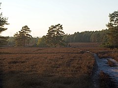
Hikers in the NSG Heideflächen middle Lüßplateau
.jpg)

beekeeping
Like other parts of the Lüneburg Heath, the Südheide Nature Park is a traditional area of heather beekeeping , where heather honey is obtained. During the heather bloom, beekeepers migrate from more distant areas to the heather areas of the Südheide with their bee colonies . They were partly set up in fixed apiaries . The Lüneburger Stülper , a beehive in the shape of a bell, or the square Kanitz basket, both made of straw, which are sealed with a mixture of cow dung and peat, can be found here very rarely . This dwelling use beekeepers still to comb honey to harvest. In the mid-1920s came the so-called Kanitz baskets, which are named after the beekeeper and teacher Kanitz (1815-1899). He found out that the bell cage used at the time did not give beekeepers enough opportunity to lead the colonies.
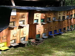
The old basket shape for the bee houses has been abandoned because today's boxes made of wood or plastic are easier to use. The plastic magazine hives that are common in northern Germany today are simply placed on the heather during the flowering period.
- beekeeping

Apiary at the edge of the forest with: modern plastic boxes, Kanitz baskets, a Lüneburg cover and wooden boxes (from left)
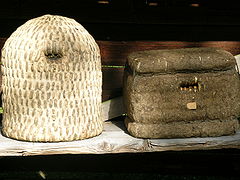
Lüneburger Stülper (left) and Kanitz basket made of straw
Beehives made of wood
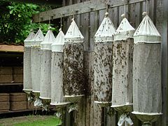
Swarming sacks with a captured swarm of bees hang in a bee fence


Geography, fauna and flora
Geography and flora
The nature park is drained by the Örtze , with its tributaries Schmarbeck , Sothrieth , Wietze , Weesener Bach and Bruchbach , and by the Lachte with its tributaries Aschau and Lutter , southwards to the Aller . Numerous endangered plant and animal species such as otters , brown trout and river pearl mussels have their habitat in the streams, some of which are protected . The origin of the heather streams is often in idyllic moors . The Örtze is a popular river with canoeists because of its meander . For reasons of nature conservation, however, the access is limited seasonally. Above Müden (Örtze) there is a year-round traffic ban. The Lutter, with its tributaries Schmalwasser and Ahrbeck, and the Lachte, which flow in the eastern part of the Südheide Nature Park, form with a total of around 2,450 hectares, a widely branched river system that has been designated as a nature reserve. As a near-natural area of the Südheide, the area is of particular importance for nature conservation. Not only the streams themselves as a habitat for fish and otters, but also adjacent floodplain and swamp forests , moors, swamps and spring areas, in which bird species such as black stork , white-tailed eagle , crane and rare flowing water dragonflies, including the endangered scarlet dragonfly and the endangered small one Blue arrow are native. Over 160 endangered animal and plant species live on and in these heather streams. The last occurrences of the north-western European freshwater pearl mussel in the Lutter are particularly significant and place particularly high demands on the quality of their habitat. According to the EU Habitats Directive , this is a type of special interest. The Federal Agency for Nature Conservation, the State of Lower Saxony and the districts of Celle and Gifhorn have been promoting this major nature conservation project since 1989.
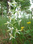
One of the highest elevations and a popular vantage point in the nature park is the Haußelberg at 119.1 m above sea level . There are still some intact raised bogs. First and foremost the protected Bornriethmoor near Oldendorf, but also near Hetendorf and Müden / Örtze there are still small bogs with a population of protected plants such as sundew , moor lily , knotweed or cotton grass , and also rare orchids such as broad-leaved orchid , the spotted orchid , the white forest hyacinth and the broad-leaved stendellum . There is a population of the narrow-leaved thread gentian in the Südheide Nature Park . It belongs to the gentian family . Cicendia filiformis is rarely found in Germany. It was classified in the Red List of Plant Associations in Category 2 = "highly endangered". There is probably only one other proven place in Lower Saxony in which the thread gentian grows.
- Protected plants in the Südheide Nature Park
Cotton grass in the high moor near Hetendorf

Middle sundew ( Drosera intermedia ) in a bog near Hermannsburg

Lung gentian ( Gentiana pneumonanthe )

Knotweed ( Bistorta officinalis )
White forest hyacinth in the forest near Müden (Örtze)

Spotted orchid in the forest near Müden (Örtze)

Broad-leaved Stendelwurz in Müden (Örtze)
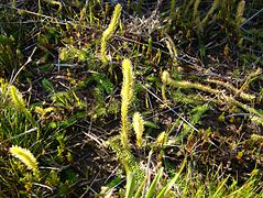
Swamp club moss ( Lycopodiella inundata )

Common devil bite ( Succisa pratensis )
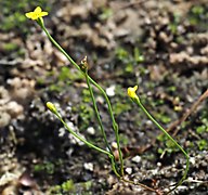
Thread gentian ( Cicendia filiformis )

Gail Shrub ( Myrica gale )


_16.jpg)
.jpg)


.jpg)

.JPG)
@20170807_01.jpg)
.jpg)
fauna

In 1872 a wolf was seen and shot for the last time in the Lüneburg Heath, in "Becklinger Holz" . After a wolf was spotted for the first time in 2006 on the approximately 50 km² large, wild and species-rich testing area of the Rheinmetall Waffen Munition GmbH company and in 2007 a first photo proof of an individual animal was made, a pack has now established itself in the Unterlüß area . as had been suspected in 2013 after further sightings. Particularly rare animal species and numerous other wolf offspring (in Munster between 2012 and 2014 already 17 young animals) also support the Munster and Bergen military training areas , which are also connected to the Lüßwald through forest, meadow and heather areas .
Due to the rewetting of the moors, in connection with the Lower Saxony crane protection program, it has been possible to revive the extinct population of the gray crane . After more than twenty years of vacancy, two crane pairs appeared again in the district of Celle in 1986 for the first time. The gray crane could therefore be downgraded from level 1 (critically endangered) to level 2 (endangered) on the red list of breeding bird species endangered in Lower Saxony in 1995 , and to level 3 (endangered) in 2002. In 2007 he was removed from the red list.
Population development of the gray crane in the LK Celle
| year | Territory pairs | Breeding pairs | Fledglings | year | Territory pairs | Breeding pairs | Fledglings | |
|---|---|---|---|---|---|---|---|---|
| 1986 | 2 | 1 | 0 | 1999 | 29 | 20th | 17th | |
| 1987 | 2 | 2 | 2 | 2000 | 34 | 23 | 23 | |
| 1988 | 3 | 2 | 2 | 2001 | 38 | 24 | 28 | |
| 1989 | 3 | 3 | 1 | 2002 | 41 | 26th | 22nd | |
| 1990 | 3 | 3 | 5 | 2003 | 42 | 29 | 31 | |
| 1991 | 5 | 4th | 5 | 2004 | 51 | 36 | 33 | |
| 1992 | 6th | 5 | 7th | 2005 | 54 | 46 | 30th | |
| 1993 | 6th | 6th | 8th | 2006 | 55 | 47 | 51 | |
| 1994 | 9 | 9 | 7th | 2007 | 53 | 44 | 49 | |
| 1995 | 12 | 11 | 11 | 2008 | 61 | 48 | 50 | |
| 1996 | 16 | 12 | 15th | 2009 | 63 | 51 | 50 | |
| 1997 | 16 | 13 | 19th | |||||
| 1998 | 22nd | 19th | 18th |
Attractions
The largest still contiguous heather areas are located near Hermannsburg ( heather areas middle Lüß plateau , Tiefental) and between Müden (Örtze) and Unterlüß near Oberohe. Further heather areas can be found near Müden / Örtze ( Wietzer Berg , 102 m) near Schmarbeck (juniper forest), near Haußelberg (118 m), near Lutterloh and near Gerdehaus (Ritterheide). (This heather area got its name because of the nearby site of a knight's grave from the 2nd century). Three large herds of Heidschnucken still live in the region. One herd each in Niederohe, one in Schmarbeck and one in Hermannsburg. They keep the heather short by their browsing and devour the emerging pines and birches. The juniper park near Schmarbeck is a heather covered with old junipers . On the Wietzer Berg south of Müden / Örtze, the Lönsstein memorial stands in a heather area , commemorating the heather poet Hermann Löns . There is a fork in the road between Hermannsburg and Müden / Örtze, from which paths branch off in seven different directions. In September, you can at Starkshorn (near Eschede) the deer rutting observed. Every year two herds of almost 200 hinds gather on the meadows.
- Worth seeing in the nature park

Heidschnuckenstall in Niederohe

Herd of Heidschnucken near Schmarbeck

Seven-armed signpost at Hetendorf

Lönsstein on the Wietzer Berg near Müden (Örtze)

Heath in Tiefental
Heathland on the Haußelberg

Rutting season at Starkshorn

Heathland on the Wietzer Berg near Müden (Örtze)


Landscape picture and landscape experience
The Danish poet Jens Immanuel Baggesen wrote in 1794 on the occasion of his trip through Germany when he came through the area of today's Südheide:
"P.56
1st Monday (1. 9.1794).
[...] The actually dreary and sad part of the way from Lüneburg to Celle begins here. Sand, heath and moor, surrounded by everlasting fir and spruce forests, is everything you discover. Not a single roof - no water - not a person - not an animal - not even the air - if I take out a terrible number of ravens.
P.57
Our vehicle rolled over this quiet, dead surface so lightly and quietly that you could hear your own breath. "
Natural disasters
Niedersachsenorkan 1972
On November 13, 1972, the Quimburga hurricane swept over the Südheide Nature Park and left large storm damage in the forest areas through fallen trees. Because of the enormous damage that the hurricane caused in Lower Saxony, the event was referred to as the Lower Saxony Orcan.
Forest fire disaster in 1975

The fire in the Lüneburg Heath in 1975, the largest forest fire in the history of the Federal Republic of Germany, also affected the area of the Südheide Nature Park. One of the sources of fire developed on August 9, 1975 at 12:50 p.m. from a fire in the Unterlüß / Schmarbeck area . The next day at 12:30 p.m., a forest fire was reported between Eschede and Oldendorf near the town of Queloh (municipality of Eschede). The fire spread quickly in the pine monocultures. On August 10, the Lüneburg district president declared the state of the disaster. The local fire brigades under the direction of the senior district director were no longer in control of the situation. It was only when the Bundeswehr finally took over the command that fire fighting was professionally coordinated. On August 18, the worst of the fires were under control and the disaster alert was ended. Around 6,000 hectares of forest, bog and heathland were burned in the area of the nature park.
Consequences for the nature park
When reforesting the forest areas destroyed by the storm and the forest fire, a departure from the pine monocultures was initially considered. More deciduous trees ( oak and beech ) should be planted. Soil investigations showed, however, that deciduous forest was only possible in very few locations because of the barren sandy soil. The forest fire also destroyed much of the existing humus soil. At the edges of the forest, larches were sometimes planted to serve as fire protection. Otherwise, the burned areas were reforested with pine trees .
In order to be better prepared for future forest fires, paved access roads were created in the nature park exclusively for fire engines. Extinguishing water extraction points were set up at existing lakes, fish ponds or gravel pits. In addition, new extinguishing water ponds were created in the Südheide . Where there was no running water to draw water from, heating oil tanks, each with between 20,000 and 100,000 liters of water, which had been used as extinguishing water storage tanks, were placed in the ground.
See also
Web links
- Presentation of the Südheide nature park by the district of Celle
- Brochure district of Celle, with detailed map (p. 14 and 15) (PDF file; 1.00 MB)
- Overview map
- Description from the Lower Saxony Ministry of the Environment
Individual evidence
- ↑ The largest landscape protection areas in Lower Saxony , Lower Saxony State Agency for Water Management, Coastal and Nature Conservation, accessed on September 9, 2018.
- ↑ NSG Lutter
- ^ NSG Weesener Bach
- ↑ NSG heathland middle Lüß plateau
- ^ NSG Bornriethmoor
- ↑ German Way of St. James overview
- ↑ List of traffic rules (pdf accessed 12/2018)
- ↑ A paradise not just for martens, puma and leo - an important natural area: the Rheinmetall test area in the Lüneburg Heath Rheinmetall website, Rheinmetall-defence.com, accessed on January 11, 2015
- ↑ Udo Genth and Joachim Gries: Wolfs-Nachwuchs at Rheinmetall in Unterlüß Cellesche Zeitung from July 25, 2014, accessed on May 12, 2019.
- ↑ Wolves continue to spread, district newspaper of May 3, 2017, accessed on May 12, 2019.
- ↑ Wolves will sooner or later form a pack in the Lüßwald , Celleheute.de, October 24, 2013.
- ↑ Chronology of the wolves on the TrpÜbPl Munster
Coordinates: 52 ° 48 ′ 22.8 " N , 10 ° 10 ′ 43.8" E