
High heather
| High heather | |
|---|---|
| surface | approx. 1 370 km² |
| Systematics according to | Handbook of the natural spatial structure of Germany |
| Main unit group | 64 → Lüneburg Heath |
| 1st order natural space | North German Lowlands |
| Natural space |
640 → High Heide |
| Highest peak | Wilseder Berg ( 169 m ) |
| Geographical location | |
| Coordinates | 53 ° 10 '3.7 " N , 9 ° 56' 21.1" E |
 |
|
| state | Lower Saxony , Hamburg |
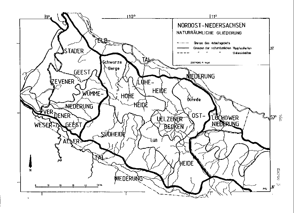
With High Heide the predominantly is moraines existing, the center of large landscape in a northwest-southeast direction passing ridge of the Luneburg Heath designated. The main natural area is located, from northwest to southeast, in the southwest of the Hanseatic City of Hamburg and in the Lower Saxony districts of Harburg , Soltau-Fallingbostel ( Heidekreis ), Lüneburg , Uelzen , Celle and Gifhorn .
The Hohe Heide includes, from northwest to southeast, especially those up to 155 m above sea level. NHN high Harburg Hills , the most Wilseder Mountain 169 m high Wilseder mountain , the most Ahrberg 145 m high Garlstorfer mountains , the Süsing (up to 117 m ) and to the peninsula like encroaching into Uelzener pool Wierener mountains 136 m reach plateau of Lüß . These are terminal moraines from the Warta stage of the Saale Ice Age , which is also known regionally as the Seeve stage . The even slightly higher (up to 123 m ) Schneverdinger terminal moraine of the somewhat older Rehburg Stadium (Drenthe Stadium), which branches off to the south between northeast Schneverdingens and southwest Bispingen , is already counted as part of the Südheide . However, there are divisions that include the higher northern part of the latter with the Hohe Heide.
Natural structure
The main natural spatial unit of the Hohe Heide is divided into two geomorphologically different partial landscapes, namely the Wilseder terminal moraines with moving relief in the northwest and the comparatively flat plateau of the Lüß in the southeast.
The Wilseder terminal moraines mainly follow a ridge line, which runs across the north-facing valleys of the Schmale Aue / lower Seeve and Lopau / lower Luhe rivers to the southeast to the northern edge of the Uelzen basin , where the no longer associated foothills of the Emmendorfer moraines also be broken by the Ilmenau . They disintegrate into three clods through the south-west-north-east running transverse valleys of the upper reaches of Seeve and Luhe.
In the following, systematic list, quasi- witness mountains of the neighboring main units Luheheide (644) and Uelzen and Bevenser Basin (643) as well as the neighboring Zevener Geest (634) to the east are listed in small letters for the sake of clarity:
-
(to 64 Lüneburg Heath )
- 640 Hohe Heide (approx. 1370 km²)
- 640.0 Wilseder terminal moraines (approx. 750 km²), from north-north-west to south-south-east:
-
→ Black mountains , from west to east:
- 634.7 Tostedter Geest (singular up to 101 m )
- 640.00 Black Mountains (approx. 130 km²), from north to south:
- Harburg Mountains ( Black Mountains in the narrower sense ; up to 155 m )
- Lohberge (up to 129 m ; south beyond the B 75 )
- 644.0 Harburg hill country
-
→ Wilseder and Garlstorfer Berge (approx. 330 km²), from west-south-west to east-north-east:
- 641.13 Schneverdinger terminal moraine (up to 123 m )
- 640.01 Wilseder Berge (approx. 180 km² to 169 m )
- 640.02 Garlstorfer Berge (approx. 150 km²; up to 145 m )
- (to 644.2 Toppenstedter Geest ) Höllenberg (up to 93 m )
- 644.5 Wetzer Berge (up to 80 m )
-
→ Raubkammerheide, Lopauer Switzerland and Süsing (approx. 230 km²), from west-south-west to east-north-east:
- 640.03 Raubkammer-Heide (approx. 70 km²)
- 640.04 Lopauer Switzerland (approx. 80 km²)
- 640.05 Süsing terminal moraines (approx. 80 km²; up to 117 m )
- (to 643.1 Emmendorfer Moränen) Emmendorfer Moränen (west wing)
- 640.06 Holthusener Hügelland (approx. 60 km²)
-
→ Black mountains , from west to east:
-
→ Lüß ( 640.1 Sprakensehler terminal moraines ; inc. 641.19 approx. 620 km²)
- 640.10 Lüßmoränen (up to 136 m )
- 640.11 Lüß plateau , south-east roofing of the moraines
- 640.12 Bokeler Sander , smaller sander in the east
- 641.19 Lüß plateau (western roofing ; nominally part of the Südheide, geomorphologically but clearly part of the Lüß; up to 118 m )
- 640.0 Wilseder terminal moraines (approx. 750 km²), from north-north-west to south-south-east:
- 640 Hohe Heide (approx. 1370 km²)
Black mountains

In the form of an isosceles triangle standing on its apex, the Este to the south-west and the Seeve to the south-east, together with its receiving water Elbe as a north boundary, separate an orographic area that is symmetrically divided into two by the ridge of the Black Mountains (640.00) running from north to south . A depression in which, to the east of the ridge line, Buchholz in der Nordheide lies and over which federal road 75 and the railway also run, separates the two forest areas of the Harburg Mountains (up to 155 m ) in the north and the Lohberge (up to 129 m ), which takes up much less area ) in the south. It is noticeable that both partial mountain ranges have their highest peaks clearly in the north.
The east side of the Black Mountains flattens overall gradual from than the west and reached the river level above the level of already to Luheheide calculated Harburg hills (644.0). The latter is settled and can be used agriculturally thanks to a straw blanket , while the Black Mountains themselves are continuously forested in their two main parts. The Tostedter Geest (634.7) on the southern west side, which is largely to the left of the Este and is already part of the Zevener Geest (634) and thus part of the greater Stader Geest (63) region , is much more sparsely equipped and also has more flat waves. Singularly , however, it reaches 101 m in the south on the Otterberg, which juts west into the flat Wümmeniederung (631) . Further north, the Harburg mountains merge a little more abruptly into the landscapes of the Zevener Geest.
The nature reserve Fischbeker Heide (762 ha, northwest slope) and beech forests in the rose garden (285 ha, central west) are located in the Harburg Mountains ; in the Lohbergen there is a 60 hectare area around the highest point, the Brunsberg . Most of the Lohberge are located in the Lüneburg Heath Nature Park .
Elevations northwest of the Seeve
The following elevations of the Black Mountains and their immediate foothills (small letters) are worth mentioning (the height above sea level in brackets and the respective natural area below):
- Hülsenberg ( 154.9 m ) - Harburg Mountains
- Gannaberg ( 150 m ) - Harburg Hills
- Diebeskuhlen (a good 134 m ) - Harburg mountains
- Brunsberg ( 129 m ) - Lohberge
- Langer Stein ( ⊙ ; 129.0 m; near Vahrendorf ) - Harburger Hügelland
- Kiekeberg ( ⊙ ; 127.1 m; near Vahrendorf) - Harburger Hügelland
- Hasselbrack ( 116.2 m ) - Harburg Mountains
- Fistula Mountains ( 107.1 m ) - Harburg Mountains
- Flidderberg (a good 106 m ) - Lohberge
- Otterberg ( 101 m ; "Zeugenberg" west of Otters , southwest of the Lohberge) - Tostedter Geest
- Hill east of Sottorf ( 100.7 m ) - Harburger Hügelland
- Klecker Wald (just under 87 m ; Hünenbett in Klecker Wald ) - Harburger Hügelland
- Sundern ( 82 m ; southeast of Tötensens ) - Harburg hill country
- Reiherberg ( 79.2 m ; northernmost Harburg mountain) - Harburg mountains
- Hitzenberg (a good 54 m ; north-easternmost Harburg hill near Meckelfeld ) - Harburg hill country
Wilseder and Garlstorfer Mountains
Geomorphologically, the mostly wooded high altitude mountainous region southeast of the Seeve , which connects to the upper reaches of the Luhe , is similar to the Black Mountains. It is divided by the valley of the Schmalen Aue , which passes in a north-northwest direction (to the Seeve), into two mountain ranges, the relief of which runs almost mirror-image to each other. The north (north-west) parts near Hanstedt, which are narrower in the transverse direction, run parallel to the dividing river, while the southern parts, each occupying a more rounded area, are located somewhat away from the axis. However, in the Wilseder Mountains (640.01) the highest peaks ( Wilseder Berg : 169 m above sea level ) are in the more compact south (southwest) part, while the north does not exceed 129 m . In contrast, in the Garlstorf Mountains , east of the Schmalen Aue, the north is higher ( Ahrberg : 143 m ), while to the south-east of it in the flattened summit area a maximum of 120 m can be reached.
Between the southern parts of both mountain ranges, following the upper reaches of the Schmalen Aue to the northwest, around the villages of Volkwardingen , Hörpel and Döhle as well as Evendorf to the east, lies a cleared and comparatively fertile basin landscape, which, like the entire valley of the river, to the Garlstorfer Mountains is counted. The up to 117 m high heights south of the basin, breaking the symmetry mentioned, are accordingly also counted as part of the Garlstorfer Mountains.
Overall, the soils of the Garlstorfer Mountains are slightly better than those of the Wilseder. There are also more clearing islands with villages at high altitudes, such as Egestorf . Most of the hilltop villages do not exceed the size of a hamlet , however - Undeloh in the Wilseder and Lübberstedt in the Garlstorf mountains are still among the largest. Only on the east slope of the Garlstorf Mountains, which nominally no longer belongs to the natural area, does the settlement density increase noticeably. If Eyendorf is still in the border area, the larger villages of Salzhausen , the eponymous Garlstorf and Toppenstedt are already in a clear peripheral valley of the Toppenstedter Geest (644.2), which delimits its main mountain Höllenberg ( 93 m ).
The main forest of the Wilseder Mountains flows to the southwest into the Wümmeniederung (main unit 631) and, near Schneverdingen , into that of the Höpenberg ( 120 m ), which introduces the Schneverdingen terminal moraine (641.13, to the southern heath ) , which is somewhat older in geological terms . The BfN's landscape mapping also divides the Höpenberg into the Wilseder Mountains. Purely orographically, the northeast edge of the Schneverdinger terminal moraine with its highest elevation ( 123 m ) as well as the natural area of the Raubkammerheide (640.03) assigned to Bispingen basin belong to the area described here.
The Wilseder Mountains are almost completely located in the 234 km² large nature reserve Lüneburg Heath , which also includes the majority of the Schneverdinger terminal moraine as well as western peripheral lowlands and just over the Schmale Aue at Egestorf. At the Seevetal, the north-western junction to the Harburger Hügelland and the Lohbergen , the only 5 ha small NSG Hangquellmoor is located near Weihe . The landscape lies entirely in the Lüneburg Heath Nature Park .
Elevations between Seeve and Luhe
The following elevations of the Wilseder and Garlstorfer mountains as well as their immediate foothills (small letters) are worth mentioning (in brackets the height above sea level and below the respective natural area):
- Wilseder Berg ( 169.2 m ) - (southern) Wilseder Mountains
- Ahrberg ( 145 m ) - (northern) Garlstorfer Mountains
- Hanstedter Berge ( 129 m ; southwest of Hanstedt ) - (northern) Wilseder Berge
- Hill southwest of Bispingen ( 123 m ) - Schneverdinger terminal moraine
- Höpenberg ( 120 m ; north of Schneverdingen ) - Schneverdinger terminal moraine
- Tütsberg ( 115 m }; west of Behringen ) - Schneverdinger terminal moraine
- Sommerberg ( 120 m ; southeast of Egestorf, beyond the A 7 ) - (eastern) Garlstorfer Berge
- Worthberg ( 117 m ) - (southern) Garlstorfer Mountains
- Höllenberg ( 93 m northwest of Salzhausen ) - Toppenstedter Geest
- Hambornsberg (approx. 91 m ; west of Südergellersen ) - Wetzer Berge
- Rough mountains ( 80 m , north-north-west foothills of the Süsing south-east of Salzhausen ) - Wetzer Berge
Raubkammerheide, Lopauer Switzerland and Süsing
The terminal moraine area to the right (southeast) of the Luhe is, similarly to its northwestern neighboring landscape (see previous section), noticeably symmetrically divided into two. The axis of symmetry forms the Lopau flowing into the Luhe from the south . The differences in relief and soil quality are clearer here. The Raubkammerheide (640.03), which runs from the Lopau to the south-west, is a flat, undulating, barren open space landscape , while the Süsing end moraines , which extend from the Lopau to the south-east, have heavily clayey soils and an overall more varied relief. Of course, on average they do not achieve the relief energy of the north-western parts of the Hohe Heide. The slopes on both sides of the Lopau, which have been assigned their own natural area in Lopau Switzerland (640.04), are particularly steep .
The contiguous forest area of the Süsing, only interrupted by the state road 233 Lüneburg - Ebstorf on the east edge, takes between the road Betzendorf - Barnstedt in the north, the L 234 between ( Rehlingen -) Diersbüttel and ( Wriedel -) Wettenbostel in the west and the valley of the Oechtringer Bach (zur Schwienau ) in the south an area of 36 km². However, the forestation continues seamlessly to the west of the L 234, and further forestation on the same plateau can be found southwest of Betzendorf, on the Timpenberg ( 115 m above sea level ). The highest height ( 117 m ) is reached immediately west of the village, in the cleared area. Overall, the many peaks of the ridge barely tower over each other. Steeper slopes are found mainly on the northeast slope of the main forest and on the eastern slope of the clearing area around ( Hanstedt ) - Velgen . Outside the Hohenheide the comb or better the indicated scanning direction of the Süsings extended, the that of the Garlstorfer mountains extended to the southeast, in which the Uelzener pool locking (643.0) to the north, gradually peak heights decreasing Emmen Strand moraine (643.1), but the almost are completely cleared.
To the west of Diersbüttel, the plateau breaks off abruptly and merges into the steep slopes of Lopau Switzerland, which accompanies the Lopau on its way north from Lopau via Bockum and Rehlingen to Amelinghausen . Especially on its west wing, which also includes the towns of Dehnsen and Ehlbeck , Lopau Switzerland also has comparatively independent elevations that reach up to 100 m .
The Raubkammerheide in the west is uninhabited in its core area and reaches a maximum of 111 m . It only reaches a higher relief energy in the northwest, to the valley of the upper Luhe. In the far west, between the Luhe headwaters coming from the south-west and the Brunau coming from the north-west, the approximately 15 km² large basin landscape around Bispingen and Behringen is part of the Raubkammerheide, as is the narrow valley of the Luhe to the north-east. Just for the pool Bispinger the term "High" Heath seems a bit strange, because the up 123 m here significantly higher Schneverdinger terminal moraine (641.13) of the roll-call Südheide locked this basin and surmounted it by a good 40 meters.
To the southwest of Lopauer Switzerland and Süsing, the landscape gradually flattens out towards the interface with the Lüß. The Holthusener Hügelland (640.06) with Wettenbostel in the extreme north, Wulfsode in the extreme west, Wriedel in the south and Hanstedt in the east basically only has two separate elevations, namely the Westberg ( 104 m ) in the northwest and the Wendberge ( 98 m ) in the Northeast. The L 234 with the eponymous Holthusen I and Wriedel runs between the two hills and their southern roofs. The Wendberge are the only part of the hill country that is forested; their forestation goes north, separated only by the valley of the Oechtringer Bach , flowing over into that of the Süsing. Its Schwienau receiving water roughly marks the border with the Lüß.
The 8 hectare Söhlbruch nature reserve is located in the Raubkammerheide near Bispingen . The nature reserves Wettenbosteler Moor (12 hectares) in the north and Arendorfer Moor (81 hectares) in the south are located in the Holthusener hill country , each on the edge of the valleys. The 310 hectare NSG Barnstedt-Melbecker Bach has only marginal parts of the north of the Süsing . The north-west of the Raubkammerheide, the northern part of Lopauer Switzerland and the extreme north-west of the Süsing terminal moraines are located in the Lüneburg Heath Nature Park .
Elevations between Luhe and Schwienau
The following surveys of the natural areas Raubkammerheide, Lopauer Switzerland, Süsing and Holthusener Hügelland as well as their immediate foothills (small letters) are worth mentioning (the height above sea level in brackets and the respective natural area below):
- Betzendorfer Berg (a good 117 m ; unforested northern Süsing-Randberg west of Betzendorf ) - Süsing terminal moraines
- Glüsinger Berg ( 115.6 m ; north of the Süsing main forest area, southeast of (Betzendorf-) Glüsingen ) - Süsing terminal moraines
- Timpenberg ( 115.2 m ; separate forest area of the Süsing in the northwest) - Süsing terminal moraines (separated from the main forest area to the west)
- Tellmer Berg ( 113.3 m ; west of the Süsing main forest area, southeast of (Betzendorf-) Tellmer ) - Süsing terminal moraines
- Hützeler Berg ( 111 m ; east of Bispingen ) - Raubkammerheide
- Finkenbusch ( 110 m ; Süsing western foothills west of the L 234 and ( Wriedel -) Wettenbostels ) - Süsing terminal moraines
- Eschenberg ( 109 m ; near Hohenbünstorf ) - Emmendorfer Moränen (west wing)
- Hellkuhlenberg ( 108.3 m ; northeast of the Süsing main forest area, near the L 233) - Süsing terminal moraines
- Westberg ( 104 m ; west of the Holthusener hill country, northwest of Holthusen ) - Holthusener hill country
- Fuchsberge ( Dickloh ; 102 m ; west of Lopauer Schweiz, south of Ehlbeck ) - Lopauer Schweiz (west wing)
- Lindenberg ( 102 m ; east of Barums , directly at the breakthrough of the Ilmenau ) - Emmendorfer Moränen (west wing)
- Schierbusch (a good 100 m ; eastern Süsing edge height southeast ( Hanstedt -) Velgens , beyond the L 233) - Süsing end moraine
- Wendberge ( 98 m ; northeast of the Holthusener Hügelland, northwest of Hanstedt ; forest adjoining that of the Süsing to the south) - Holthusener Hügelland
- Vossberg ( 98 m ; northwest of Lopau ) - Lopauer Schweiz (west wing)
- Hill in the Mührgehege ( 83 m ; west-northwest of Oetzens ) - Emmendorfer Moränen (east wing)
- Kronsberg ( 81 m ; northwest Süsing-Randhöhe and Stadtberg Amelinghausen with AT) - Lopauer Switzerland (east wing)
Lüß
The Lüß , also Sprakensehler terminal moraines (640.1), occupies just under the southeastern half of the Hohe Heide in the districts of Uelzen , Gifhorn and Celle . The moraine arc of its core landscape Lüßmoränen (640.10) as the south-eastern main ice boundary of the Warthe Stadium runs, as a comparatively sharp edge of the Uelzen Basin (643.0), initially immediately west of Ebstorf , Stadorf , Groß Süstedts , Gerdaus , Bargfelds , Bahnsens , Suderburgs and Hösseringens southwards. From here, he runs in an arc clockwise around the Blue Mountain ( 128 m above sea level. NHN ) in the sum eastward to Stadensen and Nienwohlde to circle south and once again in an arc clockwise around at just 136 m again slightly higher Wieren mountains around, past Nettelkamp and the eponymous place Wieren , to immediately north of Bad Bodenteich .
The hamlet of Breitenhees - like the last-named places including Suderburgs and Wierens, is now part of the Wrestedt community - is centrally located on the Lüßmoränen; Immediately to the west of the village, in the Dülloh forest, lies the highest point of the Lüß moraines and the Lüß at a good 136 m . About 8.5 km to the west of this is the Lüßberg , which is only slightly lower at 130 m and is the central mountain of the Lüß; the gap between the two peaks is a little over 120 m , which underlines the plateau character.
The western border of the Lüßmoränen is less sharp than the eastern border and is hardly recognizable in the relief. To the west of a line that runs from north to south, just west of the towns of Ellerndorf , Eimke , Wachtenbeck and Unterlüß , the natural change to the Lüß plateau (641.19) is shown primarily by the quality of the soil, which is also recognizable in the understory of today's pine forests. While the sandy-loamy soils of the Lüß moraines are recognizable by the typical accompanying plants of the natural beech and sessile oak forest , the heather areas of the Lüß plateau indicate the significantly more barren and acidic soils of the western roof. The plateau, unlike the moraines, is to a significant extent cut through by waters close to the surface. These are, from north to south, especially the Schmarbeck , Sothrieth and Weesener Bach . To the north of the streams, the plateau is conspicuously cut by the - no longer belonging - Kiehnmoor , which separates a northern part near Brambostel . The Gerdau , which orographically separates the extreme north of the moraine, runs east from the moor area . To the west, the Lüß plateau drops steeply to the Örtze glacial valley ; The 118 m high Haußelberg between the valleys of Sothrieth and Weesener Bach is particularly impressive .
Southwest a line of south Unterluess about Weyhausen , Blickwedel , Lüsche and Repke to ( Dedelstorf -) Oerrel the Lüß gradually changes in the Sander surfaces of Südheide above, the boundary in the vicinity of the Talbildungsgrenze the streams Lutter , Schmalwasser , Lachte and black water to look is. The part to the south-east of a line that goes roughly from Blickwedel to Bokel in the north-east forms a separate natural area as the Lüß plateau (640.11) at the transition from the moraines to the Sandern. Here the soil quality increases noticeably from west to east; around the place Sprakensehl in the north west has only been cleared sparingly, while around Hankensbüttel in the east, favored by loamy soils and floating sand , productive arable land already predominates.
The Bokeler Sander (640.12) cuts directly around Bokel in the east of the Lüß, about 20 m lower than the adjacent landscapes of the Lüß moraines and plateau, but clearly towers above the Schweimker Moor of the Gose-Ise sand plain (641.4) to the south-east. peninsula-like one. To the south of this sander, the eastern border of the Lüß to the sand plain and to the south adjoining southern heath moors (641.3) runs comparatively steep and sharp and without such an intermediate stage.
In the north of the Lüßmoränen lies the Mönchsbruch nature reserve (398 ha), in the northeast the NSG Holdenstedter Teiche (57 ha). The Bornbachtal NSG (a total of 283 hectares) on the north-eastern edge, between Blauem Berg and Wierener Mountains, encroaches on the natural area only to a minimal extent . On the western edge of the Bokeler Sander lies the NSG Bullenkuhle , which is only 2 hectares in size, and the NSG Bokeler Heide (19 ha) at the southern junction of the Sander to the Lüß plateau . The NSG Schnuckenheide (20 ha) is located on the eastern southern edge of the plateau , further to the north-west the nature reserves Obere Lachte, Kainbach, Jafelbach and Lutter (a total of 1090 and 2435 ha) only minimally extend into the plateau. The two-part NSG heather areas of the middle Lüß plateau (293 hectares) and most of the NSG Weesener Bach (348 hectares in total) are located on the Lüß plateau .
Elevations of the Lüß
The following elevations of the Lüß are worth mentioning (in brackets the height above sea level and below the respective natural area):
- Hill in Dülloh (a good 136 m ; immediately west of the hamlet of Breitenhees ; central mountain of the Lüßmoränen) - Lüßmoränen
- Wierener Berge (almost 136 m ; Lüß-Randberg, which protrudes like a peninsula into the Uelzen basin, southwest of Wierens ; the highest peak is called Hoher Berg ) - Lüßmoränen
- Lüßberg ( 130 m ; central mountain of Lüß east of Unterlüß ) - Lüßmoränen
- Blauer Berg ( 128 m ; Lüß-Randberg, which protrudes like a peninsula into the Uelzen basin, southeast of Suderburg ) - Lüßmoränen
- Haußelberg ( 118 m ; western Lüß-Randberg, north of the Weesener Bach and south of the Sothrieth ) - Lüßplateau
- Eicksberg ( 107 m ; western Lüß-Randberg, south of the Weesener Bach) - Lüßplateau
- Thonhopsberg ( 104 m ; northwestern Lüß-Randberg northwest of Ellerndorf ) - Lüßmoränen
- Bokelsberg ( 103 m ; most southeast Lüß-Randberg, immediately northwest of the Oerreler Moor ) - Lüß plateau
- Faßberg ( 93 m ; western Lüß-Randberg, north of Sothrieth and Landwehrbach, northeast of Faßberg ) - Lüßplateau
- Wittenberg ( 93 m ; east Lüß-Randberg east of Bokels ) - Bokeler Sander
-
Bosenberg ( 93 m ; Lüß-Randberg northeast of the railway, immediately west of Ebstorf ) - Lüßmoränen
- Bullenberg ( 78 m , south-southwest foothills)
- Lerchenberg ( 92 m ; east Lüß-Randberg to the Uelzen basin northeast of Dreilingen ) - Lüßmoränen
More global mountains
The following elevations of the Hohe Heide are the highest mountain of an orographic partial mountain range or at least particularly dominant or (at least on one side) prominent (in brackets the height above sea level and subsequently the respective natural area):
- Wilseder Berg ( 169.2 m ) - Wilseder Mountains
- Hülsenberg ( 154.9 m ) - Harburg Mountains
- Ahrberg ( 145 m ) - Garlstorfer Mountains
- Hill in Dülloh (a good 136 m ; central mountain of the Lüßmoränen) - Lüßmoränen
- Wieren Mountains (almost 136 m ; Lüß-Randberg, which protrudes like a peninsula into the Uelzen basin, southwest of Wieren ) - Lüßmoränen
- Brunsberg ( 129 m ) - Lohberge
- Blauer Berg ( 128 m ; Lüß-Randberg, which protrudes like a peninsula into the Uelzen basin, southeast of Suderburg ) - Lüßmoränen
- Haußelberg ( 118 m ; western Lüß-Randberg, north of the Weesener Bach and south of the Sothrieth ) - Lüßplateau
- Betzendorfer Berg (a good 117 m ; northern Süsing-Randberg west of Betzendorf ) - Süsing terminal moraines
- Bokelsberg ( 103 m ; most southeast Lüß-Randberg, immediately northwest of the Oerreler Moor ) - Lüß plateau (is not the highest elevation in the natural area!)
Individual evidence
- ↑ a b c d e f Sofie Meisel: Geographical land survey: The natural spatial units on sheet 57 Hamburg-Süd. Federal Institute for Regional Studies, Bad Godesberg 1964. → Online map (PDF; 4.4 MB)
- ↑ Sketch of a map according to the Westermann Lexicon of Geography from 1983 (ill. P. 541) in a master's thesis by Martin Nagel
- ^ Emil Meynen , Josef Schmithüsen et al .: Handbook of the natural spatial structure of Germany . Federal Institute for Regional Studies, Remagen / Bad Godesberg 1953–1962 (9 deliveries in 8 books, updated map 1: 1,000,000 with main units 1960).
- ↑ a b c Wolfgang Meibeyer : Geographical land survey: The natural spatial units on sheet 58 Lüneburg. Federal Institute for Regional Studies, Bad Godesberg 1980. → Online map (PDF; 4.8 MB)
- ^ A b Sofie Meisel: Geographical Land Survey: The natural spatial units on sheet 73 Celle. Federal Institute for Regional Studies, Bad Godesberg 1959. → Online map (PDF; 3.9 MB)
- ↑ a b Wolfgang Meibeyer : Geographical Land Survey: The natural spatial units on sheet 74 Salzwedel. Federal Institute for Regional Studies, Bad Godesberg 1970. → Online map (PDF; 4.7 MB)
- ↑ Corrected BfN values and measured values; see footnotes to the partial values!
- ↑ a b c d e BfN landscape profiles for 640: Black Mountains ( Memento of the original from July 21, 2011 in the Internet Archive ) Info: The archive link was inserted automatically and has not yet been checked. Please check the original and archive link according to the instructions and then remove this notice. (640.00), Wilseder Berge ("Wilseder Berg") ( Memento of the original from July 21, 2011 in the Internet Archive ) Info: The archive link was inserted automatically and has not yet been checked. Please check the original and archive link according to the instructions and then remove this notice. (640.01), Sprakensehler Endmoränen ("Lüß") ( Page no longer available , search in web archives ) Info: The link was automatically marked as defective. Please check the link according to the instructions and then remove this notice. (640.1), Hochheide without anything else listed ("Hohe Heide") ( page no longer available , search in web archives ) Info: The link was automatically marked as defective. Please check the link according to the instructions and then remove this notice. (640.02-640.06)
- ↑ The BfN specification 158 km² refers to a delimitation inc. the south-west roof up to shortly before the Otterberg
- ↑ The BfN specification 227 km² refers to a delimitation inc. the Osterheide and the Höpenberg near Schneverdingen , part of the Schneverdinger terminal moraine.
- ↑ a b c d e f g Polygon measurement according to the course on the individual sheets
- ↑ 482 km² without 641.19 according to BfN.
- ↑ a b c d e Map services of the Federal Agency for Nature Conservation ( information )
- ↑ Der Hülsenberg ( Memento of the original from February 21, 2017 in the Internet Archive ) Info: The archive link was automatically inserted and not yet checked. Please check the original and archive link according to the instructions and then remove this notice. azf DTK 25 (without explicit name designation)
- ↑ Die Diebeskuhlen ( Memento of the original dated February 21, 2017 in the Internet Archive ) Info: The archive link was inserted automatically and has not yet been checked. Please check the original and archive link according to the instructions and then remove this notice. on AK 2.5
- ↑ Langer Stein and Kiekeberg ( Memento of the original from February 21, 2017 in the Internet Archive ) Info: The archive link was automatically inserted and not yet checked. Please check the original and archive link according to the instructions and then remove this notice. on DTK 25
- ↑ Die Fistelberge ( Memento of the original from February 21, 2017 in the Internet Archive ) Info: The archive link was automatically inserted and not yet checked. Please check the original and archive link according to the instructions and then remove this notice. on DTK 25
- ↑ Der Flidderberg ( Memento of the original dated February 21, 2017 in the Internet Archive ) Info: The archive link was inserted automatically and has not yet been checked. Please check the original and archive link according to the instructions and then remove this notice. on DTK 50
- ↑ Der Otterberg ( Memento of the original from February 21, 2017 in the Internet Archive ) Info: The archive link was automatically inserted and not yet checked. Please check the original and archive link according to the instructions and then remove this notice. on DTK 50
- ↑ Sottorf and hill ( memento of the original from February 21, 2017 in the Internet Archive ) Info: The archive link was automatically inserted and not yet checked. Please check the original and archive link according to the instructions and then remove this notice. at the DTK 25
- ↑ The Hünenbettgebiet in Klecker Wald ( memento of the original from February 21, 2017 in the Internet Archive ) Info: The archive link was automatically inserted and not yet checked. Please check the original and archive link according to the instructions and then remove this notice. on AK 2.5
- ↑ Der Sundern ( Memento of the original from February 21, 2017 in the Internet Archive ) Info: The archive link was inserted automatically and has not yet been checked. Please check the original and archive link according to the instructions and then remove this notice. on AK 2.5
- ↑ The Reiherberg ( Memento of the original from February 21, 2017 in the Internet Archive ) Info: The archive link was automatically inserted and not yet checked. Please check the original and archive link according to the instructions and then remove this notice. on DTK 25
- ↑ Der Hitzenberg ( Memento of the original from February 21, 2017 in the Internet Archive ) Info: The archive link was automatically inserted and not yet checked. Please check the original and archive link according to the instructions and then remove this notice. on AK 2.5
- ^ Lower Saxony environmental maps. ( Topographic Map ) Retrieved March 26, 2018 .
- ^ Lower Saxony environmental maps. ( DGK 5 historical ) Retrieved March 26, 2018 .
- ^ Lower Saxony environmental maps. ( Topographic Map ) Retrieved March 26, 2018 .
- ^ Lower Saxony environmental maps. ( Topographic Map ) Retrieved March 26, 2018 .
- ^ Lower Saxony environmental maps. ( Topographic Map ) Retrieved March 26, 2018 .
- ^ Lower Saxony environmental maps. (TK50 historical) Retrieved March 26, 2018 .
- ^ Lower Saxony environmental maps. ( DGK 5 historical ) Retrieved March 26, 2018 .
- ^ Lower Saxony environmental maps. ( DGK 5 historical ) Retrieved March 26, 2018 .
- ^ Lower Saxony environmental maps. (TK50 historical) Retrieved March 26, 2018 .
- ↑ On the Hamburg (South) sheet, even Diersbüttel is already completely included in Lopau Switzerland. However, the place is on the comparatively normal western slope of the ridge, while the steep slopes only begin about 1 km to the west.
- ↑ Der Betzendorfer Berg ( Memento of the original from February 21, 2017 in the Internet Archive ) Info: The archive link was automatically inserted and not yet checked. Please check the original and archive link according to the instructions and then remove this notice. on the AK 5
- ↑ On the map for sheet Hamburg (South) the mountain has already been counted as part of Lopau Switzerland; however, their moving relief only begins much further west. It should be noted that on the realm map, which served as the basis, this forest was still separated from that of the actual Süsing.
- ↑ Der Westberg ( Memento of the original from March 5, 2016 in the Internet Archive ) Info: The archive link was inserted automatically and has not yet been checked. Please check the original and archive link according to the instructions and then remove this notice. on the DTK 50
- ↑ Fuchsberge / Dickloh ( Memento of the original from March 4, 2016 in the Internet Archive ) Info: The archive link was inserted automatically and has not yet been checked. Please check the original and archive link according to the instructions and then remove this notice. on AK 5
- ↑ Der Lindenberg ( Memento of the original from April 24, 2014 in the Internet Archive ) Info: The archive link was inserted automatically and has not yet been checked. Please check the original and archive link according to the instructions and then remove this notice. on the AK 2.5
- ↑ Der Schierbusch ( Memento of the original from April 24, 2014 in the Internet Archive ) Info: The archive link was inserted automatically and has not yet been checked. Please check the original and archive link according to the instructions and then remove this notice. on the AK 5
- ↑ Die Wendberge ( Memento of the original from April 24, 2014 in the Internet Archive ) Info: The archive link was automatically inserted and not yet checked. Please check the original and archive link according to the instructions and then remove this notice. on the DTK 50 (DZK 25 shows the name)
- ↑ The Mührgehege ( Memento of the original from April 24, 2014 in the Internet Archive ) Info: The archive link was inserted automatically and has not yet been checked. Please check the original and archive link according to the instructions and then remove this notice. on the DTK 25 - DTK 50 explicitly states the height.
- ↑ Der Dülloh ( Memento of the original from March 5, 2016 in the Internet Archive ) Info: The archive link was inserted automatically and has not yet been checked. Please check the original and archive link according to the instructions and then remove this notice. on the DTK 25 - the 136 m are clearly exceeded, unlike the Wieren mountains.
- ↑ a b Wierener Berge and Blauer Berg ( Memento of the original from February 21, 2017 in the Internet Archive ) Info: The archive link has been inserted automatically and has not yet been checked. Please check the original and archive link according to the instructions and then remove this notice. on TK 100
- ↑ Der Eicksberg ( Memento of the original from March 6, 2016 in the Internet Archive ) Info: The archive link was inserted automatically and has not yet been checked. Please check the original and archive link according to the instructions and then remove this notice. on the AK 2.5
- ↑ The Bosenberg and its foothills ( memento of the original from February 21, 2017 in the Internet Archive ) Info: The archive link was automatically inserted and not yet checked. Please check the original and archive link according to the instructions and then remove this notice. on TK 100
- ↑ Der Lerchenberg ( Memento of the original from February 21, 2017 in the Internet Archive ) Info: The archive link has been inserted automatically and has not yet been checked. Please check the original and archive link according to the instructions and then remove this notice. on TK 100