
Harburg Mountains
| Harburg Mountains | |
|---|---|
| Highest peak | Hülsenberg ( 155 m above sea level ) |
| location | Harburg and Hamburg districts; Lower Saxony / Hamburg ( Germany ) |
| part of | Black Mountains ( Lüneburg Heath ) |
| Coordinates | 53 ° 25 ' N , 9 ° 52' E |
| Type | Terminal moraine |
 |
|


.jpg)
The Harburg mountains are a maximum of about 155 m above sea level. NHN high ridge in the Harburg district in Lower Saxony , whose foothills extend to the south of Hamburg . They form the northern part of the Black Mountains , the southern part of which is the Lohberge . Often (The) Black Mountains only refer to the northern part of the Harburg Mountains on maps , but the Black Mountains natural area is much larger. Geomorphologically , they are a terminal moraine formed in the Saale Ice Age . The wooded area is a popular local recreation area and is promoted within the Rosengarten Regional Park as an ILE region with an Integrated Rural Development Concept (ILEK).
geography
location
The Harburg Mountains extend in the north-northwest of the Hohe Heide , the central terminal moraine of the Lüneburg Heath , and south of the Altes Land , part of the Elbmarschen . A little south of the center of the hilly landscape on the southwestern edge of the Lower Saxon unitary community of Rosengarten is the Buchholz triangle of the federal motorways 1 and 261 .
The northern edge of the Harburg Mountains border the Hamburg districts of Neugraben-Fischbek and Hausbruch , the districts of Heimfeld and Eißendorf lie to the north- northeast and Marmstorf to the northeast of the landscape. The rest of the area is in the Harburg district in Lower Saxony . On the eastern edge of the landscape are the villages of Vahrendorf , Sottorf , Sieversen and Dibbersen . The south-south-east edge and transition area to the adjoining Lohbergen to the south is formed by the federal road 75 , which runs roughly in a north-east-south-west direction through a depression , which leads from Dibbersen through Steinbeck ( belonging to Buchholz in the Nordheide ) and past the district of Meilsen to Trelde . Drestedt lies on the south-south-west edge and to the north of it on the west edge Wenzendorf with the districts Wennerstorf , Rade , Ohlenbüttel , Eversen-Heide and Schwiederstorf . Daerstorf and Wulmstorf are on the north-west edge and Neu Wulmstorf in the north-north-west . The Harburg Mountains are passed by the Seeve rivers in the east and Este in the west, which both run somewhat further away from the ridge and both flow in northerly directions into the Elbe .
Natural allocation
The Harburg mountains are in the natural environment feature unit group Luneburg Heath (no. 64) in the main unit High Heide (640) and in the sub unit Wilseder end moraine (640.0) for natural space Schwarze Berge (640.00). To the north of the Harburg mountains lies the natural area Das Alte Land (670.02), which belongs to the main unit Harburger Elbmarschen (670), and to the east the natural area Harburger Hügelland (644.0), which belongs to the main unit Luheheide (644). South of the Harburg Mountains are the Lohberge as the southern part of the Black Mountains . To the southwest the landscape leads to the sub-unit Tosteder Geest (634.7) and to the west to the Apenser Lehmgeest (634.6), both of which belong to the main unit Zevener Geest (634).
Surveys
The Harburg Mountains include - sorted by height in meters (m) above sea level (MSL; unless otherwise specified according to):
- Gannaberg ( ⊙ ; approx. 155 m), near Langenrehm
- Hülsenberg ( ⊙ ; approx. 155 m), near Sieversen
- Diebeskuhlen ( ⊙ ; approx. 135 m), near the Sottorfer Vahrendorf settlement
- Langer Stein ( ⊙ ; 129.0 m; naturally already Harburg hill country ), near Vahrendorf
- Kiekeberg ( ⊙ ; 127.1 m; naturally already Harburg hill country ), near Vahrendorf
- Hasselbrack ( ⊙ ; 116.2 m), highest point in Hamburg , near Neugraben-Fischbek (border with Lower Saxony)
- Fistula mountains ( ⊙ ; 107.1 m), near Alvesen
- Tempelberg ( ⊙ ; 95.3 m), near Daerstorf
Protected areas
The nature reserve Fischbeker Heide ( CDDA no. 4384; designated 1958; 7.62 km² ) in the north (Black Mountains) and beech forests in the rose garden (CDDA no. 318259; 2003; 2.85 km²) are in the Harburg Mountains Middle part. They are designated as fauna-flora-habitat areas Fischbeker Heide (CDDA no. 2525-301) and beech forests in the rose garden (CDDA no. 2525-302). The nature reserve Rosengarten – Kiekeberg – Stuvenwald (CDDA no. 323951; 1965; 58.68 km²) is located in large parts of the landscape .
Landscape image
The Harburg Mountains form a hilly forest , heather and arable landscape. The north of the ridge, often referred to as (The) Black Mountains on maps , is quite rugged by north German standards. The Black Mountains Wildlife Park is located there . Karlstein, a boulder from the Ice Age, is located in the Rosengarten state forest . At the eastern edge near Sieversen, there are now only eight of the ten previously protected hiking blocks (see: List of natural monuments in the Harburg district ). However, the classification as a natural monument belies the actual function of the rocks as landmarks of time, which is why the stones 1991 cultural monuments ( construction and art monuments : small monuments ) rededicated were and so the historical dimension of the objects was emphasized (see also below: section 4.2 ). This reallocation did not go smoothly in so far as a change in the ordinance on natural monuments in the Harburg district is still pending and the stones are still listed as natural monuments by the district.

Cultural history
archeology
In the area of the Harburg Mountains there are a number of tombs that indicate a first settlement by the Neolithic beaker culture and in the Bronze Age . These include a stone box in the Rade field , the large stone graves in Daerstorf and Elstorf as well as other archaeological sites in the area, such as the archaeological hiking trail in the Fischbeker Heide . Furthermore, the Spitzwecken from Ovelgönne testify to the activity during the Pre-Roman Iron Age (Celtic Iron Age) and other finds near Daerstorf from a settlement around 770.
Historic forest borders
Today's rose garden was marked with boundary stones from the 15th century. The originally more than 235 stones are largely preserved today and describe, among other things, forest boundaries from the 15th century (20 stones) and the 1750s (eastern state forest boundary made of 65 stones, western state forest boundary made of 87 stones).
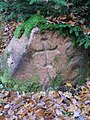
Grenzstein (No. S-07) near Sottorf, Rosengarten (15th century)
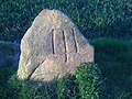
Grenzstein (No. S-20) near Leversen, Rosengarten (15th century)
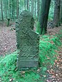
Sieverser Stein (No. 1 of 65), forest border from 1750

Moisburger Stein (No. 65 of 65), forest border from 1750

Grenzstein (18th century), Rosengarten (No. 1 of 87)


Traffic and walking
Streets
The Harburg mountains are crossed by the federal motorways 1 and 261 ; The ridge can be easily reached from their junctions in Neu Wulmstorf-Rade , Buchholz-Dibbersen (both A1 ) and Rosengarten-Tötensen (A 261). The A 7 , from whose junction Marmstorf the hilly landscape can be approached , runs through the area in the northeast.
train
The Buchholz station in the Nordheide (on the Wanne-Eickel – Hamburg and Heidebahn ), the Klecken stop (Wanne-Eickel – Hamburg) and the Neugraben or Fischbek S-Bahn stations can be used by rail . From there, regular buses run with numerous stops that bring you closer to the Harburg mountains or even into them.
Hiking and biking trails
The hiking trails in the Harburg Mountains include:
- European long-distance hiking trail E1 , from Neugraben-Fischbek in a north-south direction through the Harburg Mountains to Buchholz in the Nordheide and then on through the Lohberge
- Heidschnuckenweg (long-distance hiking trail), from Hamburg-Neugraben-Fischbek train station through the Lüneburg Heath to Celle Castle
- Hiking trail W1 Harburger Berge, in the north of the Harburger Berge - (The) Black Mountains
- Hiking trail W2 Wildlife Park, there and around the Black Mountains Wildlife Park
- Hiking trail W3 Buchholz, on the southeastern edge and outside the Harburg mountains
- Hiking trail W4 Wulmstorfer Heide, in the north and north-northwest of the Harburg mountains
- Hiking trail W5 Black Mountains, in the northern central part of the Harburg Mountains
- Hiking trail W6 Fischbeker Heide, in the north of the Harburg Mountains - (The) Black Mountains
- Hiking trail W9 Appelbeck-Karlstein, in the southern central part and west of the Harburg mountains
- Hiking trail W10 Buchholz-Appel, in the southern part and west of the Harburg mountains
- Hiking trail W11 Buchholz-Drestedt, in the southern part and southwest of the Harburg mountains
The long- distance cycle route Hamburg – Bremen leads from Sottorf along the Rosengartenstraße to Bachheide .
Individual evidence
- ↑ a b Topo map with Die Diebeskuhlen ( Memento of the original from May 2, 2014 in the Internet Archive ) Info: The archive link was inserted automatically and has not yet been checked. Please check the original and archive link according to the instructions and then remove this notice. (DTK25; see large enlargement of the map), on natur-erleben.niedersachsen.de
- ↑ Black Mountains landscape profile ( Memento of the original from July 21, 2011 in the Internet Archive ) Info: The archive link was inserted automatically and has not yet been checked. Please check the original and archive link according to the instructions and then remove this notice. (64003), at the Federal Agency for Nature Conservation , on bfn.de
- ^ Sofie Meisel: Geographical land survey: The natural spatial units on sheet 57 Hamburg-Süd. Federal Institute for Regional Studies, Bad Godesberg 1964. → Online map (PDF; 4.4 MB)
- ↑ a b Map services of the Federal Agency for Nature Conservation ( information )
- ↑ Hasselbrack-Höhe u. a. according to the inscription on the summit cross that was available until 2013
- ^ Werner Voss: Old boundary stones and heaps of earth. Information about the history of Verdisch-Bremen monasteries, monasteries, villages and forests in the Rosengarten area. Reprint from the Stader yearbook 1995 and 1996. Self-published, Rosengarten, Brahmhof 5 1999, p. 96 .
- ↑ 1200 year old burial ground from the Saxon period discovered near Elstorf ( memento from August 28, 2013 in the web archive archive.today ), from August 28, 2013, accessed on August 28, 2013, at han-online.de
- ↑ Horse grave - grave gift or animal sacrifice ( memento from August 28, 2013 in the web archive archive.today ), from August 28, 2013, accessed on August 28, 2013, on han-online.de
- ↑ New finds from archaeological excavations in Neu Wulmstorf-Elstorf , in archaeological excavations in Neu Wulmstorf-Elstorf , from November 4, 2011, on dein-hollenstedt.de
- ↑ Elstorf Grab 475. (No longer available online.) In: blog.amh.de. Archived from the original on August 4, 2015 ; Retrieved September 4, 2015 . Info: The archive link was inserted automatically and has not yet been checked. Please check the original and archive link according to the instructions and then remove this notice.
- ↑ Forest borders and boundary stones in the Rosengarten forest , private documentation
- ↑ Hiking trail W1 Harburg Mountains. (No longer available online.) Archived from the original on June 22, 2013 ; Retrieved September 29, 2013 . Info: The archive link was inserted automatically and has not yet been checked. Please check the original and archive link according to the instructions and then remove this notice.
- ↑ Hiking trail W2 Wildlife Park. (No longer available online.) Archived from the original on June 23, 2013 ; Retrieved September 29, 2013 . Info: The archive link was inserted automatically and has not yet been checked. Please check the original and archive link according to the instructions and then remove this notice.
- ↑ Hiking trail W3 Buchholz. (No longer available online.) Archived from the original on December 7, 2013 ; Retrieved September 29, 2013 . Info: The archive link was inserted automatically and has not yet been checked. Please check the original and archive link according to the instructions and then remove this notice.
- ↑ Hiking trail W4 Wulmstorfer Heide. (No longer available online.) Archived from the original on July 18, 2013 ; Retrieved September 29, 2013 . Info: The archive link was inserted automatically and has not yet been checked. Please check the original and archive link according to the instructions and then remove this notice.
- ↑ Hiking trail W5 Black Mountains. (No longer available online.) Archived from the original on March 24, 2014 ; Retrieved September 29, 2013 . Info: The archive link was inserted automatically and has not yet been checked. Please check the original and archive link according to the instructions and then remove this notice.
- ↑ Hiking trail W6 Fischbeker Heide. (No longer available online.) Archived from the original on March 24, 2014 ; Retrieved September 29, 2013 . Info: The archive link was inserted automatically and has not yet been checked. Please check the original and archive link according to the instructions and then remove this notice.
- ↑ Hiking trail W9 Appelbeck-Karlstein. (No longer available online.) Archived from the original on March 24, 2014 ; Retrieved September 29, 2013 . Info: The archive link was inserted automatically and has not yet been checked. Please check the original and archive link according to the instructions and then remove this notice.
- ↑ Hiking trail W10 Buchholz-Appel. (No longer available online.) Archived from the original on March 24, 2014 ; Retrieved September 29, 2013 . Info: The archive link was inserted automatically and has not yet been checked. Please check the original and archive link according to the instructions and then remove this notice.
- ↑ Hiking trail W11 Buchholz-Drestedt. (No longer available online.) Archived from the original on March 24, 2014 ; Retrieved September 29, 2013 . Info: The archive link was inserted automatically and has not yet been checked. Please check the original and archive link according to the instructions and then remove this notice.