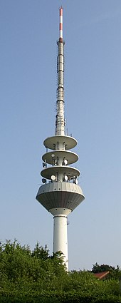
Gannaberg
| Gannaberg | ||
|---|---|---|
| height | 155 m above sea level NHN | |
| location | at Langenrehm ; District of Harburg , Lower Saxony ( Germany ) | |
| Mountains | Harburg Mountains | |
| Coordinates | 53 ° 23 '51 " N , 9 ° 52' 1" E | |
|
|
||
| Age of the rock | quaternary | |
| particularities | - Rosengarten telecommunications tower - Langenrehm prince monument |
|
|
Map of the Harburg mountains with the Gannaberg |
||
The Gannaberg is about 155 m above sea level. NHN next to the Hülsenberg (approx. 155 m ) the highest elevation of the Harburg mountains and the district of Harburg in Lower Saxony . It is located in the municipality of Rosengarten near Langenrehm . The Rosengarten telecommunications tower stands on top of it, and the Langenrehm prince monument is nearby .
geography
location
The Gannaberg rises between Sieversen in the northeast and the Emsener district Langenrehm in the southwest and belongs to the district Langenrehm; they are all in the municipality of Rosengarten. District road 26 leads over its northern flank as a connection between the two villages .
geology
The Gannaberg is part of an elongated compression moraine that was left by the Fuhlsbüttler advance in the Quaternary and extends from the Kiekeberg ( 127.1 m ) near Vahrendorf in the north-northeast to the Nuppenberg (approx. 115 m ) near Dibbersen in the south-southwest.
Natural allocation
The Gannaberg belongs to the natural spatial main unit group Lüneburg Heath (No. 64), in the main unit Hohe Heide (640) and in the sub-unit Wilseder terminal moraines (640.0) to the natural area Black Mountains (640.00). To the east the landscape slopes gently into the sub-unit Harburger Hügelland (644.0), which is part of the main unit Luheheide (644).
Mountain height and hilltops
The Gannaberg is about 155 m high as part of its south-south-west summit ( ⊙ ) ; its north-northeast tip ( ⊙ ) reaches a height of 150 m . The peaks of both peaks are about 370 m apart.
Protected areas
Parts of the protected landscape area Rosengarten – Kiekeberg – Stuvenwald ( CDDA no. 323951; designated 1965; 58.68 km² ) spread out on the Gannaberg . A little to the west of the elevation is the beech forests in the rose garden nature reserve (CDDA no. 318259; 2003; 2.85 km²).
Telecommunication tower Rosengarten
About 120 m southwest of the Gannaberg summit, above the 149 m height line, stands the Rosengarten telecommunications tower , a 161 m high reinforced concrete tower belonging to the German radio tower . It has replaced an old steel frame tower and a smaller type tower since the mid-1990s. The tower has many radio relay and cellular systems. It is broadcast by VHF radio and DVB-T television.
Prince Monument Langenrehm

To the west of the transition area from Gannaberg to the adjacent Hülsenberg to the north , on the Vogelhüttenberg hill (approx. 130 m ) between district roads 26 and 52 stands the prince monument Langenrehm ( 53 ° 24 '7.4 " N , 9 ° 51" 49.1 " E ). It was built in 1911 as a small tetrahedron made of granite stones and rededicated in 1953. Its inscription commemorates George V (1819–1878), the last king of the Kingdom of Hanover, Ernst August von Hannover (1845–1923), the last Crown Prince of this kingdom, Duke of Cumberland (1866–1923) and Duke of Braunschweig and Lüneburg, and to Ernst August von Braunschweig (1887–1953), Duke of Braunschweig and Lüneburg.
literature
- Inga Treptow: The Harburg Mountains - An example of the glacial series in the north German glaciation area , Bachelor thesis, University of Vechta, 2007, 53 p., On diplomarbeiten24.de, ISBN 978-3-640-11476-4
Individual evidence
- ↑ a b c d topographical map with the Gannaberg ( memento of the original from February 13, 2015 in the Internet Archive ) Info: The archive link has been inserted automatically and has not yet been checked. Please check the original and archive link according to the instructions and then remove this notice. (DTK 25; for mountain / crest heights see large enlargement of the map), on natur-erleben.niedersachsen.de
- ↑ Inga Treptow: see The Harburg Mountains ... in the literature section
- ^ Sofie Meisel: Geographical land survey: The natural spatial units on sheet 57 Hamburg-Süd. Federal Institute for Regional Studies, Bad Godesberg 1964. → Online map (PDF; 4.4 MB)
- ↑ a b Map services of the Federal Agency for Nature Conservation ( information )


