Long fame
|
Long fame
Municipality Rosengarten
Coordinates: 53 ° 23 ′ 51 ″ N , 9 ° 51 ′ 36 ″ E
|
|
|---|---|
| Height : | 139 m |
| Postal code : | 21224 |
| Area code : | 04108 |
Langenrehm is a part of the municipality of Emsen and is located in the district of Harburg in Lower Saxony in the municipality of Rosengarten . It is "the highest village in the north German lowlands " and has about 300 inhabitants.
Geographical location
Langenrehm is located in the southern foothills of the Harburg mountains . Gannaberg , located east of the town center, is about 155 m high, next to the equally high Hülsenberg , which is located a little further north of it, and is the highest elevation of this landscape , which is part of the Black Mountains natural area .
The village is idyllically situated in hilly forest and meadowland, which, with the exception of the village, is designated in the regional spatial planning program of the Harburg district as a landscape protection area Rosengarten – Kiekeberg – Stuvenwald ( CDDA No. 323951; 1965 designated; 58.68 km² ). Due to the hilly landscape, which is particularly overgrown by beech forests, the area around the former Rosengarten Forestry Office, west of the village, belongs to the European Union as a FFH area beech forests in Rosengarten (FFH no ) reported.
Spatially, Langenrehm is divided into two residential complexes by a specially protected biotope (§28a / b NNatG): the northwestern, older part is called Langenrehm Dorf and the southeastern, younger part is called Langenrehm Siedlung ; the latter part is partly in a water protection area .
The most important traffic connection is the district road 26 (Langenrehmer Dorfstraße) , which connects Langenrehm with the villages of Sieversen in the north and Emsen in the south. The bus stops Langenrehm, Kabenweg (village) and Langenrehm, Am Hamboken (settlement), which are in the “Greater Hamburg area” of the HVV, are located here.
history
In old maps, the place name is often still given as a long cream. The first part of the name comes from the "Long Mountain" on the ridge of which the village is located. The second part comes from the term "Rähm" and, like many other vernacular spellings, is in high German. The frame is the upper horizontal end of the half-timbered wall or the wooden frame construction.
Culture and sights
Langenrehm is a suburban town that looks like a rural village. It is located in the Hamburg metropolitan region and is dependent on the surrounding supply options due to the lack of shopping opportunities.
Nearby supply centers:
The supermarket in Vahrendorf , a few kilometers away, is another shopping option, but is not declared as a sub-center in the regional spatial planning program and is therefore listed separately here.
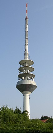
North of the settlement is the highest elevated tank of the Harburg water procurement office. A striking feature is the Rosengarten telecommunications tower on the Gannaberg, operated by Deutsche Funkturm , the tallest building in the Rosengarten community and visible from the Hamburg Köhlbrand Bridge .
Another area is the north-northwest of the circuit road 26 towards Sieversen preferred Prince Langenrehm monument , a 1911 erected from 120 Fuhren granite tetrahedron . Its inscription is reminiscent of Hanoverian kings and dukes: Georg V , King of Hanover, Ernst August , Duke of Cumberland and Duke of Braunschweig and Lüneburg, and Ernst August , Duke of Braunschweig and Lüneburg.
In the museum cartwright in Langenrehm , museum visitors learn about traditional cartwright craft. The building ensemble, consisting of a workshop, house and sawmill, belonged to the Peters cartwright. The workshop is as it was in 1930, and all machines are still fully functional. The exhibition in the house shows family life on the Stellmacherhof around 1930. The wheelwright demonstrates his craft on opening days.
Between the Langenrehm village and the Langenrehm settlement there is a barrow that was destroyed by rock breakers in the 19th century.
The hilly landscape of the local area is particularly attractive for hikers, Nordic walkers, joggers and cyclists; Cross-country skiers also find opportunities.
Furthermore, the place is popular with cyclists due to the steep gradient between Langenrehm and Sieversen as well as the weaker but longer gradient in a southerly direction to Dibbersen . The route of the Vattenfall Cyclassics therefore often leads through Langenrehm.
The environment is also suitable for riders; Horses can be accommodated in riding stables and stables in the village.
Broadband internet has only been available in Langenrehm since 2006. Although the local telephone network is connected to the relatively distant Deutsche Telekom exchange in Tötensen , data transfer rates of up to 6Mbit / s could initially be provided by installing DSLAMs in the local distributor and connecting them via HYTAS Outdoor . An upgrade of the DSLAMs to ADSL2 + in 2008 enabled transmission rates of up to 16Mbit / s in the entire village. After another upgrade of the DSLAMs in 2014, transmission rates of up to 25Mbit / s are provided via the telephone network via VDSL2 .
In 2006, the cable television network was also expanded with back-channel technology by the operator Kabel Deutschland . In the meantime, Internet connections with transfer rates of up to 100Mbit / s are offered in Langenrehm by the latter.
politics
In the municipality of Emsen / Langenrehm, a local mayor and eight other local council members are elected. The current local mayor is Hans-Hermann Böttcher ( SPD ).
Partial composition of the local council:
Web links
References and comments
- ↑ Information from the Buchholz city map


