
Heidschnuckenweg
Coordinates: 53 ° 28 ′ 29.3 ″ N , 9 ° 49 ′ 9.5 ″ E
| Heidschnuckenweg | |
|---|---|

|
|
| Data | |
| length | 223 km |
| location | Hamburg-Neugraben-Fischbek , Langenrehm , Buchholz , Handeloh , Undeloh , Egestorf , Wilsede , Schneverdingen , Bispingen , Soltau , Wietzendorf , Müden , Faßberg , Unterlüß , Weesen , Hermannsburg , Scheuen , Celle |
| Supervised by | Association of the Lüneburg Heath Nature Park Region |
| Markers |

|
| Starting point |
Hamburg-Neugraben-Fischbek 53 ° 28 ′ 29.3 ″ N , 9 ° 49 ′ 9.5 ″ E |
| Target point |
Celle 52 ° 37 '26 " N , 10 ° 4' 41.2" E |
| Type | Long-distance hiking trail |
| particularities | Harburger Berge , Brunsberg , Heide Erlebniszentrum Undeloh, Lüneburger Heide , Wilseder Berg , Ole Kerk , Dat ole Huus , Heide-Park , Soltau-Therme , Wietzer Berg , Naturpark Südheide , Haußelberg , Castle Celle |
The Heidschnuckenweg is a 223 km long long- distance hiking trail . It leads in a north-south direction through the Lüneburg Heath from Hamburg-Neugraben-Fischbek station to Celle Castle in Celle . The trail, which was inaugurated in 2012, was included in the “Quality trails for hikers in Germany” by the German Hiking Association . It is looked after by the Lüneburg Heath Nature Park Region Association.
history
The Heidschnuckenweg was opened in Wilsede on July 7, 2012 by the then Prime Minister of Lower Saxony , David McAllister .
Route
The entire length of the path runs parallel to the European long-distance hiking trail E1 and crosses it again and again, which is why the two hiking trails are suitable for the round trip. The Heidschnuckenweg begins at Hamburg-Neugraben train station , with a connection to the E1 hiking trail, leads through the Fischbeker Heide and the Harburg Mountains past the barrows of the archaeological hiking trail in the Fischbeker Heide to Karlstein . The hiking trail continues along the beech forests in the Rosengarten nature reserve , through Langenrehm , over the Gannaberg , past the Rosengarten telecommunications tower and crosses the federal motorways 261 and 1 in quick succession to meet the E1 hiking trail again in Steinbeck .
At the Buchholz train station there is a connection to the E1 and the Heidepuzzle hiking trail. The hiking trail continues to Brunsberg , in the Büsenbachtal with connection to Freudenthalweg and on to Handeloh train station . The Lüneburg Heath begins right behind Handeloh . The hiking trail leads through Wesel, with a connection to the Heidepuzzle hiking trail, and on to Undeloh with its Heide adventure center. In Undeloh, the hiking trail crosses the E1 again, the Jakobusweg Lüneburg Heath and the Kultur-Foundlinge hiking trail. The Egestorf detour of the Heidschnuckenweg leads to Egestorf with a connection to the Heidepuzzle hiking trail, Kultur-Boulder hiking trail, Parcours der Moments hiking trail, Pastor Bode hiking trail and the Jakobusweg to Lüneburg. The hiking trail leads through large heather areas, whose main bloom is in August, to Wilseder Berg , Wilsede with the heather museum Dat ole Huus and the Totengrund .
In Wilsede there is a connection to the hiking trail E1, Freudenthalweg, Jakobsweg to Lüneburg, Jakobsweg Lüneburger Heide, Pastor-Bode hiking trail and Lila Krönung hiking trail. In Niederhaverbeck , the Schneverdingen junction of the Heidschnuckenweg leads to Schneverdingen, where there is a connection to the next train station, the Lila Krönung hiking trail and the Jakobusweg Lüneburg Heath. The hiking trail leads from Niederhaverbeck through Behringen and crosses the hiking trail E1 there. In Bispingen past the Ole Kerk church , the Heidschnuckenweg crosses the E1 hiking trail and the Hermann Billung hiking trail . From Bispingen the path follows the upper reaches of the Luhe , past the Bispingen adventure playground, to the Luhe spring. The hiking trail crosses the federal motorway 7 , leads past the nature reserve Ehbläcksmoor and the Heide-Park to the Soltau-Therme in Soltau . Here the Heidschnuckenweg again crosses the E1 hiking trail, the Hermann Billung hiking trail, the Jakobsweg Lüneburg Heath and the Freudenthalweg. A few meters away from the path is the Soltau train station , the Soltau local history museum and the Soltau toy museum .
The hiking trail leads over field and meadow paths to Meinholz and the Wittenmoor and follows the floodplain to Wietzendorf, where the Heidschnuckenweg crosses the hiking trail E1 and the Jakobsweg Lüneburg Heath. The hiking trail goes past the Löns-Stein over the Wietzer Berg in the Südheide Nature Park . In Müden past the church of St. Laurentius , the shortcut Hermannsburg-Müden of the hiking trail to Hermannsburg begins at the bridge over the Örtze , while the hiking trail leads past the watermill and the Heidesee to Faßberg . Past the air base it goes to the mountain Faßberg, through the heather areas in the nature park Südheide, over the Haußelberg to the train station in Unterlüß . The hiking trail continues through Lutterloh , along the Weesener Bach nature reserve via Weesen and meets the Hermannsburg-Müden abbreviation of the Heidschnuckenweg as well as the E1 hiking trail and the Jakobusweg Lüneburger Heide at the Heideflächen middle Lüßplateau nature reserve . Here, near the extinguishing water pond with the memorial stone, the great fire in the Lüneburg Heath started in August 1975 .
The Heidschnuckenweg leads through large forest areas, past Dehningshof with the “Alte Fuhrmannsschänke”, via Kohlenbach to the glider airfield in Scheuen , where the E1 hiking trail crosses again. The hiking trail leads through Groß Hehlen past the train station in Celle, crosses the hiking trail E1 and the Jakobsweg Lüneburg Heath one last time and continues into the city center of Celle to Celle Castle , where it ends on the Jakobsweg Via Scandinavica .
Condition of the hiking trail
The waymarking is currently (2012) very good in both directions. You can always follow the path even without a map.
According to OpenStreetMap, the 223 km or 278 km long Heidschnuckenweg trail with branches consists of:
- 84 km (30%) of narrow trails
- 127 km (46%) forest and meadow paths
- 52 km (19%) of paved paths / village streets
- 15 km (5%) country roads with footpaths.
Local public transport (ÖPNV) between Bergen and Soltau is only very poorly served.
Pictures from the hiking trail

Karlstein near Schwiederstorf

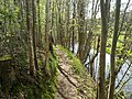
Lüneburg Heath near Niederhaverbeck

In the Südheide nature reserve Weg vom Wietzer Berg
Heidschnuckenweg on the Örtze near Poitzen
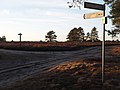
Fork in the road on the Haußelberg (118 m above sea level)

In the Südheide nature park, NSG heath areas, middle Lüß plateau
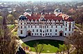
Celle Castle
.jpg)


.jpg)

Web links
- Official homepage of the Heidschnuckenweg
- Route of the Heidschnuckenweg on OpenStreetMap
- Route , on hiking.waymarkedtrails.org
- Detailed descriptions of the course of the hiking trail from Hamburg-Fischbek to Celle with photos and GPX files
Individual evidence
- ↑ Quality Trail Wanderable Germany . In: wanderbaren-deutschland.de .
- ↑ Heidschnuckenweg receives an award again. In: Hamburger Abendblatt . September 15, 2015, accessed on August 20, 2016 (for a fee).
- ^ Burkhard Straßmann: Land of the thick-skinned. In: The time . August 1, 2013, accessed August 20, 2016 .
- ↑ Germany's most beautiful hiking trail again awarded as "Quality Trail Wanderable Germany" ( Memento of the original from April 9, 2016 in the Internet Archive ) Info: The archive link was inserted automatically and has not yet been checked. Please check the original and archive link according to the instructions and then remove this notice. . In: Celler Presse . 17th September 2015.
- ↑ Katharina Gessler: Jan Brockmann is the keeper of the heath. In: Hamburger Abendblatt . April 18, 2016, accessed on August 20, 2016 (for a fee).
- ↑ Opening of the Heidschnuckenwanderweg ( Memento of the original from July 14, 2014 in the Internet Archive ) Info: The archive link was automatically inserted and not yet checked. Please check the original and archive link according to the instructions and then remove this notice.
- ↑ Yvonne Weiß: The color purple in the oldest nature reserve. In: Hamburger Abendblatt . September 2, 2013, accessed on August 20, 2016 (for a fee).
- ↑ Matthias Greulich: From Fischbek to Celle: 223 kilometers through nature. (No longer available online.) In: Elbe Wochenblatt . May 18, 2012, archived from the original on April 24, 2016 ; accessed on August 20, 2016 .