
Freudenthalweg
Coordinates: 52 ° 55 ′ 14.5 " N , 9 ° 14 ′ 13.2" E
| Freudenthalweg | |
|---|---|

|
|
| Data | |
| length | 151 km |
| location | Hamburg-Marmstorf , Klecken , Holm-Seppensen , Handeloh , Wilsede , Schneverdingen , Soltau , Dorfmark , Fallingbostel , Walsrode , Sieverdingen , Verden |
| Supervised by | Wanderverband Norddeutschland eV |
| Markers |

|
| Starting point |
Hamburg-Marmstorf 53 ° 26 ′ 11.8 ″ N , 9 ° 56 ′ 5.6 ″ E |
| Target point |
Verden 52 ° 55 ′ 14.5 " N , 9 ° 14 ′ 13.2" E |
| Type | Long-distance hiking trail |
| Viewpoints | Salongrab , Büsenbachtal , Wilseder Berg , Wilsede , Lüneburger Heide , Totengrund , nature reserve Böhmetal near Huckenrieth , Heidmark , Lönsgrab , monastery Walsrode , open-air museum Heidemuseum Rischmanns Hof , nature reserve Grundlos Moor , nature reserve Tumulus-Heide near Kirchlinteln , Magic Park Verdeninteln |
The Freudenthalweg is a 151 km long long-distance hiking trail. It leads in a north-south direction through the Lüneburg Heath from Hamburg-Marmstorf to Verden (Aller). It was named after the local writers, poets and brothers Friedrich and August Freudenthal . This hiking trail is looked after by the Northern Germany Hiking Association .
Route
The trail begins in the the district Harburg belonging district Marmstorf . The starting point is the Appelbütteler Weg bus stop , which can be reached by bus directly from Hamburg-Harburg train station . The bus stop can be reached by car via the Marmstorf exit on Autobahn 7. Freudenthalweg goes directly over the bridge over Autobahn 7 and a short time later the hiking trail also crosses Autobahn 261 and then Autobahn 1. South of Klecken you can reach it Neolithic salon tomb . The Freudenthalweg leads past the Holm-Seppensen train station into the Büsenbachtal , where the hiking trail at the Pferdekopf crosses the European long-distance hiking trail E1 as well as the Heidschnuckenweg and Heidepuzzle hiking trail. The Lüneburg Heath nature reserve begins south of Handeloh train station , right after the Inzmühlen youth hostel . The hiking trail leads through large heather areas, whose main bloom is in August, to Wilseder Berg , Wilsede with the heather museum Dat ole Huus and the Totengrund . In Wilsede there is a connection to the hiking trails E1, Heidschnuckenweg, Jakobsweg to Lüneburg, Jakobsweg Lüneburg Heath, Pastor Bode hiking trail and Lila Krönung hiking trail. The hiking trail continues through Niederhaverbeck to Schneverdingen, where there is a connection to the next train station. Along field and meadow paths it goes parallel to the river Böhme through the nature reserve Böhmetal near Huckenrieth to Soltau whose mayor Friedrich Freudenthal 1884-87 was past the Soltau thermal baths . Furthermore, the Freudenthalweg again crosses the hiking trail E1, the Heidschnuckenweg, the Jakobsweg Lüneburg Heath and the Hermann Billung hiking trail . A few meters away from the path is the Soltau train station , the Soltau local history museum and the Soltau toy museum . The Freudenthalweg continues along the Böhme through the Heidmark via Dorfmark and the Dorfmark train station, to Bad Fallingbostel and its train station. South of Dorfmark, the hiking trail passes the archaeological burial mounds of Vierden and near Lieth there is the Freudenthal monument on a plateau above the Wolfsschlucht gorge . The trail continues west of Bad Fallingbostel, still parallel to the Böhme, through the Tietlingen juniper grove to the Lönsgrab nature reserve . In Walsrode , the hiking trail leads past the train station, the Heidemuseum Rischmanns Hof open-air museum and Walsrode Monastery . At the Klostersee the hiking trail leaves the river Böhme and turns west to Sieverdingen through the nature reserve Grundlos Moor . On the bridge over the Lehrde, the hiking trail crosses the Hermann-Billung hiking trail again and south of Kirchlinteln the Freudenthalweg runs through the Hügelgräber-Heide nature reserve near Kirchlinteln . The hiking trail crosses Autobahn 27, passes Magic Park Verden and ends at Verden train station.
Condition of the hiking trail
The waymarking, as of 2011, is consistently good in both directions. Even without a map, the route can almost always be followed.
According to OpenStreetMap, the 151 km long path consists of:
- 39 km (26%) of narrow trails
- 60 km (40%) forest and meadow paths
- 43 km (28%) of asphalt paths / village streets
- 9 km (6%) country roads with footpaths.
Pictures from the hiking trail
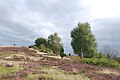
Wilseder Berg

Lüneburg Heath near Niederhaverbeck

Lönsgrab in the Tietlinger juniper grove

Schnucken herd at the foot of the Lönsdenkmal in the Tietlingen juniper grove

Open-air museum Heidemuseum Rischmannshof


Web links
- Via the Freudenthalweg from the Northern Germany Hiking Association
- Route of the Freudenthalweg on OpenStreetMap
- Route on waymarked trails
- Detailed descriptions of the route from Hamburg-Marmstorf to Verden (Aller) with photos and GPX file → Go to the edit field