
Hermann Billung hiking trail
Coordinates: 52 ° 55 ′ 2.6 ″ N , 9 ° 13 ′ 40.8 ″ E
| Hermann Billung hiking trail | |
|---|---|

|
|
| Data | |
| length | 145 km |
| location | Lauenburg , Lüneburg , Amelinghausen , Bispingen , Soltau , Neuenkirchen , Visselhövede , Verden |
| Supervised by | Wanderverband Norddeutschland e. V. |
| Markers |

|
| Starting point |
Lauenburg 53 ° 22 ′ 10.9 ″ N , 10 ° 34 ′ 1.2 ″ E |
| Target point |
Verden 52 ° 55 '2.6 " N , 9 ° 13' 40.8" E |
| Type | Long-distance hiking trail |
| Viewpoints | Lüneburg ship lift , Alter Kran , Lüneburg Kalkberg , Soltau Local History Museum , Ole Kerk , Schäferhof Neuenkirchen, Verden Cathedral |
The Hermann-Billung-Wanderweg or Hermann-Billung-Weg is a 145 km long long-distance hiking trail. It leads in an east-west direction from Lauenburg to Verden (Aller). It was named after Hermann Billung Margrave, Duke and Deputy Saxon King I. Otto named. This hiking trail is looked after by the Northern Germany Hiking Association .
Route
The Hermann Billung hiking trail goes from the train station in Lauenburg directly over the Elbe and leaves Schleswig-Holstein in the direction of Lower Saxony after just a few meters. The hiking trail goes a few meters along the southern Elbe dike and then follows the Elbe Lateral Canal , past the Bennerstedt nature reserve and the Fehlingsbleck nature reserve to the Lüneburg ship lift in Scharnebeck . Behind the Lüne monastery with its textile museum, the hiking trail goes past the Lüneburg train station and into the historic old town of Lüneburg with its old crane . A few meters away from the trail are the German Salt Museum , Natural History Museum Lüneburg and the churches of St. Michael , St. John and St. Nicolai . In the inner city of Lüneburg there is a connection to the Via Scandinavica Way of St. James and, on the Lüneburg Kalkberg, to the Way of St. James to Wilsede, the Kultur-Foundlinge hiking trail and the Pastor Bode hiking trail. You continue along the Hasenburger Bachtal nature reserve over forest and meadow paths to Amelinghausen . There is a connection to the Heidepuzzle hiking trail, the Kultur-Erlinge hiking trail and the Pastor Bode hiking trail. Through the Söhlbruch nature reserve , past the Ole Kerk church, the Hermann Billung hiking trail in Bispingen crosses the European long-distance hiking trail E1 and the Heidschnuckenweg . From Bispingen the path follows the upper reaches of the Luhe , past the Bispingen adventure playground, to the Luhe spring. The hiking trail continues through the large Cameroon forest area , through Stübeckshorn, crosses Autobahn 7 and leads through Oeningen to the Soltau thermal baths in Soltau . Here the Hermann Billung hiking trail again crosses the E1 hiking trail, the Heidschnuckenweg, the Jakobsweg Lüneburg Heath and the Freudenthalweg . A few meters away from the path is the Soltau train station , the Soltau local history museum and the Soltau toy museum . The hiking trail leads through the Riensheide past Schäferhof Neuenkirchen to Neuenkirchen . The hiking trail leads over the Höllenberg to the source of the Vissel and the St. Johannis Church in Visselhövede . The hiking trail goes along the Lehrdetal to the St. Georg Christophorus Jodokus Church in Stellichte . On the bridge over the Lehrde , the trail meets the Freudenthalweg again, runs along the Verdener Moor nature reserve and crosses the Autobahn 27 a few kilometers later. The trail follows the Gohbach to the historic Eitzer watermill in Eitze . Along the banks of the Aller , past the half-timbered house Strukturstrasse 7 , the Hermann Billung hiking trail ends at Verden Cathedral in the historic old town of Verden . The Verden train station, which is also connected to the Freudenthalweg, is about 800 m from Domplatz.
Condition of the hiking trail
The waymarking, as of 2011, in east-west direction from Lauenburg to Verden is good to mediocre. Occasionally a map is needed to follow the route. In the west-east direction from Verden to Lauenburg, the signs are only mediocre and a map is required at several crossings in order to follow the route.
According to OpenStreetMap, the 145 km long path consists of:
- 14 km (10%) narrow trails
- 65 km (45%) forest and meadow paths
- 53 km (36%) of asphalt paths / village streets
- 13 km (9%) country roads with footpaths.
Pictures from the hiking trail

Lüneburg ship lift
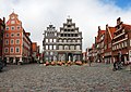
Lueneburg old town

Ole Kerk in Bispingen

Schäferhof Neuenkirchen


_-_Sch%C3%A4ferhof_31_ies.jpg)
Web links
- Via the Hermann Billung hiking trail at Wanderverband-norddeutschland.de
- Route of the Hermann Billung hiking trail on OpenStreetMap
- Route on waymarked trails