
Bispingen
| coat of arms | Germany map | |
|---|---|---|

|
Coordinates: 53 ° 5 ' N , 10 ° 0' E |
|
| Basic data | ||
| State : | Lower Saxony | |
| County : | Heidekreis | |
| Height : | 90 m above sea level NHN | |
| Area : | 128.13 km 2 | |
| Residents: | 6410 (Dec. 31, 2019) | |
| Population density : | 50 inhabitants per km 2 | |
| Postal code : | 29646 | |
| Area code : | 05194 | |
| License plate : | HK | |
| Community key : | 03 3 58 002 | |
| Community structure: | 9 districts | |
| Association administration address: | Borsteler Strasse 4-6 29646 Bispingen |
|
| Website : | ||
| Mayor : | Jens Bülthuis | |
| Location of the municipality of Bispingen in the Heidekreis district | ||
  |
||


Bispingen ( Low German / Plattdütsch Bissen ) is a unitary municipality in the middle of the Lüneburg Heath around 15 km northeast of Soltau near exit 43 of the federal motorway 7 . It is located in the district of Heidekreis in Lower Saxony (Germany).
geography
Geographical location
Bispingen is located in the north of the Heidekreis, in the upper Luhetal, exactly on the 10th meridian east longitude.
It can be reached via the federal autobahn 7, Bispingen exit, the federal road 209 and the district road K 4.
The Lüneburg – Soltau railway line , on which the town is located, currently only transports goods. However, the Osthannoversche Eisenbahn invites you to take a leisurely stroll with a special timetable. With the historical "Anteater", a 71-person railcar from 1937, it goes from Soltau via Bispingen to Döhle and back.
Local division
Bispingen is divided into the districts of Behringen , Borstel in der Kuhle , Haverbeck (Nieder- and Oberhaverbeck), Hörpel , Hützel , Steinbeck / Luhe , Volkwardingen , Wilsede , Heidedorf at the foot of the Wilseder Berg , and the core town of the municipality: Bispingen.
The core town currently has 2,451 inhabitants (as of October 2012), making it the largest village in the municipality.
Neighboring communities
Neighboring communities are Schneverdingen , Undeloh , Egestorf , Soderstorf , Rehlingen , Munster , and Soltau .
Neighboring cities are:
|
Tostedt 31 km |
Buchholz (Nordheide) 37 km |
Lüneburg , Geesthacht 39 km, 59 km |
|
Schneverdingen 17 km |
.svg)
|
Bad Bevensen 55 km |
|
Soltau 16 km |
Wietzendorf 19 km |
Munster , Uelzen 15 km, 53 km |
history
Prehistory and early history
Numerous barrows, urn fields and prehistoric finds prove that people settled in this area in prehistoric times. The oldest known document dates from 1193 and testifies to the sale of the "village with accessories" to Bishop Lüder von Verden.
The name Bispingen developed from "von Biscopinge" ("belonging to the bishop"); the ending “ingen” indicates Longobard origin and is often found in this part of Lower Saxony, the old Bardengau .
Middle Ages and Modern Times
The " Ole Kerk ", the oldest building in Bispingen, still bears witness to bygone days . It was built in 1353 on the edge of the Luheniederung from field stones and served the "Parish Bispingen" until the construction of the new church in 1908 as a place of worship.
The nine villages of Bispingen, Behringen, Borstel, Haverbeck (with Ehrhorn), Hörpel, Hützel, Steinbeck, Volkwardingen and Wilsede have always built and used a church together.
Latest time
On March 1, 1974, the Borstel community was incorporated into the Kuhle . On March 16, 1974, Behringen (with the towns of Hörpel , Volkwardingen and Wilsede added on March 1, 1974 and part of the dissolved municipality of Ehrhorn ), Hützel and Steinbeck (Luhe) were added.
The title of climatic health resort that Bispingen wore was no longer officially recognized in 2011.
politics
Municipal council
The municipal council decides in particular on the basic development goals of the municipality. It is re-elected every five years. It is composed of 18 elected councilors, who also include the mayor by virtue of their office. In the current election period 2016–2021, the distribution of seats after the local elections was as follows:
| Party / list | Seats |
|---|---|
| CDU | 8 seats |
| SPD | 4 seats |
| Alliance 90 / The Greens | 2 seats |
| Bispinger Citizen List | 4 seats |
mayor
Sabine Schlüter has been the mayor since December 1, 2010.
Jens Bülthuis has been mayor since December 1, 2018.
Community partnerships
Due to the fact that the district of Behringen had the same name with places of the same name, the first contacts between the five Beringen in Belgium, Germany, Luxembourg, the Netherlands and Switzerland began over 60 years ago. Mutual visits by association delegations took place regularly.
In 1969 the association "5 x Beringen International" was founded. The aim of this association is to maintain friendship and partnership between the five communities with the names of places or districts called Beringen, Behringen and Beringe. At the beginning of the 1990s the community expanded to seven members with the admission of the two Behringen from Thuringia. In 2014 a partnership agreement was signed between the political communities in Bispingen.
The six municipalities with the same name or with districts of the same name are:
- Beringen (Belgium)
- Beringen SH (Switzerland)
- Hörselberg-Hainich (with the district of Behringen (Hörselberg-Hainich) ), Thuringia
- Ilmtal (with the district Behringen (Stadtilm) ), Thuringia
- Mersch (with the village of Beringen), Luxembourg
- Peel en Maas (with the place Beringe in the district Helden (Limburg) ), Netherlands
Culture and sights
Buildings
- Bispingen was a typical heather farming village. The striking small bronze sculpture of a Heid shepherd in the center of the village refers to this past.
- The 10th meridian of eastern longitude runs through Bispingen. To illustrate this, there is a granite boulder from the Ice Age on Hützeler Straße. It embodies the longitude in a natural way through a circumferential band-like and color-visible silicification. Provided with explanatory data on a bronze plate, it was set up there, aligned with this, by the Bispingen home and culture association.
- A burial ground in Volkwardingen contains Bronze Age barrows .
- The Ole Kerk ("Old Church") was built in 1353 from field stones. Restored simply and stylishly, it is used today for weddings, concerts and prayer. The "Ole Kerk" is unlocked during the day and, as a haven of peace, invites everyone to quiet contemplation. The church is open daily from Easter to New Year's Eve and is also used, for example, for concerts ("Summer Music in Bispinger Churches").
- The stair store in Volkwardingen is one of the oldest of these storage buildings in the Lüneburg Heath. Its two parts of the building were built according to a bar inscription in 1600 and 1702 and restored in 2001.
- The Dat ole Huus in Wilsede , built in 1742, is one of the oldest local museums in Germany when it was founded in 1907.
- A country estate of the Noelle family, east of the village, built around the turn of the century, was first a children's home, then a bizarre hunting lodge with a landscape park that attracts thousands of visitors every year. It still bears the name " Iserhatsche " ( iron heart , Westphalian flat), which the Noelle family gave to the property.
- The St. Antonius Church was built in the neo-Gothic style in 1908 and stands in the center of the village. It contains a pulpit from 1648 and a bronze baptism from 1406.
Architectural monuments
Green spaces and recreation
- The Wilseder Berg is located in the nature reserve and is 169.2 m above sea level. NN the highest point in the Lüneburg Heath.

St.Antonius Church
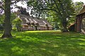
Rectory

Town view

Ole Kerk

The crazy house, upside down with all the furniture


Life in the village is shaped by a large number of active associations. There is the Bispingen volunteer fire brigade with their musical train, a rifle club that is over 100 years old, the MTV Bispingen with its marching band, the Bispingen parish, the local and cultural association, as well as many other club offers for the citizens.
Economy and Infrastructure
Companies
In terms of tourism, the heather region around Bispingen is primarily known as a local recreation and nature reserve. The village lives from a mixture of medium-sized companies, some of which operate worldwide, various trades and tourism. More people commute to Bispingen for work than they do.

There has been a youth hostel in town since the 1920s. Hotels, guesthouses, inns and restaurants shape the townscape. Some companies have become known far beyond the region for their entertainment offers:
- "Center Parcs Bispinger Heide" At the beginning of the 1990s, Bispingen became the location for a leisure facility for the " Center Parcs " company. The "Bispinger Heide" facility accommodates more than 2000 guests a day during the season.
- The “Schumachers Kart and Bowl” was built in the mid-1990s by the well-known Formula 1 racing driver Ralf Schumacher together with a local contractor at the Bispingen motorway exit as an indoor and outdoor kart track .
- The Snow Dome is a ski hall that opened in autumn 2006 and was renovated in 2013.
- The Modellbauwelten Bispingen as a model railway system on around 12,000 m² under the Snow Dome ski hall was opened in 2020
- “The crazy house” is an upside down house that opened in 2011. It is the first house in the world that was erected correctly and then turned with the help of two cranes. The entire facility is overhead.
education
Bispingen is the location of the primary and secondary schools of the unified community and has two kindergartens in the core town.
traffic
Bispingen is on the Lüneburg – Soltau railway line , but there is no passenger traffic on it. The closest train stations with passenger traffic are Soltau , Schneverdingen and Munster . The long-distance bus provider Flixbus offers connections in the direction of Hanover and Hamburg. The regional bus traffic is u. a. carried out by KVG Stade (KVG) and Verkehrsbetriebe Osthannover GmbH (VOG).
The Bispingen exit / junction is on the A7.

In Bispingen, some passenger benches have been set up to improve the mobility of people without a car (such as the elderly, young people) . In particular, this should enable additional, free connections to Schneverdingen and Behringen.
Personalities
- Pastor Wilhelm Bode (1860–1927) is considered to be one of the founding fathers of the nature reserve. In 1905 he ensured that the Totengrund was not sold and built on as building land, but was placed under nature protection.
- The conservationist Ernst Preising (1911–2007) spent the last years of his life here.
- Waldemar Grube (1915–2001), founder of Grube KG forest equipment office
- Songwriter and composer Wolfgang Mürmann was born in Hützel in 1944 .
Web links
Individual evidence
- ↑ State Office for Statistics Lower Saxony, LSN-Online regional database, Table 12411: Update of the population, as of December 31, 2019 ( help ).
- ^ Federal Statistical Office (ed.): Historical municipality directory for the Federal Republic of Germany. Name, border and key number changes in municipalities, counties and administrative districts from May 27, 1970 to December 31, 1982 . W. Kohlhammer GmbH, Stuttgart / Mainz 1983, ISBN 3-17-003263-1 , p. 235 and 236 .
- ^ Portrait of the Bispingen community: Local council , accessed on June 4, 2020
- ↑ https://www.nwzonline.de/wilhelmshaven/sabine-schlueter-wird-buergermeisterin_a_1,0,741514204.html
- ↑ http://www.boehme-zeitung.de/lokales/news/artikel/bispingen-hat-einen-neuen-buergermeister.html
- ^ Website of the Bispingen municipality - partner municipalities , accessed on June 4, 2020
- ↑ Model building worlds in Bispingen open at the beginning of July at ndr.de from June 25, 2020
- ↑ The Crazy House
Ahlden (Aller) | Bad Fallingbostel | Bispingen | Böhme | Buchholz (Aller) | Eickeloh | Essel | Frankenfeld | Gilten | Grethem | Hademstorf | Häuslingen | Hodenhagen | Lindwedel | Munster | Neuenkirchen | Rethem (Aller) | Schneverdingen | Schwarmstedt | Soltau | Walsrode | Wietzendorf
Non- parish district in the district of Heidekreis
Osterheide