
Borstel in the hollow
|
Borstel in the hollow
Bispingen municipality
Coordinates: 53 ° 6 ′ 9 ″ N , 10 ° 0 ′ 16 ″ E
|
||
|---|---|---|
| Height : | 16– m above sea level NN | |
| Incorporation : | March 1, 1974 | |
| Postal code : | 29646 | |
Location of Borstel in the Kuhle in Lower Saxony |
||

_IMG_0171.jpg)
Borstel in der Kuhle is a district of the municipality of Bispingen in the Lüneburg Heath in the Heidekreis district in Lower Saxony .
geography
The Borsteler Kuhlen denote a deeply rugged landscape east of Borstel, which was formed here by glaciers from the Ice Age. The so-called "Borsteler Schweiz" offers particularly attractive heathland landscapes.
The Brunau , a 10.3 km long tributary of the Luhe, flows through the village .
history
The name of the village Borstel is derived from "bûrstal", which means something like a house or a farm.
Borstel was first mentioned in a document in 1193, but a much older settlement can be assumed to be certain due to the many sites of Bronze Age burial mounds in the vicinity of the place.
On March 1, 1974, Borstel in the Kuhle was incorporated into the Bispingen community.
politics
The mayor of Borstel is Jürgen Fiedler.
Culture and sights
- To the east of Borstel in the Kuhle there is an area formed by glaciers from the Ice Age into a rugged mountain and valley landscape. The resulting attractive heather area is also called Borstel Switzerland .
- In the grove above the Kuhlen area is the cultural monument of a prehistoric burial mound from the older Bronze Age between 2000 and 1600 BC. BC, which contains at least three burials.

View of the Brunau

Town view
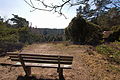
Borsteler Switzerland

Prehistoric burial mounds
_IMG_0170.jpg)
_IMG_0169.jpg)
_IMG_0183.jpg)
_IMG_0191.jpg)
Economy and Infrastructure
Despite the agricultural character of Borstel, only two of the original seven farms still exist.
A biogas plant produces alternative energy in the village. The Brunautal-Ost motorway service station and the “Snowdome” ski facility are also located in the Borstel area.
The place where there are no street names is on the L 212 , which leads from Bispingen (core area) to Garstedt and Wulfsen . The A 7 runs two kilometers to the west.
Web links
Individual evidence
- ^ Federal Statistical Office (ed.): Historical municipality directory for the Federal Republic of Germany. Name, border and key number changes in municipalities, counties and administrative districts from May 27, 1970 to December 31, 1982 . W. Kohlhammer, Stuttgart / Mainz 1983, ISBN 3-17-003263-1 , p. 235 .
- ^ Head of Borstel in the Kuhle