
Wilseder Berg
| Wilseder Berg | ||
|---|---|---|
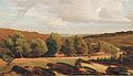
 View of the Wilseder Berg |
||
| height | 169.2 m above sea level NHN | |
| location | Lower Saxony , Germany | |
| Dominance | 94.9 km → Benther Berg | |
| Notch height | 144 m ↓ SW of Thören (Aller) | |
| Coordinates | 53 ° 10 '3 " N , 9 ° 56' 23" E | |
|
||
| Type | Terminal moraine of the Saale Ice Age | |

The Wilseder Berg near Wilsede is 169.2 m above sea level. NHN the highest point in the Lüneburg Heath .
description
The Wilseder Berg lies within the Lüneburg Heath nature reserve in the Lüneburg Heath and is close to Wilsede and Bispingen in the Heidekreis district . The elevation arose during the penultimate Ice Age , the Saale Ice Age ; it is part of a terminal moraine . The mountain has an extensive high plateau and a flat peak. At the edges it is diverse with hollows, valleys and small gorges.
The soils in the area consist of washed-out, gritty-sandy soils with layers of local stone . There are open sand areas, large heathland areas and extensive coniferous forests. The heaths are of moorland sheep grazed.
There is a watershed on the Wilseder Berg . The source streams of several rivers emerge here, such as those of the Este , Luhe , Wümme and Böhme . Some of the waters lead to the Weser river system , others to the Elbe .

On the summit plateau there is a summit stone on which there is a metal cone: the so-called "Gauss column". In the metal cone, directions and distances to neighboring elevations as well as to cities closer and further away are engraved. This orientation table was designed by the Hamburg geographer Wilhelm Precht. The Gauss column was set up in 1925 by the Association of North German Wanderers.
The summit of the Wilseder Berg naturally offered a different sight in the past than it is today. In the 1860s, 7 spruce trees were planted there as landmarks to emphasize the Wilseder Berg in the hilly landscape. Emil Stender put the number of trees in the autumn of 1889 at five in his hiking guide walks around Hamburg , between 1904 and 1906 there were three spruces and by 1910 only one tree was left of these spruces. The heather fire in 1920 affected this tree, so that it stood until around 1926. In 1977 Walter Gröll wrote that a red beech was growing as a new signal tree on the Wilseder Berg.
Survey point

In 1820, the then King George IV commissioned the professor of astronomy and director of the observatory at the University of Göttingen, Carl Friedrich Gauß , to measure the Kingdom of Hanover . Gauss also used the summit of the Wilseder Berg as one of the points of triangulation for the land survey . Further central triangular points were formed by the Falkenberg ( 150 m above sea level ) further south and the Haußelberg ( 118 m above sea level ) to the east . For the purpose of land surveying, a "triangulation tower" was built on the summit of the Wilseder mountain. It is unclear whether this tower had to be demolished at the beginning of the 1890s or at the end of the 1890s because it was dilapidated. After that, between 1900 and 1906 there was a signal pole on the Wilseder Berg, which is documented on a postcard sent in 1904 (together with three of the former seven signal spruces). A photo taken around 1910, however, no longer shows this signal pole (and only a signal spruce).

A part of the triangular network of the Gaussian degree measurement , with the Wilseder Berg, was also shown on the reverse of the 10 DM banknote of the fourth series of the Deutsche Mark .
Surroundings
Dead and stone ground
The most famous deepening on the mountain is the several hectare large Totengrund south of the museum village of Wilsede. It is a basin with flanks up to 40 meters high, today covered with heather and juniper bushes. The designation as dead ground can be traced back to the fact that its soil was not very fertile for the farmers, i.e. dead, because the valley is very arid. The Totengrund was the nucleus of today's nature reserve when the Egestorf pastor Wilhelm Bode bought it in 1906 with donations. After Bode's death in 1927, his ashes were scattered on the Wilseder Berg.
Another valley is the Steingrund , a typical dry valley of the heathland, which is heavily covered by stones deposited during the Ice Age.

Dead ground

Stone ground


In the legendary world of the Lüneburg Heath, Toten- und Steingrund are linked to the struggle of two hostile and militarily organized giant groups: the one from Reinsehlen and the one from one in the legend "'The giant battle between Reinsehlen and one" or "How the Steingrund near Wilsede arose" "Or" The Totengrund near Wilsede ". In the course of this fight, about the outcome of which the legend has nothing to report, the Einser giants used sand as a weapon against their opponents, with the result that the once fertile area at Reinsehlen was covered with sand. The Reinsehlen giants, shrouded in clouds of dust, defended themselves by throwing large stones, which they threw eastward to where they could only suspect the enemy. Most of the stone bullets failed to hit their target. “The rocks flew too far and only went back to the ground behind Wilsede , where they rolled thundering into a long, wide valley and filled it. To this day, this valley is called the Stone Ground, because the stones lie there as if sown. [...] But the fallen giants were then buried in a deep ravine, which today is called the bottom of the dead ”.
Bolterberg and Stattberg
1.3 km southwest of the summit of the Wilseder Berg lies the second highest mountain in the Lüneburg Heath : the Bolterberg ( 160.2 m above sea level ). Approx. 500 m further in the same direction, but outside the network of paths that must not be left in the nature reserve, is the Stattberg ( 145 m above sea level ), the third highest mountain in the nature reserve.

Summit stone on the Bolterberg in the Lüneburg Heath nature reserve

Southwest view from the summit of Bolterberg in snow


tourism
The idyllic landscape ensures a pronounced tourism. The Wilseder Berg can be reached by horse-drawn carriages from Oberhaverbeck , Niederhaverbeck , Undeloh , Döhle or Sudermühlen and on foot from Volkwardingen . With clear visibility you can see the Hamburg TV tower on the horizon . There is also a good view of the heather to the west and north.
On New Year's Eve, there is a tradition of hiking up the Wilseder Berg to see the fireworks from the surrounding villages and - in good weather - those from Hamburg and Bremen. Since the Wilseder Berg lies in the middle of the Lüneburg Heath nature reserve , any kind of fireworks display is strictly forbidden there, which is controlled by the police.
Picture gallery
Wilseder Berg, painting by Valentin Ruths (1825–1905)

Oil painting by Heinrich Vogeler (1910)

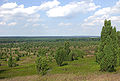
View to the north from Wilseder Berg
Blueberry sand heather on the north slope

Heath apiary near the Wilseder Berg


literature
- Ernst Andreas Friedrich : Natural monuments of Lower Saxony . Hanover, 1980. ISBN 3-7842-0227-6
Individual evidence
- ^ A b Walter Gröll: Through the Lüneburg Heath. Fun and interesting facts about the country and its people . Verlag Hans Christians, Hamburg 1977, p. 55 .
- ↑ a b c d Walter Gröll: The Lüneburg Heath in old views . European Library, Zaltbommel / Netherlands 1977 (text for illustration no. 71 (photograph) - without page counting).
- ^ Emil Stender: Walks around Hamburg. Collected notes from a nature lover . In addition to 2 appendices: Our most important forest trees. From Prof. Dr. Ludwig Reh. Landscape studies for Hamburg hikers. From Dr. Karl Gripp. Salzwasser-Verlag, Paderborn 2012, p. 141 (reprint of the original from 1925).
- ↑ a b c d Walter Gröll: The Lüneburg Heath in old views . European Library, Zaltbommel / Netherlands 1977 (text for illustration No. 70 (postcard) - without page counting).
- ↑ Overview of the measured triangular systems in Northern Germany
- ^ Emil Stender: Walks around Hamburg. Collected notes of a nature lover . In addition to 2 appendices: Our most important forest trees. From Prof. Dr. Ludwig Reh. Landscape studies for Hamburg hikers. From Dr. Karl Gripp. Salzwasser-Verlag, Paderborn 2012, p. 142 (reprint of the original from 1925).
- ↑ 10 DM note, on the reverse: sextant and triangular network (far right in the middle of the Wilseder Berg)
- ^ Pastor Bode. In: Lueneburger-Heide.de , accessed on July 25, 2016.
- ↑ Heinrich Schulz : A Tell wreath around Luhe and Aue (= Winsener Geschichtsblätter . Band 15 ). Ravens brothers, Winsen (Luhe) 1933, p. 31 .
- ^ Wilhelm Marquardt: Legends, fairy tales and stories of the Harburg district. Volume 2 (= publications of the Helms Museum . Volume 16 ). Publishing house Dr. Johannes Knauel, Buchholz 1963, p. 54-56 .
- ^ Wilhelm Marquardt: Of giants, robbers and witches. Legends and fairy tales from the land between the Elbe and Aller . Convent, Hamburg 2001, p. 122-123 .
- ↑ Heinrich Schulz : A Tell wreath around Luhe and Aue (= Winsener Geschichtsblätter . Band 15 ). Ravens brothers, Winsen (Luhe) 1933, p. 9 .
Web links
- Landscape profile Wilseder Berg of the Federal Agency for Nature Conservation ( information )