
Undeloh
| coat of arms | Germany map | |
|---|---|---|

|
Coordinates: 53 ° 12 ' N , 9 ° 59' E |
|
| Basic data | ||
| State : | Lower Saxony | |
| County : | Harburg | |
| Joint municipality : | Hanstedt | |
| Height : | 85 m above sea level NHN | |
| Area : | 48.23 km 2 | |
| Residents: | 1005 (Dec. 31, 2019) | |
| Population density : | 21 inhabitants per km 2 | |
| Postcodes : | 21274, 29640 | |
| Area code : | 04189 | |
| License plate : | WL | |
| Community key : | 03 3 53 036 | |
| Community structure: | 6 districts | |
| Address of the municipal administration: |
Wilseder Strasse 7 21274 Undeloh |
|
| Website : | ||
| Mayor : | Albert Homann | |
| Location of the municipality of Undeloh in the Harburg district | ||
  |
||

Undeloh (Niederdt. Unnel ) is a municipality in the Harburg district in Lower Saxony .
geography
Undeloh is located in the North German Plain in the Lüneburg Heath four kilometers northeast of Wilseder Berg at an altitude of 85 m above sea level. NN . The Seeve , the Weseler Moorbach, the Weseler Bach, the Radenbach and the Wilseder Bach flow through the municipality .
Undeloh's neighboring communities are Handeloh , Buchholz , Hanstedt , Egestorf , Bispingen and Schneverdingen .
history

The municipality of Undeloh consists of six districts: Undeloh, Wehlen, Wesel, Meningen, Thonhof and Heimbuch. As the last district, the former neighboring municipality of Wehlen was incorporated in the course of the municipal reorganization on July 1, 1972.
Place name
The name Undeloh means "spring grove". In his monograph Das Undeloher Dorfbuch, Reins names the original name of the place as "Undealoh" (source grove = forest at the source of the Radenbach) ", which is of Lombard origin.
Residents
Around 950 people live in Undeloh on an area of 48.2 km².
politics
Municipal council
The municipal council is composed as follows (status: 2011 local elections ) :
coat of arms
Blazon : Red bell tower with a green roof on a green shield base and in the right black field a gold deer antler with a silver skull.
On the one hand the landmark of the village Undeloh (bell tower) and on the other hand with the golden deer antlers a "part of the coat of arms of the former municipality Wehlen" is shown.
Culture and sights
The place is with typical heather houses in the middle of the nature reserve Lüneburg Heath . The St. Magdalenen Church can be found in the center of the village. It was built in 1189 and is one of the most beautiful heather churches with the bell tower standing apart. Concerts are held here in the summer months. Thatched half-timbered houses are well worth seeing in the village .

Thatched half-timbered house

Traditional barn

Old village oak in the center

Heidekirche St. Magdalenen
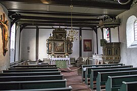
Interior St. Magdalenen

Wesel witch house


_01.jpg)

The Hunger Pohl

Until the 1930s there was a “small natural wonder” in Undeloh: a pond east of the village center, which was called “Hungerpohl” because it was completely waterless when it was constantly raining, but “completely clear when it was very dry Water ". In describing the phenomenon in the monograph Das Undeloher Dorfbuch, Reins refers to traditions according to which “ prices would rise when the pond was filled with water. Merchants from Hamburg and Lüneburg are said to have used the water level of the Undeloher Hungepohl when trading in earlier times ”. A full pond had the consequence that the sale of grain had been withheld because the merchants "definitely expected a rise in prices". This natural phenomenon, which has not existed since 1930, was traced back to the sources of the pond, which “only came to light during long periods of drought. The Hungerpohl dried up completely in the wet summer of 1910, while it overflowed several times in the dry summer of 1911. "
Economy and Infrastructure
tourism

Undeloh is a popular heather excursion destination, especially for the greater Hamburg area. Restaurants and cafés cater for day visitors, and overnight stays are possible in several hotels and the former youth hostel. The Heath Experience Center provides information on the formation of the heather in the Ice Age up to current maintenance measures.
There are several providers of carriage rides in Undeloh. Other providers can be found next to the parking lot on the outskirts on the Wilseder Straße , which is closed to traffic, in the coach parking lot .
Bicycles and e-bikes can be rented in Undeloh.
Guided walking or cycling tours lead to the most beautiful places in Undeloh and the surrounding area or are ideal for healthy hikes in the heath.
Cycling, hiking and riding trails
Several of these paths cross the forest and heather area on the Fahlenberg west of Undeloh (height 80 meters). The respective path markings as well as general signposts with information on distances to the surrounding towns and hamlets facilitate orientation. These are u. a. the European hiking trails E1 and E9 , the cycling trail Bispingen 4 , the Nordic walking trail 165 , the Reitweg Heide-Route , the Freudenthalweg and the Heidschnuckenweg
Seeve cycle path
The Seeve cycle path leading to the Elbe crosses the municipality of Undeloh with its southern ring. At the hiking car park on the northern edge of the Fahlenberg (access only from Wesel in the direction of Wehlen ), an information board indicates the route and sights.
Naturist Path

The Undeloh naturist trail was set up by the municipality for nude hiking in nature. Its 10 km long “b” -shaped course is marked with a yellow “N” in both directions from the hikers' car park (see above). The possible "added tourist value for the region" is not realized. There is no reference to the existence of the Naturist Path either on the Undeloh website or in the village. There are also no signs at the driveway, the hiking car park or on the common course or at intersections with the above-mentioned paths. The reason is a corresponding lack of interest on the part of the community. The loop of the naturist path is almost 7 km long. It can also be hiked from the surrounding areas.
The nearby forest area of Süsing , bordering Glüsingen (Betzendorf), offers further nude hiking options . It has been used by nude hikers for decades .
The Naturistenweg is the second facility of its kind after the Harzer Naturistenstieg , but the first and only one in the old federal states. Due to the tranquility and solitude of the Lüneburg Heath, it is no coincidence that he is in the vicinity of the Lichtheideheim Glüsingen and former facilities such as the Sonnenland in Egestorf or the Lichtschulheim Lüneburger Land of the educator Dr. Martin Fränzel in Glüsingen.
Educational trails
In Undeloh and Wesel, these 7.2 and 6.2 km long paths lead through typical parts of the heath cultural landscape.
traffic
The closest motorway is federal motorway 7 - accessible via the Egestorf junction. While the closest train station is in Handeloh (11 km), there are better trains in Buchholz (22 km). Undeloh is connected to Egestorf and Salzhausen via the KVG Stade regional bus line 420, which is part of the Hamburger Verkehrsverbund (HVV) . Public school buses, lines 4611 and 4631, go to the schools in Egestorf, Hanstedt and Buchholz.
Controversy over asylum seekers' accommodation in 2013
At the beginning of 2013, the Harburg district planned to accommodate 29 asylum seekers in Undeloh. The local council rejected this unanimously. In the course of the public debate, among other things, the impairment of the townscape and the resulting danger for tourism and real estate trading through the presence of people with phenotypic characteristics or cultural customs that differ from the locals were cited as arguments, which was also reported in national media. In May 2013, the Harburg district in the neighboring municipality of Hanstedt found a solution that was supported and implemented by the local population.
Web links
Individual evidence
- ↑ State Office for Statistics Lower Saxony, LSN-Online regional database, Table 12411: Update of the population, as of December 31, 2019 ( help ).
- ^ Federal Statistical Office (ed.): Historical municipality directory for the Federal Republic of Germany. Name, border and key number changes in municipalities, counties and administrative districts from May 27, 1970 to December 31, 1982 . W. Kohlhammer, Stuttgart / Mainz 1983, ISBN 3-17-003263-1 , p. 229 .
- ↑ Ehrich Reins: The Undeloher village book . With a contribution by Arnold Diesselhorst. Association for nature conservation V., Hamburg 1967, ISBN 3-440-83009-8 , p. 5 .
- ↑ Coat of arms with descriptions. Joint municipality of Hanstedt. Retrieved February 22, 2016 .
- ↑ LHG: Undeloh - romantic heath place directly in the nature reserve Lüneburg Heath. In: lueneburger-heide.de. Lüneburger Heide GmbH, accessed on July 5, 2015 .
- ↑ a b c Ehrich Reins: The Undeloher village book . With a contribution by Arnold Diesselhorst. Association for nature conservation V., Hamburg 1967, p. 51 .
- ↑ a b c Ehrich Reins: The Undeloher village book . With a contribution by Arnold Diesselhorst. Association for nature conservation V., Hamburg 1967, p. 52 .
- ↑ Gerhard Lüer's house. (No longer available online.) Archived from the original on April 3, 2017 ; accessed on May 12, 2017 . Info: The archive link was inserted automatically and has not yet been checked. Please check the original and archive link according to the instructions and then remove this notice.
- ↑ Tourist Information Undeloh, leaflet Right in the middle of the Lüneburg Heath Nature Park
- ↑ Freudenthal hiking trail. Retrieved May 31, 2017 .
- ↑ Heidschnuckenweg Hamburg - Celle. Retrieved May 30, 2017 .
- ↑ Seeve cycle path through the heath. Retrieved May 12, 2017 .
- ↑ Naturist trail for nude hikers. Retrieved May 12, 2017 .
- ^ Action of the community wg. Marking of the naturist path. Retrieved May 12, 2017 .
- ↑ NDR report on route marking. Retrieved May 12, 2017 .
- ↑ Information from Mayor Homann on November 7, 2017
- ↑ Hiking map for naked hiking in Süsing. Retrieved November 25, 2017 .
- ↑ Lichtheideheim. Retrieved May 12, 2017 .
- ^ Sonnenland Egestorf. Retrieved May 12, 2017 .
- ↑ Lichtschulheim Lüneburg Land (LLL). (PDF) Retrieved May 12, 2017 .
- ↑ Tourist Information Undeloh, leaflet Right in the middle of the Lüneburg Heath Nature Park
- ↑ Sascha Mummenhoff: "Who will protect our women from asylum seekers?" In: Kreiszeitung-wochenblatt.de. Kreiszeitung Wochenblatt, February 5, 2013, accessed on July 5, 2015 .
- ^ NDR: Undeloh: A village and the racism allegations. (Video 7m10s) In: Panorama 3. Norddeutscher Rundfunk, February 19, 2013, accessed on July 5, 2015 .
- ^ NDR: Doubtful protest: Do citizens prevent asylum accommodation? (Video 5m25s) In: Panorama 3. Norddeutscher Rundfunk, May 14, 2013, accessed on July 6, 2015 .
Appel | Asendorf | Bendestorf | Brackel | Buchholz in the north heath | Dohren | Drage | Drestedt | Egestorf | Eyendorf | Garlstorf | Garstedt | Gödenstorf | Halvesbostel | Handeloh | Hanstedt | Harmstorf | Heidenau | Hollenstedt | Jesteburg | Kakenstorf | Koenigsmoor | March shaft | Marxen | Moisburg | New Wulmstorf | Otter | Regesbostel | Rose garden | Salzhausen | Seevetal | Place | Tespe | Toppenstedt | Tostedt | Undeloh | Vierhöfen | Wave | Wenzendorf | Winsen (Luhe) | Wistedt | Wulfsen