
Welle (Lower Saxony)
| coat of arms | Germany map | |
|---|---|---|

|
Coordinates: 53 ° 14 ' N , 9 ° 48' E |
|
| Basic data | ||
| State : | Lower Saxony | |
| County : | Harburg | |
| Joint municipality : | Tostedt | |
| Height : | 49 m above sea level NHN | |
| Area : | 19.94 km 2 | |
| Residents: | 1198 (Dec. 31, 2019) | |
| Population density : | 60 inhabitants per km 2 | |
| Postal code : | 21261 | |
| Area code : | 04188 | |
| License plate : | WL | |
| Community key : | 03 3 53 038 | |
| Address of the municipal administration: |
Hauptstrasse 25 21261 Welle |
|
| Website : | ||
| Mayor : | Gerd Schröder | |
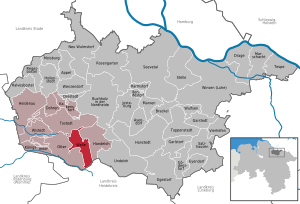
| Location of the community of Welle in the district of Harburg | ||
  |
||


The community of Welle (Low German Will) is located in the Harburg district in Lower Saxony .
geography
Geographical location
The river Este and the streams Kampener Bach and Fuhlaubach flow through a wave at the southern end of the Harburg Mountains . Welle is at the intersection of B 3 and L 141 between Sprötze and Wintermoor .
Neighboring communities
Community structure
The districts of Welle, Kampen, Kamperlien and Hoinkenbostel as well as the homesteads Cordshagen, Kamperheide and Hassel belong to the community of Welle.
Incorporations
On July 1, 1972, the neighboring municipality of Kampen was incorporated.
politics
Municipal council
The municipal council, which was elected on September 11, 2011, is composed as follows:
(As of: local election on September 11, 2011 )
coat of arms
Blazon : Divided by blue and green by a silver wavy bar. Above a silver windmill, below a golden post horn.
The coat of arms of the community of Welle consists of a mill in the upper part of the coat of arms on a blue background. This is separated from the lower part by an illustrated river (Este). In the lower area there is a yellow post horn on a green background, which is a symbol for the former horse transformer station of the Post (Celle-Hamburg line). The mill is a symbol for the mill in the Kampen district.
Sports
Turnverein Welle e. V.
Various sporting events from the Tostedt community take place in the multi-purpose hall of the "Sports facilities on the Loh". There are also two soccer fields (one of them with floodlights), a 400-meter running track, long jump and shot put facilities. One division is the tennis department. Your four tennis courts (three of them with floodlights) are right next to the other sports facilities.
Shooting club
Shooting is also represented in the community of Welle. With around 350 members, the shooting club Kampen und Umgegend e. V. from 1921 to the largest number of members in the region. The shooting festival takes place every year on the weekend of the fourth Sunday in July.
Economy and Infrastructure
traffic
Road traffic
Welle is at the intersection of Bundesstrasse 3 and Landesstrasse 141.
Local public transport
Welle does not have a regular local transport connection, there are only school buses to Handeloh , Tostedt and Buchholz and a bus to the Airbus plant in Hamburg-Finkenwerder . On working days, the collective call taxi (AST) of the Tostedt municipality can be used. The Hamburg-Buchholz-Soltau bus line, which also drove through Welle via the B 3 , was discontinued in 2001 with reference to low passenger numbers and the Heidebahn running parallel to it.
Rail transport
The closest train stations are Handeloh (3 km) on the Heidebahn and Tostedt (7 km) on the main Hamburg-Bremen line .
Volunteer firefighter
In the volunteer fire brigade Welle are currently 50 comrades on their active duty, there is also a youth fire brigade . As a base fire brigade, the fire brigade has a fire fighting group vehicle LF 10, which replaced a 30-year-old LF 16TS in November 2014. Furthermore, an upside in service 2008 pumper TLF 20/40 and an upside in 2004 into service crew transport vehicle stationed in MTF shaft.
Individual evidence
- ↑ State Office for Statistics Lower Saxony, LSN-Online regional database, Table 12411: Update of the population, as of December 31, 2019 ( help ).
- ^ Federal Statistical Office (ed.): Historical municipality directory for the Federal Republic of Germany. Name, border and key number changes in municipalities, counties and administrative districts from May 27, 1970 to December 31, 1982 . W. Kohlhammer GmbH, Stuttgart / Mainz 1983, ISBN 3-17-003263-1 , p. 229 .
Web links
Appel | Asendorf | Bendestorf | Brackel | Buchholz in the north heath | Dohren | Drage | Drestedt | Egestorf | Eyendorf | Garlstorf | Garstedt | Gödenstorf | Halvesbostel | Handeloh | Hanstedt | Harmstorf | Heidenau | Hollenstedt | Jesteburg | Kakenstorf | Koenigsmoor | March shaft | Marxen | Moisburg | New Wulmstorf | Otter | Regesbostel | Rose garden | Salzhausen | Seevetal | Place | Tespe | Toppenstedt | Tostedt | Undeloh | Vierhöfen | Wave | Wenzendorf | Winsen (Luhe) | Wistedt | Wulfsen