
Salzhausen
| coat of arms | Germany map | |
|---|---|---|

|
Coordinates: 53 ° 13 ' N , 10 ° 10' E |
|
| Basic data | ||
| State : | Lower Saxony | |
| County : | Harburg | |
| Joint municipality : | Salzhausen | |
| Height : | 27 m above sea level NHN | |
| Area : | 34.74 km 2 | |
| Residents: | 4870 (Dec. 31, 2019) | |
| Population density : | 140 inhabitants per km 2 | |
| Postal code : | 21376 | |
| Area code : | 04172 | |
| License plate : | WL | |
| Community key : | 03 3 53 030 | |
| LOCODE : | DE SZU | |
| Community structure: | 4 districts | |
| Address of the municipal administration: |
Rathausplatz 1 21376 Salzhausen |
|
| Mayor : | Elisabeth Mestmacher (UWG) | |
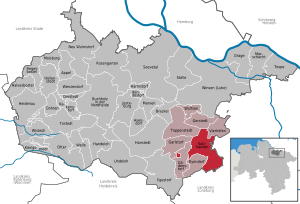
| Location of the municipality of Salzhausen in the Harburg district | ||
  |
||

Salzhausen is a municipality in the Harburg district in Lower Saxony and belongs to the Hamburg metropolitan region .
geography
location
Salzhausen is located on the northeast edge of the Lüneburg Heath nature reserve and in the southeast of the Harburg district on the border with the Lüneburg district . The place lies in the glacial moraine landscape, the Hohe Geest . The German Alps – Baltic Sea holiday route runs through the town .
Community structure
The districts of the municipality of Salzhausen are:
history
In the Salzhausen district of Putensen there are two historical Putensen burial grounds , which date from around 450 BC. To be dated. The oldest settlements can be traced back to Saxon buildings around 400 AD, Salzhausen was first mentioned in a document in 1057.
The name of Salzhausen changed in later mentions of Solthinghusen via Soltzeneshusen and Soltzhusen (around 1582) to today's Salzhausen.

In 1643 the Romanesque St. John's Church was built from field stones with a half-timbered back, the round tower dating from 1464. A bronze baptismal font from 1403 has been preserved and can be viewed.
Due to the spatial unity of church, court and administration, Salzhausen developed into a central location. In the course of a regional reform, Salzhausen became the seat of an office in 1852. The representative office building, which is adorned with the coat of arms of King George V (Hanover) , was only used for seven years. After it had long served as a justice of the peace and police station ( Landdragoner ), the only cooperative hospital in Germany, which no longer exists, was established in 1907.
In the years after the Second World War, Salzhausen mastered the refugee problem with the integration of 708 displaced persons and 104 refugees from the Soviet occupation zone (later GDR ) with only 1015 inhabitants.
In 1972, 13 formerly independent villages were finally merged to form the joint municipality of Salzhausen ( administrative and territorial reform ). Little consideration was given to old historical concerns. Previously independent villages with less than 500 inhabitants were connected to other larger communities.
Incorporations
On July 1, 1972, the communities Luhmühlen, Oelstorf and Putensen were incorporated.
Culture and sights
building

Fire department hose tower
The fire brigade hose tower and the Sprüttenhus (spray house) next to it were built in 1870/80. The hose tower was used by the fire brigade to dry their water hoses made of linen. They hung them over wooden beams in the top of the tower and let them dry for days in the narrow shaft. In the neighboring building, the syringe house, was the hand pressure syringe, which was brought to the scene by horses.
The three oldest houses
- The Josthof was built in 1252. It was destroyed by fire in April 2017. The lord of the Josthof was the Bishop of Verden , who was entitled to the delivery of fresh trout from the Luhe to the farm - his table goods . The Josthof was named after Jost Helmeke , who was born in the March in 1595 . He was married to the niece of the courtier Witte , who had been running the farm until then. In 1699 Claus Harms applied for the concession for the third Dorfkrug (inn) in Salzhausen. When the license was granted, there was a questionnaire in the village, which found that two village jugs were enough for the 250 people and 27 houses in the village. Claus Harms prevailed against this rejection with his apparently better relations with the responsible office in Winsen.
- The oldest Benthacken house was built around 1220. It used to be in Lindenberg Street, but in 1915 it was moved to Lüneburger Strasse (house number 1), where it still stands today.
- Like the Josthof, the Helpen farm was built in 1252 by the Bishop of Verden . This house can be seen as the residential building Im Winkel 6.

The Dbodschün
In the middle of the village behind the church is the Dbodschün ( Low German for village barn), which was built in 1778. It belonged to a Heidehof that still exists today. However, since 1983 this barn has been used for private and cultural purposes.
House of the guest
The library used to be in today's guest house before it moved into a new building at the school center. The house belonged to Gerhard Denckmann, who bequeathed it to the community along with his remaining assets and which flowed into the Dr. Gerhard Denckmann Foundation. Today the house houses his book collection, offers reading rooms and changing exhibitions.
Churches and other structures
- St. Johannis the Baptist Church in Salzhausen with stained glass by Charles Crodel , 1967
- New Apostolic Church on Paaschberg
- Amtshaus (today a cooperative hospital in Germany)
- Lookout tower on the Paaschberg
Parks and recreation

- The Paaschberg (Paschberg) ( ⊙ ) is a 67 m high hill, which is around 500 m (as the crow flies ) southeast of the center and surrounded by houses in the village. According to legend, the elevation arose from the fact that a Roman general cursed God, who then conjured up a sandstorm and buried the general along with a golden carriage and six horses. During the construction of the primary school at the southeast foot of the hill in 1950, a candlestick was actually found as an addition to a Roman warrior's grave, which was dated to 100 AD and possibly founded the legend. During the Second World War , a bunker was built in the elevation, which was in operation from 1939 to 1945. Between 1960 and 1980 this was used as a water reservoir, so that old water fittings can be found in the bunker. The bunker consists of two floors, of which the upper one was subsequently reduced so that only the front part, where the entrance to the basement is located, is accessible. Today it is empty, the entrance is permanently locked, but the air pipes for the oxygen supply are still visible! On the wooded summit, directly above the bunker, there is already the second wooden observation tower with 85 steps. From the village center you have to walk around ten minutes to the summit. The path is designed as a sculpture path on the hill.
- The Gallaberg is an elevation and site of a medieval execution site.
- There is a landscape protection area between Salzhausen and Garstedt .
societies
Salzhausen rifle company

The Schützenkompanie e. V. in Salzhausen was founded in 1864. The club had nineteen members when it was founded in 1864, and currently (as of July 11, 2012) around 265 shooters are registered. It appeals to all age groups, with special emphasis on youth work and participation in competitions.
Other clubs
- MTV Salzhausen
- KuKuK e. V. Art Association. On almost 200 square meters, the association offers courses for young and old in the "basement atelier". Painting, handicrafts and handicrafts are part of the course offerings. The club has a spacious painting room. Courses in watercolor, acrylic and oil take place here. With over 12 sewing stations and over and cover locks, the association is the largest course room in the district that can be offered in the field of sewing. The association has always organized children's birthdays and holiday programs. Exhibitions and vernissages are organized regularly by the association. The association appeals to all age groups.
Memorials

The memorial for the fallen soldiers of the Second World War from the Salzhäuser area is located on the wall of the churchyard.
politics
Municipal council
The town council from Salzhausen consists of 14 councilors and councilors.
- UWG 1 seat
(As of: local election on September 11, 2011)
Integrated municipality of Salzhausen

The municipality in the district of Harburg is the administrative seat of the joint municipality of Salzhausen, founded in 1972, with the (total of thirteen) municipalities of Eyendorf , Garlstorf , Garstedt , Gödenstorf , Salzhausen, Luhmühlen , Toppenstedt , Vierhöfen and Wulfsen . The entire municipality has about 14,463 inhabitants (as of December 31, 2004). The current mayor of the entire municipality is Wolfgang Krause.
town hall

The town hall was built in 1983 at Rathausplatz 1. It is divided into three areas: ground floor, upper floor and attic. In each of these compartments there are different offices: on the ground floor the registration and regulatory office and the information center, on the upper floor building office, registry office, trade office and the main office, on the top floor the finance department (money management) and the archive (book management / book restoration).
Mayors after 1945
| Surname | Party affiliation | Period | Remarks |
|---|---|---|---|
| Hermann Rüter | ? | 1945–1966 | - |
| Otto Gellersen | CDU | 1966-1976 | - |
| Otto Vencke | ? | 1972-1976 | since the territorial reform |
| Hans Dieck | ? | 1976-1989 | - |
| Jürgen Quehl | CDU | 1989-1996 | - |
| Elsabe role | SPD | 1996-2011 | at the same time Deputy Mayor of the Municipality |
| Hans-Joachim Abegg | Green | 2011-2016 | - |
| Elisabeth Mestmacher | UWG | since 2016 | - |
Economy and Infrastructure
Economic development in the 20th century
In the period from 1950 to 1960 a lot changed in Salzhausen's economy. There were five brick factories until the mid-1960s. In addition, around 1912, Salzhausen had the largest trout farm in Europe. This had three long ponds and several small ponds in order to work as effectively as possible. One of the long ponds is still in commercial operation today, and many of the small ponds are used for fishing.
Another large company was the Hohe Geest Milchverwendungsgenossenschaft , which was founded in 1929 and later renamed the Hohe Geest dairy cooperative by Kurt Jagau . After a good start in the economy, the dairy developed very well until it finally merged with the dairy from Kirchgellersen in 1953 . Twelve years after the expansion from 1958 to 1960, the dairy was closed due to the decline in dairy farming and the Salzhausen milk supply cooperative was founded. The term of the (today's Lower Saxony) Hohen Geest became popular from 1929 through the dairy .
The Salzhausen milk supply cooperative sold milk from the area to the Lüneburg dairy.
traffic
It is about 10 km to the federal motorway 7 , which runs west of the municipality.
Salzhausen is on the single- track Winsen – Hützel railway line , on which there is currently no daily passenger traffic, but only little freight traffic. In the 1870s, the line, which in Wulfsen was connected to the Wittenberge – Buchholz line, gained importance due to the possibility of delivering artificial fertilizers , which were modern at the time, and the possibility of transporting agricultural products such as fattening pigs, potatoes and sugar beets.
Bus line 5200 ( Lüneburg –Salzhausen) runs with several stops in Salzhausen within the tariff framework of the Hamburger Verkehrsverbund .
education
Oberschule Salzhausen, formerly Haupt- und Realschule
The Oberschule Salzhausen emerged from the conversion of the Haupt- und Realschule Salzhausen in the school year 2012/13. The last secondary or secondary school class is expected to be released in 2016, until then there will be both HS / RS and secondary school classes. The Oberschule Salzhausen is an all-day school and bears the title Environmental School in Europe .
More schools
- Elementary school in Salzhausen am Paaschberg
- Salzhausen high school
TK training center in Salzhausen
The Techniker Krankenkasse (TK) maintains an education center in Salzhausen. Since 1971, the training center has offered training for the trades of the Techniker Krankenkasse, for further training, for the training of executives and for holding conferences.
health care
The Salzhausen Hospital with departments for internal medicine , surgery and urology has 75 beds. It is the only cooperative hospital in Germany. The clinic building previously served as an office building, then as a gendarmerie station.
Jewish life in the community

There is the following evidence for (former) Jewish life in Salzhausen in the village image:
Old Jewish cemetery
The old Jewish cemetery is located on the northern outskirts of the village on a side street. There is a memorial stone with the inscription "1834–1870 Old Jewish Cemetery" on the approximately 20 by 15 meter large, tree-lined area. Gravestones have not been preserved in the cemetery and nothing is known about their whereabouts.
Commercial building in the center of the village
At the intersection of Hauptstrasse and Eyendorfer Strasse there is a house with the inscription: “G. Magnus - R. Magnus b. Cohn - 1859 ". The Cohn family was a Jewish merchant family from Winsen / Luhe .
Sons and daughters of the church
- Gerhard Denckmann, last descendant of Harburg's chief dyke bailiff Jürgen Heinrich Völker, whose family owned the 'Haus des Gastes'. After Denckmann's death, the property was transferred to the municipality's own Dr. Denckmann Foundation , which was founded in Salzhausen to promote education, culture, flora and fauna.
- Reinhard Keding (* 1948), former bishop in Namibia
- Rolf Lüer (1929–2013), German bank manager, who was awarded the Lower Saxony Order of Merit for his services to the cooperative system
- Friedrich Wilhelm Reineke (* 1926), archivist and former veterinarian active in the community, author of historical texts relating to Salzhausen
- Anke Seegert (* 1966), landscape architect, university lecturer and gardening director
- The members of the punk rock band Drei Meter Feldweg come from Salzhausen and the surrounding area.
Personalities associated with the place
- Rudolf Kühnl (1902–1975), architect, retired government building officer. D.
Web links
Individual evidence
- ↑ State Office for Statistics Lower Saxony, LSN-Online regional database, Table 12411: Update of the population, as of December 31, 2019 ( help ).
- ↑ salzhausen.de Town Hall Municipality Salzhausen
- ^ Heinrich Müller: Bardowicker Höfe in Salzhausen and Scharmbeck. In: District Harburg (Hrsg.): District calendar 2008 - yearbook for the district Harburg. P. 186.
- ^ Federal Statistical Office (ed.): Historical municipality directory for the Federal Republic of Germany. Name, border and key number changes in municipalities, counties and administrative districts from May 27, 1970 to December 31, 1982 . W. Kohlhammer, Stuttgart / Mainz 1983, ISBN 3-17-003263-1 , p. 228 .
- ↑ Information from the open-air museum at Kiekeberg on the Salzhausen hose tower ( Memento of the original from September 1, 2012 in the Internet Archive ) Info: The archive link was automatically inserted and not yet checked. Please check the original and archive link according to the instructions and then remove this notice.
- ^ FW Reineke: Salzhausen - Luhmühlen · Oelstorf · Putensen - home on the edge of the heath. Salzhausen 1990, OCLC 257314807 , p. 26.
- ↑ Information on the 'Haus des Gastes'
- ↑ Topographic map Paaschberg ( Memento of the original of February 22, 2014 in the Internet Archive ) Info: The archive link was automatically inserted and not yet checked. Please check the original and archive link according to the instructions and then remove this notice. (see large enlargement of the map), on natur-erleben.niedersachsen.de
- ^ FW Reineke: Salzhausen - Luhmühlen · Oelstorf · Putensen - home on the edge of the heath. Salzhausen 1990, p. 9.
- ↑ www.sksalzhausen.de
- ↑ KuKuK e. V. Art Association
- ^ Wilhelm Marquardt: The landscape of the circle. In: Harburg district - history - landscape - economy. Gerhard Stalling Wirtschaftsverlag, Oldenburg 1963, OCLC 73434264 , p. 297.
- ↑ Geno archive: "Hohe Geest" dairy cooperative in Salzhausen ( page no longer available , search in web archives ) Info: The link was automatically marked as defective. Please check the link according to the instructions and then remove this notice.
- ↑ Homepage of the Oberschule Salzhausen
- ↑ Salzhausen High School
- ↑ Website of the municipality of Salzhausen ( page no longer available , search in web archives ) Info: The link was automatically marked as defective. Please check the link according to the instructions and then remove this notice.
Appel | Asendorf | Bendestorf | Brackel | Buchholz in the north heath | Dohren | Drage | Drestedt | Egestorf | Eyendorf | Garlstorf | Garstedt | Gödenstorf | Halvesbostel | Handeloh | Hanstedt | Harmstorf | Heidenau | Hollenstedt | Jesteburg | Kakenstorf | Koenigsmoor | March shaft | Marxen | Moisburg | New Wulmstorf | Otter | Regesbostel | Rose garden | Salzhausen | Seevetal | Place | Tespe | Toppenstedt | Tostedt | Undeloh | Vierhöfen | Wave | Wenzendorf | Winsen (Luhe) | Wistedt | Wulfsen