Ilm Valley
Ilmtal was a municipality in the Ilm district ( Thuringia ). It was formed on June 1, 1996 from the municipalities of Dienstedt-Hettstedt, Ehrenstein, Großliehaben, Nahlösungen, Niederwillingen and Singerberg . It was named after the river Ilm , which touched six of 21 districts in a south-west-north-east direction. The area of the former municipality is sparsely populated and dominated by agriculture. The administrative seat of the community was Griesheim .
The community was dissolved on July 6, 2018 and the area was incorporated into the city of Stadtilm .
geography
3731 inhabitants lived in the municipality (as of December 31, 2016) on 102.92 km² . The community of Ilmtal was U-shaped around the city of Stadtilm and could be divided into four regions. In the northeast were the places Dienstedt , Oesteröda , Großhettstedt and Kleinhettstedt in the Ilm valley. They formed the former community of Dienstedt-Hettstedt. In the south-east was the Deube region, named after the small river Deube with the villages of Großliehaben , Kleinliehaben , Nahlösungen , Ehrenstein and Döllstedt . The south-western part of the community around the Singer Berg was home to the places Geilsdorf , Gösselborn , Singen , Dörnfeld an der Ilm , Cottendorf , Traßdorf , Griesheim and Hammersfeld , which formed the former community of Singerberg . In the northwest was the former community Niederwillingen with the villages Niederwillingen , Oberwillingen , Behringen and Hohes Kreuz in the valley of the Wipfra , which is not a tributary of the Ilm. It flows to the Gera and is therefore in the Unstrut water catchment area .
The lowest point in the community was just over 300 meters above sea level in the Ilm Valley near Dienstedt. The highest point was the 583 meter high Singer Berg , which was also the most important natural area in the community. A unique limestone dry flora and fauna has developed there. There are also steep rock faces and cliffs here. Plants such as juniper and black pine are native to the Singer Berg .
Other mountains in the municipality were the Große Kalmberg (547 meters) in the east, which was used for military purposes in GDR times, the 545 meter high Herrenberg between Gösselborn and Kleinliehaben, the Willinger Berg (502 meters) near Oberwillingen and the mountain range between Großliehaben and Stadtilm which is about five kilometers long and up to 526 meters high. Most of the mountains, as well as a large part of the community area, belong to the Ilm-Saale-Platte (shell limestone and red sandstone). The forests are mostly on the mountains mentioned and are made up of spruce, pine and a few deciduous trees. The large flat areas along the rivers Ilm, Wipfra and Deube are unforested and used for agriculture.
The districts are all relatively small agricultural villages with 70 to 570 (Niederwillingen) inhabitants.
Neighboring communities
Clockwise, starting in the north: Bösleben-Wüllersleben - Stadtilm - Witzleben - Kranichfeld - Remda-Teichel - Königsee-Rottenbach - Wolfsberg - Wipfratal
Community structure
The 21 districts of the municipality were (in alphabetical order; number of inhabitants on April 30, 2016 in brackets):
|
|
|
history
The Ilmtal community was formed on June 1, 1996. Historically, the area largely belongs to the Grafschaft Schwarzburg and the area of influence of the city of Stadtilm . Small states existed in Thuringia until 1920. Until then, most of the villages belonged to the Stadtilm office in the Principality of Schwarzburg-Rudolstadt . Dienstedt belonged to Saxe-Weimar-Eisenach , Traßdorf to Saxe-Coburg and Gotha and the three villages in the Wipfratal belonged to Schwarzburg-Sondershausen . After Thuringia was founded, the places came to the district of Arnstadt , Oesteröda was the only one to come to the district of Rudolstadt .
In 1952, the district of Arnstadt was dissolved and the community area became part of the newly formed - reduced - district of Arnstadt in the Erfurt district . Although the places in the southwest are only ten kilometers from Ilmenau , it was decided to assign them to the Arnstadt district, as their agricultural structure made them a better fit for this district than for the industrialized Ilmenau district . In 1994, the Arnstadt and Ilmenau districts were merged to form the new Ilm district , to which the community now belongs.
On July 6, 2018, the Ilmtal community was incorporated into the city of Stadtilm.
Population development
Due to the suburbanization effects of surrounding cities, the population of the municipality increased in the 1990s. Since then, in line with the general trend, it has been slowly falling again.
|
|
|
- Data source from 1994: Thuringian State Office for Statistics
politics
The local elections on May 25, 2014 in Ilmtal led to the following result for the composition of the local council:
| Nomination | Share of votes | Seats |
|---|---|---|
| CDU -Ilmtal | 41.2% | 7th |
| Niederwillinger flat share | 35.1% | 6th |
| FWG Singer Berg | 14.6% | 2 |
| FWG Deube | 9.2% | 1 |
The honorary mayor Peer Schulze (WG Niederwillingen) was elected with 50.8% of the valid votes in the 2014 local elections.
Culture and sights
The community's culture is largely shaped by the associations in the individual villages. They organize festivals and events in the region.
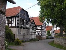
In addition to the 18 partly exemplary restored village churches, the Schmitt brewery , Ehrenstein Castle , the Dienstedt karst cave , the Kleinhettstedt mustard mill , the saltworks near Dörnfeld, the Singer Berg with its special flora and fauna, the Niederwillingen tunnel museum , the Großliebringen moated castle , the Oberwillinger Spring and numerous half-timbered farmsteads in Großhettstedt and Gösselborn.
A memorial stone on the main street of Nahwinden reminiscent of 57 concentration camp prisoners at a leading through the villages of the municipality death march of the Buchenwald concentration camp died in April 1945 and are buried in the cemeteries of the districts.
Economy and Infrastructure
The economy of the Ilmtal community was characterized by agriculture and cattle breeding. There is practically no industry, so most people are commuters and work in Stadtilm, for example. There are some salt pans near Dörnfeld that used to mine salt . Today they are accessible as a technical monument.
traffic
The most important traffic artery of the community was the federal road 87 Ilmenau - Weimar , which essentially follows the course of the Ilm. The closest motorway junction to the A 71 motorway is Stadtilm . The federal road 90 leads to Rudolstadt . Other roads lead to Arnstadt, Rottenbach , Remda , Gräfinau-Angstedt and the towns of the upper Wipfratals.
The districts of Niederwillingen and Singen have stops on the Arnstadt – Saalfeld railway line .
The Ilm Valley Cycle Path also runs through the municipality along the Ilm .
Individual evidence
- ↑ a b Thuringian Law and Ordinance Gazette No. 7 2018 of July 5, 2018 , accessed on July 6, 2018
- ↑ Website of the municipality -Ilmtal in numbers , accessed on April 17, 2018
- ^ StBA: Changes in the municipalities in Germany, see 1996


