Local winds
|
Local winds
City Stadtilm
Coordinates: 50 ° 45 ′ 10 ″ N , 11 ° 9 ′ 3 ″ E
|
|
|---|---|
| Height : | 428 (425-440) m |
| Residents : | 130 |
| Incorporation : | June 1, 1996 |
| Incorporated into: | Ilm Valley |
| Postal code : | 99326 |
| Area code : | 03629 |
|
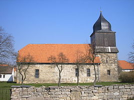
Village church
|
|
Close wind is a district of the town Stadtilm in the Ilm district in Thuringia with about 130 inhabitants.
geography
Local winds are located on a plateau on the Deube about six kilometers southeast of Stadtilm at an altitude of about 430 meters on the Ilm-Saale-Platte (shell limestone). To the east of near winds is the 461 meter high Galgenberg, over which the watershed between Ilm in the west and Saale in the east lies. Neighboring places are Ehrenstein in the east, Kleinliehaben in the southwest, Großliehaben in the west and Döllstedt in the north.
history
Local winds were first mentioned in a document in 1106. According to archival documents, no secular manorial rule could be proven. A document No. 1457 (Dorbencker) from March 1143 states that the place belonged to the Peterskloster in Erfurt and from 1106 a property to the Paulinzella monastery . So there were two church corpses. The village church Nahwinde probably originated in the 12th century from a chapel belonging to a church frong. The land of the serfs belonged to the monastery until the dissolution of the Paulinzella monastery and then the lands and real estate fell to the sovereign, who then enfeoffed the farmers. New manors could not be proven. Until the founding of the LPG, farmers worked in the village. Now they work in an agricultural association.
Close wind belonged to Schwarzburg-Rudolstadt ( suzerainty ) until 1920 , then to the district of Arnstadt , between 1952 and 1994 to the district of Arnstadt and since then to the Ilm district. On June 1, 1996, the place was incorporated into the new Ilmtal municipality. This in turn was incorporated into Stadtilm on July 6, 2018.
Economy and Infrastructure
Local winds are an agricultural place. The road from Stadtilm leads through the village via federal highway 90 to Rudolstadt . Other roads lead to Großliehaben and Remda (via Ehrenstein).
Individual evidence
- ↑ Wolfgang Kahl: First mention of Thuringian cities and villages until 1300 A manual - Verlag Rockstuhl 2nd verb. Edition - Bad Langensalza 2001
- ↑ Hörnlein, R. At that time - history and stories 900 years Deube 2005 harfe - print media Bad Blankenburg
- ^ StBA: Changes in the municipalities in Germany, see 1996
- ↑ Thuringian Law and Ordinance Gazette No. 7 2018 of July 5, 2018 , accessed on July 6, 2018
