Ehrenstein (Stadtilm)
|
Ehrenstein
City Stadtilm
Coordinates: 50 ° 45 ′ 23 " N , 11 ° 10 ′ 34" E
|
|
|---|---|
| Height : | 381 (380-400) m |
| Residents : | 150 |
| Incorporation : | June 1, 1996 |
| Incorporated into: | Ilm Valley |
| Postal code : | 99326 |
| Area code : | 03629 |
Ehrenstein is a district of the city of Stadtilm in the Ilm district ( Thuringia ) with about 150 inhabitants. The place is known for its medieval castle ruins, Ehrenstein Castle above the town center.
geography
Ehrenstein belonged to the community of Ilm Valley, but is not in the Ilm valley and not in its catchment area, as the watershed between Ilm in the west and Saale in the east runs about one kilometer west of the village . Ehrenstein lies in the valley of the Altremdner Bach , which flows east into the neighboring town of Remda . The geological formation on which Ehrenstein lies is the Ilm-Saale-Platte , an arid, karstified shell limestone massif. The place is about 380 meters above sea level, to the north the terrain rises steeply to the 547 meter high Großer Kalmberg , while to the southeast is the 468 meter high Buchenberg with the castle and to the southwest the 461 meter high Galgenberg. The area is characterized by agricultural land and wooded mountain tops.
Schönefeld is a plateau south of the villages of Ehrenstein and Sundremda . On this once barren area there were only bustards and hares. There have long been no bustards and hardly any hares left.
Geological feature
The Deube rises on the 461 meter high Galgenberg near Ehrenstein. Below Geilsdorf, the river seeps into the karst subsoil. Its water does not flow into the Ilm , but reappears in the Remda area about ten kilometers to the east and flows from there into the Saale .
history
The village was first mentioned in documents in 1217 or 1274, at that time still under the name Teichmannsdorf , which was 800 meters from today's Ehrenstein. Assumptions and archaeological finds prove that the inhabitants of the Teichmannsdorf left their place of residence and life and settled below the castle. The name of the castle was thus carried over to the settlement itself.
Ehrenstein castle and settlement have appeared since the 14th century as the center of a rulership of the same name, the Ehrenstein office , to which in 1378 the villages of Groß- and Kleinliehaben, Nahlösungen, Kleinhettstedt and Dienstedt belonged. In 1356 Ehrenstein was granted market rights, so that the Count of Schwarzburg-Blankenburg , to whom Ehrenstein belonged at the time, was allowed to hold markets. However, trade developed only slowly, as Stadtilm and Remda, two more conveniently located cities, were in the immediate vicinity of Ehrenstein. Thus, Ehrenstein remained a farming village over the centuries, although there are two old converted squares in the village - upper and lower village square - which show the beginnings of a (failed) market settlement, which distinguishes Ehrenstein from the other small villages in the area, which are known as simple street (e.g. local winds or Döllstedt) or disordered clustered villages (e.g. Sundremda) are laid out. Until 1920 it belonged to the sovereignty of the Principality or Free State of Schwarzburg-Rudolstadt (Amt Stadtilm), after which the state of Thuringia and the district of Arnstadt , to which Ehrenstein belonged, were founded. In 1996 Ehrenstein became part of the newly founded community of Ilmtal . This in turn was incorporated into Stadtilm on July 6, 2018.
Goethe stayed in the village in August 1777 and drew the castle ruins.
At the end of the Second World War, Ehrenstein became a theater of war. In mid-April 1945, German troops started their retreat from the Americans via Ehrenstein towards Sundremda in the east. A German artillery unit took up position there to repel American troops. The village was thus between the fronts. The civilians sought protection in the rock cellar of the Burgberg massif. Fighter bombers attacked the village. In the end, the Americans took control of the village.
Culture
Attractions
Ehrenstein Castle is located above the village and is now a largely preserved ruin with a keep visible from afar.
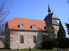
The village's Protestant church, the Ehrenstein village church , is a choir tower church from the 13th century, which was later rebuilt several times.
Memorials
A memorial in the cemetery commemorates the fallen soldiers (and some civilians) from the First and Second World War from the village of Ehrenstein.
societies
The volunteer fire brigade association and the rural women association invite you to social life.
Economy and Transport
Ehrenstein is an agricultural village. There is a riding stables and two family farms in the village .
Roads connect Ehrenstein with local winds in the west, Altremda and Remda in the east and Sundremda in the southeast.
literature
- HE Müllerott: Archaeological, historical and natural history hike around the Singer Berg ... Thüringer Chronik-Verlag, Arnstadt 1996, ISBN 3-910132-30-8 , p. 47.
Individual evidence
- ^ A. Witschel: Legends, manners and customs from Thuringia. Vienna 1878, quoted by HE Müllerott in sagas, fables and romantic stories from the central Thuringian Forest and its foreland. Thüringer Chronik-Verlag Arnstadt, 1995/1996, ISBN 3-910132-54-5 , pp. 211/212.
- ^ Wolfgang Kahl : First mention of Thuringian cities and villages up to 1300 - a manual. Rockstuhl Publishing House, Bad Langensalza 2001.
- ↑ Community homepage
- ^ StBA: Changes in the municipalities in Germany, see 1996
- ↑ Thuringian Law and Ordinance Gazette No. 7 2018 of July 5, 2018 , accessed on July 6, 2018
- ↑ Steinhaußen: In Goethe's footsteps in Rudolstadt and the surrounding area. 1998.

