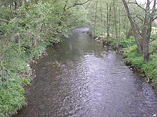
Dörnfeld on the Ilm
|
Dörnfeld on the Ilm
City Stadtilm
Coordinates: 50 ° 44 ′ 3 ″ N , 11 ° 2 ′ 7 ″ E
|
||
|---|---|---|
| Height : | 389 m above sea level NN | |
| Residents : | 180 | |
| Incorporation : | April 6, 1994 | |
| Incorporated into: | Singerberg | |
| Postal code : | 99326 | |
| Area code : | 03629 | |
|
Location of Dörnfeld an der Ilm in Thuringia |
||
Dörnfeld an der Ilm is a district of the town of Stadtilm in the Ilm district ( Thuringia ) with around 180 inhabitants.
geography
Dörnfeld is about 390 meters above sea level on the Ilm . The 583 meter high Singer Berg rises to the east of the village . Dörnfeld is a heaped village . It lies between the Thuringian Basin in the north, Saale-Ilm-Platte in the east and Thuringian Forest in the south.
history
Dörnfeld was first mentioned on October 28, 1285. The square island of 26 × 26 m in the pond on the outskirts carried a high medieval island castle next to a farm yard. It could have been the castle of the Lords of Dornevelt, mentioned in 1289.
The neo-Gothic church dates from 1902 and was replaced by the old village church .
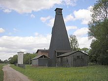
From the beginning of the 20th century until 1999, salt was mined in Dörnfeld. The saline towers are still preserved and are under monument protection . Until 1920, the place was part of the Stadtilm district in the sovereignty of the Principality and Free State of Schwarzburg-Rudolstadt . From 1920 to 1952 he was part of the Arnstadt district . The district was divided in 1952 and Dörnfeld was henceforth in the smaller district of Arnstadt . In 1994 the Ilmenau and Arnstadt districts were reunited under the name Ilm District. Dörnfeld merged on April 6, 1994 with other places in the area to form the municipality of Singerberg , which merged into the Ilmtal municipality on June 1, 1996 . This in turn was incorporated into Stadtilm on July 6, 2018.
The village was in GDR times a pioneer - camps , where children their holiday weeks spent.
Economy and Transport
Like the other places in the municipality, Dörnfeld is characterized by agriculture. There is an exceptionally mild climate on the southwest slope of the Singer Berg, which also enables the cultivation of special crops.
From Dörnfeld, roads lead to Singen and Cottendorf .
Until 2005 Dörnfeld was the seat of the regular school of the Ilmtal municipality. At the beginning of the 2005/06 school year they merged with the regular schools Stadtilm and Osthausen to form a joint school based in Stadtilm.
leisure
Dörnfeld is located on the Ilmtal cycle path . From here you can easily go on hikes to the Singer Berg . The place has a riding stable and a school camp , which is about a kilometer south of the place directly on the Ilm . In the Dörnfeld area there are still two protected salt pans . They are painted black and up to 15 meters high.
Many Dörnfelder are members of one of the five local associations that make an important contribution to cultural life.
Individual evidence
- ^ Wolfgang Kahl : First mention of Thuringian towns and villages. Rockstuhl Verlag, Bad Langensalza, 2010, ISBN 978-3-86777-202-0 , p. 59.
- ↑ Rudolf Fischer: Place names of the districts of Arnstadt and Ilmenau (German-Slavic research on onomatology and settlement history, No. 1) . Niemeyer, Halle (Saale) 1956, p. 23
- ↑ Hansjürgen Müllerott (Ed.): Archaeological, historical and natural history walks around the Singer Berg . Thuringian Chronicle Publishing House HE Müllerott, Arnstadt 1996
- ↑ Municipalities 1994 and their changes since January 1, 1948 in the new federal states , Metzler-Poeschel publishing house, Stuttgart, 1995, ISBN 3-8246-0321-7 , publisher: Federal Statistical Office
- ^ StBA: Changes in the municipalities in Germany, see 1996
- ↑ Thuringian Law and Ordinance Gazette No. 7 2018 of July 5, 2018 , accessed on July 6, 2018
- ↑ Facebook entry


