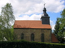
Cottendorf
|
Cottendorf
City Stadtilm
Coordinates: 50 ° 44 ′ 12 ″ N , 11 ° 1 ′ 42 ″ E
|
|
|---|---|
| Height : | 388 m |
| Residents : | 99 |
| Incorporation : | March 6, 1969 |
| Incorporated into: | Dörnfeld on the Ilm |
| Postal code : | 99326 |
| Area code : | 03629 |
Cottendorf is a district of the town of Stadtilm in the Ilm district ( Thuringia ) with around 100 inhabitants.
geography
Cottendorf is located in the Ilm valley at the confluence of the seven kilometer long Humbach . The surroundings of Cottendorf are flat and arable land in the north, while in the south they consist of hilly heathland . The predominant type of rock is shell limestone . 400 meters east of Cottendorf, on the other side of the Ilm, is the village of Dörnfeld an der Ilm .
history
Cottendorf was first mentioned on March 20, 1143. Until 1920, the place was part of the Stadtilm district in the sovereignty of the Principality and Free State of Schwarzburg-Rudolstadt . From 1920 to 1952 he was part of the Arnstadt district . The district was divided in 1952 and Cottendorf was henceforth in the smaller district of Arnstadt. On March 6, 1969, the place was incorporated into the municipality of Dörnfeld an der Ilm . In 1994 the Ilmenau and Arnstadt districts were reunited under the name Ilm District. Dörnfeld (with Cottendorf) merged on April 6, 1994 with other places in the area to form the municipality of Singerberg , which became part of the Ilmtal municipality on June 1, 1996 . This in turn was incorporated into Stadtilm on July 6, 2018.
There were several limestone quarries near Cottendorf in the 19th century.
Culture and sights
The cultural life of the place is shaped by the four Cottendorfer associations. The St. Catherine Church and an Evangelical Lutheran parish belong to the place .
The Freizeitheim an der Ilm is located away from traffic, between the towns of Gräfinau-Angstedt, Cottendorf and Stadtilm.
Economy and Transport
Cottendorf is an agricultural place.
From Cottendorf roads lead to Gräfinau-Angstedt , Dörnfeld an der Ilm and to the B 87 at Cottendorfer Kreuz .
The Ilmtal cycle path leads through Cottendorf.
Web links
Individual evidence
- ↑ Website of the municipality -Ilmtal in numbers , accessed on April 17, 2018
- ↑ Peter Acht (arr.): The documents since d. Death of Archbishop Adalbert I (1137) until z. Death of Archbishop Konrad (1200) . In: Historical Association for Hesse (Ed.): Mainzer Urkundenbuch . Volume II-2 (1176-1200). Darmstadt 1971. (38).
- ↑ Municipalities 1994 and their changes since January 1, 1948 in the new federal states , Metzler-Poeschel publishing house, Stuttgart, 1995, ISBN 3-8246-0321-7 , publisher: Federal Statistical Office
- ^ StBA: Changes in the municipalities in Germany, see 1996
- ↑ Thuringian Law and Ordinance Gazette No. 7 2018 of July 5, 2018 , accessed on July 6, 2018
