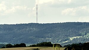
Great Kalmberg
| Great Kalmberg | ||
|---|---|---|
| height | 547.5 m above sea level NHN | |
| location | Thuringia , Germany | |
| Mountains | Ilm-Saale-Platte | |
| Dominance | 10 km → Singer Berg | |
| Notch height | 142 m ↓ saddle between Döllstedt and Ehrenstein | |
| Coordinates | 50 ° 46 '25 " N , 11 ° 10' 56" E | |
|
|
||
| rock | Shell limestone | |
The Great Kalmberg east of Stadtilm is 547.5 m above sea level. NHN high mountain in Thuringia . Apart from the Zeugenberg Singener Berg , it is the highest point on the Ilm-Saale-Platte .
location
The Große Kalmberg is located about 25 kilometers south of Erfurt and Weimar and belongs both topographically and geologically to the Ilm-Saale plate, which consists of shell limestone . The Großer Kalmberg lies on the border between the Ilm district and the Saalfeld-Rudolstadt district . Its western part belongs to the city of Stadtilm (Ilm district), while the eastern part belongs to the city of Rudolstadt . Places on the Großer Kalmberg are Dienstedt , Kleinhettstedt and Oesteröda in the north, Döllstedt , Nahe winds and Ehrenstein in the southwest and Altremda , Remda and Breitenheerda in the east.
The Große Kalmberg is covered with pine trees, its south side drops steeply to the Remdaer Graben , while in the north it slopes gently to the Ilm valley. The Kleine Kalm is a peak southwest of the summit at a height of 511 meters, while the Kleine Kalmberg is north and is 467 meters high.
use
In the years of the GDR , the anti - aircraft missile division 514 of the NVA with a helicopter landing pad was stationed on the mountain . After the German reunification , the military use would end. Parts of the former NVA site were converted into the Remda transmitter of the MDR with a 188 meter high transmitter mast . Other parts, especially on the southern slope of the mountain, were designated as FFH areas in 1999 on a total area of 264 hectares . This expresses the need for protection of the landscape, in which there are partially open and species-rich limestone slopes with dry grass, rocks and rock corridors as well as small moor and wet biotopes and whistle grass meadows .


