Ilm-Saale-Platte
| Ilm-Saale-Platte | ||
|---|---|---|
| Highest peak | Großer Kalmberg ( 548 m above sea level ) | |
|
|
||
| Coordinates | 50 ° 50 ′ N , 11 ° 12 ′ E | |
| rock | Shell limestone | |
| surface | 670 km² | |
| particularities | Depending on the demarcation, the Singer Berg (583 m) can also be seen as the highest elevation. | |
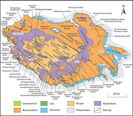
The Ilm-Saale plate (also Saale-Ilm-plate is referred to) a southeastern part-edge panel Thuringian basin in Thuringia , after the relief of an intersected by valleys limestone - plateau represents. It is located in its central part between the Ilm below the Ilm valley and the Saale from the entrance into the city of Rudolstadt . It is divided into the Ilm-Saale Platte in the narrower sense in the south (southwest) and the Jenaer Scholle , which joins the Weimar - Magdala - Rothenstein line north-northeast .
The article here is limited to the southern part, which extends to the left of the Ilm to Erfurt . In contrast, the Jenaer Scholle in Jena is broken through by the Saale.
expansion
Between the Wipfra in the southwest, the city of Erfurt in the northwest, Weimar in the north, the Magdalaer Graben , extended by the A4 and the Leutra in the northeast, the Middle Saale valley of the Saale between Rothenstein and Rudolstadt in the southeast and the Paulinzellaer Vorland or the Eichenberg– Gotha – Saalfelder fault zone in the western south, the area of the Ilm-Saale-Platte (without Jenaer Scholle) is about 890 km². Of this, around 670 km² are accounted for by the actual Muschelkalk plateau, around 80 km² by the central red sandstone depression of the Tannroda woodland and about 140 km² by the red sandstone slope towards the Saale in the southeast.
Counties and cities
The area of the Ilm-Saale-Platte has shares in the districts of Ilm-Kreis in the southwest, Saalfeld-Rudolstadt in the southeast, Saale-Holzland-Kreis in the northeast and Weimarer Land in the north. In the northwest it hits the independent city of Erfurt , in the north Weimar ; the urban area of Jenas is only marginally affected in the far east. Other, non-independent cities in the outskirts are Magdala in the northeast, Rudolstadt in the southeast and Stadtilm in the southeast.
Cities in the interior of the landscape are Blankenhain east of the center on the main plateau and Kranichfeld and Bad Berka centrally on the Ilm , on the edge of the Tannrodaer Waldland.
Natural allocation

The island-like Tannrodaer woodland and the Keupersenke of the Magdalaer Graben in the northeast are clearly recognizable.
The Ilm-Saale-Platte (in the narrower sense) represents the central part of the natural spatial shell limestone main unit Ilm-Saale- and Ohrdrufer Platte (474) within the main unit group Thuringian Basin (with edge slabs) (47/48). It becomes north-northeast continued by the Jenaer Scholle , which can be counted as part of the Ilm-Saale-Platte in the broader sense . In the south-west, the Reinsberge join the Ohrdrufer Platte .
The Tannrodaer Waldland as a central depression and the south-eastern slope to the Saale, on each of which there is red sandstone , are clearly differentiated from the actual plate geologically and scenically . The structure that only exists within Thuringia, The Thuringian Natural Spaces of the Thuringian State Institute for Environment and Geology (TLUG), which is not categorized into main and sub-units, but primarily according to the rock, divides the Tannrodaer Waldland accordingly as its own natural area and arranges the south-east roofing in the The main thing is that the Saale sandstone slab is to the right of the Saale .
landscape
The limestone plateaus, which are poor in water, are characterized by limestone flora. They are especially wooded at the strata to the red sandstone , which slope down steeply , especially at the seams to the Tannrodaer Waldland .
Surveys
Orographically , the Ilm or the strata to the Tannrodaer Waldland separates a western part, while the stratum to the south-east roof represents a further, not quite so distinctive threshold.
The following elevations in the shell limestone are worth mentioning:
|
Western part
|
Central part
|
Individual evidence
- ↑ a b c The mapping 1: 1,000,000 in the manual does not allow a clear assignment of the Singer and Willinger Berg to one of the two main units Ilm-Saale- and Ohrdrufer Platte and Paulinzellaer Vorland ; Both lie on the other side of the Eichenberg – Gotha – Saalfeld fault zone and are witness mountains of the Ilm-Saale-Platte, which do not belong to the core plateau; they continue the southeastern foothills of the Reinsberge and are each surrounded by red sandstone. In the 6th edition of the manual, the Große Kalmberg is referred to as the highest mountain in the Ilm-Saale-Platte, but the Singer Berg is not listed either in the Paulinzellaer Vorland or in the Ohrdrufer Platte / the Reinsbergen.
- ↑ Measurement via geopaths ( becken-grob.kmz KMZ ( page no longer available , search in web archives ) Info: The link was automatically marked as defective. Please check the link according to the instructions and then remove this note. , 170 kB)
- ^ E. Meynen and J. Schmithüsen : Handbook of the natural spatial structure of Germany - Federal Institute for Regional Studies, Remagen / Bad Godesberg 1953-1962 (9 deliveries in 8 books, updated map 1: 1,000,000 with main units 1960)
-
^ Walter Hiekel, Frank Fritzlar, Andreas Nöllert and Werner Westhus: The natural spaces of Thuringia . Ed .: Thuringian State Institute for Environment and Geology (TLUG), Thuringian Ministry for Agriculture, Nature Conservation and Environment . 2004, ISSN 0863-2448 . → Natural area map of Thuringia (TLUG) - PDF; 260 kB → Maps by district (TLUG)
- ↑ Map services of the Federal Agency for Nature Conservation ( information )
