Kaitsch
| Kaitsch (Kötsch) | ||
|---|---|---|
| height | 497.3 m above sea level NHN | |
| location | Thuringia , Germany | |
| Mountains | Ilm-Saale-Platte | |
| Dominance | 9.8 km → Spaal | |
| Coordinates | 50 ° 53 '35 " N , 11 ° 21' 54" E | |
|
|
||
| rock | Shell limestone | |
| particularities | Carolinenturm ( AT ) | |
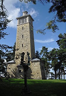
The Kaitsch or Kötsch is 497.3 m above sea level. NHN high Muschelkalk mountain in the Weimarer Land district in central Thuringia . At 497 m, the Kötsch is the second highest point in the Weimarer Land district . The border between the Blankenhain and Kiliansroda districts runs directly over the summit. The Carolinenturm observation tower, 26 m high, stands on a plateau .
location
The mountain is located in the north of the Ilm-Saale-Platte (in the narrower sense), near the northeastern interface to the Jenaer Scholle , and rises about 15 km south of Weimar and west of Jena . It is located in the city triangle of Bad Berka , Magdala and Blankenhain . To the west of the Kaitsch is the village of Saalborn , to the south the town of Blankenhain, to the east of Großlohma and to the north of Mechelroda .
One of the highest mountains in its area, its massif breaks off steeply to the northwest to the Ilm valley and to the southwest in a layered step to the red sandstone of the Tannrodaer Waldland . It only drops gradually to the southeast. If you climb the Carolinenturm, you will reach the highest point in the Weimarer Land district, while the height at the foot of the tower from Riechheimer Berg is 513.2 m above sea level. NN is exceeded.
The Kaitsch is forested ( mixed pine forest ).
Name and story
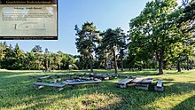
Linguists derive the name "Kötsch" or "Kaitsch" from the Slavic word "Katsch - forest". About a thousand years ago the area was a Germanic-Slavic border area. The Slavic residents also built the hill fort on the plateau, which served as a refuge for the surrounding settlements. The remains of the oval ring wall can still be seen today, in the southeast and east even as a double wall. In the middle there was a sacrificial site. A rusted battle ax and large animal bones were found during the excavation work for the foundation of the tower.
Carolinenturm
The Carolinenturm is a 26 m high observation tower that was built from sand-lime brick in 1909 in honor of Grand Duchess Caroline of Saxony-Weimar-Eisenach (1884–1905), who died early . When you have climbed the 106 steps to the viewing platform, you have a good view of Weimar, Kiliansroda , Mechelroda, Mellingen , the Thuringian Basin , and with good visibility as far as the Kyffhäuser and Harz Mountains . The chain of the Thuringian Forest can be seen in the south .
- history
Due to its exposed location, the Kötsch formed a main point in the first land survey of the Thuringian states in 1851. In 1888, a trigonometric point of the Guard Cavalry Brigade Potsdam was set for the Prussian land survey and a wooden observation tower was built above it. The tower was later converted into a lookout tower by the Thuringian Forest Association , but had to be demolished in 1904 because it was in disrepair.
In 1905 a tower building association was established to build a memorial tower in honor of the young and popular Grand Duchess Caroline of Saxony-Weimar-Eisenach, who died shortly before. The construction sum of 18,000 marks came together in national collections thanks to donations from associations and citizens. The stones for the construction of the tower come from the limestone quarry in Mechelroda. The foundation stone was laid on June 28, 1908, and the inauguration took place on November 7, 1909.
In the GDR era, abandoned to decay, the Kötschberggemeinde eV gradually renovated and redesigned the observation tower and the surrounding area from 1987 onwards. Windows and roof were renewed, the mountain plateau with lawns, seating areas, a playground and a knowledge path were upgraded for tourism.
literature
- Hartmut Stabe: Towers in the Grand Duchy of Saxony-Weimar-Eisenach. Discover, visit, hike. Weimar 2005, ISBN 3-930687-46-1
Web links
- http://www.carolinenturm.de/ , accessed on January 26, 2020
- Digital measurement of the Carolinenturm , accessed on January 26, 2020
- The Carolinenturm in the quattrocopter video , accessed on January 26, 2020
Individual evidence
- ↑ a b Map services of the Federal Agency for Nature Conservation ( information )
- ↑ [1]
- ↑ The Carolinenturm on the Kötsch at www.carolinenturm.de
- ↑ [2]
- ↑ [3]
- ↑ DNB 975291947


