Magdala
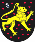
| coat of arms | Germany map | |
|---|---|---|

|
Coordinates: 50 ° 54 ' N , 11 ° 27' E |
|
| Basic data | ||
| State : | Thuringia | |
| County : | Weimar Country | |
| Management Community : | Mellingen | |
| Height : | 271 m above sea level NHN | |
| Area : | 20.58 km 2 | |
| Residents: | 2029 (Dec. 31, 2019) | |
| Population density : | 99 inhabitants per km 2 | |
| Postal code : | 99441 | |
| Area code : | 036454 | |
| License plate : | AP, APD | |
| Community key : | 16 0 71 053 | |
| LOCODE : | DE MGA | |
| City structure: | 4 districts | |
| Association administration address: | Karl-Alexander-Str. 134a 99441 Mellingen |
|
| Website : | ||
| Mayor : | Mario Hasskarl | |
| Location of the city of Magdala in the Weimarer Land district | ||
Magdala is a country town in central Thuringia between Weimar in the west and Jena in the east. It is located on the Magdel in the south of the Weimarer Land district and is part of the Mellingen administrative community . Districts are Göttern , Maina and Ottstedt .
geography
Magdala lies in the Magdalaer Graben , which divides the geological formation of the Ilm-Saale-Platte in the Hercynian direction, at a height of about 280 meters. The valley of the Magdel , a tributary of the Ilm, stretches along the trench from south to northwest . To the west lies the 496 meter high Kaitsch (Kötsch) and to the east the 422 meter high Coppanzer Berg . Weimar is about twelve kilometers northwest, Jena about ten kilometers east. The districts of Ottstedt and Maina are to the west of the city, Maina is already on the other side of the federal highway 4, while the village of Göttern is southeast of Magdala. Other neighboring towns are Kleinschwabhausen and Döbritschen in the northeast as well as to Blankenhain belonging Niedersynderstedt in the south. The desert corridor is located directly at today's city.
history
Magdala was first mentioned as Madaha in 874. Subsequently, the name changed via Madela (1184), Madela (1193), Madala (1203), Madla (1301), Madela (1345 and 1393) to Magdala.
The brothers Alexander and Dietrich von Magdala were vassals of the Counts of Orlamünde and sat in the Magdala moated castle . The castle was on the northeast corner of the old town in the valley of the Magdel. Later in 1395, but not until 1445, the Wettins exercised feudal sovereignty. In 1450 the city was partially destroyed and in 1452 the castle in the Saxon Civil War. Today only remains of the wall and the surrounding moat are left.
Around 1284 the place was given city rights by the Counts of Orlamünde . After the destruction in the Saxon Civil War, the city lost its importance.
Between 1535 and 1545 the city became Protestant.
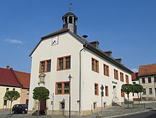
The town hall, a landmark of the town, dates back to 1571. The year is carved over the former entrance portal in the Renaissance style . The old foundation walls from 1570 indicate a building, the construction of which coincides with the founding of the city in 1288. In 1849 the town hall and parts of the city center burned down. The strong town hall walls remained, however, and give the new building erected in 1850 its current appearance.
A flood in 1613 killed many of Magdala's citizens.
The domain with 255 hectares was owned by the Grand Duchy of Saxony-Weimar-Eisenach . It was leased to Hubert Scheibe in 1923.
- Surname
There are no older documented mentions of the brook, they all deal with Magdala. The original name was probably Madel. A folk etymological derivation from maid would be conceivable . The original name is probably derived from the Old High German Madal (place of assembly), the Gothic maþel (market place), Anglo-Saxon mädhel (place of assembly) or the Middle High German mahel (people's court). A derivation from Old High German mad, math (mat, grassland) is also conceivable for the place. For the middle of the 19th century, however, the basic word aha (a variant of -au ) is proven. The name would therefore be court water or meadow water. Since a corresponding naming of the place seems unlikely, the brook is likely to give its name to the place, whose name was only later adapted to the name form of Migdal , Magdala , located on the Sea of Galilee , known from the Bible .
politics
City council and mayor
The municipal council election on May 26, 2019 resulted in the following composition of the municipal council:
| Party / list | Share of votes | Seats |
| CDU citizens' list | 42.4% | 5 |
| FDP - Free Citizens | 22.6% | 3 |
| Sports / youth / clubs | 34.9% | 4th |
Mario Haßkarl (CDU) has been mayor since 2004.
Town twinning
Attractions
Magdala has a small, irregularly laid out old town, which speaks against a planned city foundation. In the middle is the small market square on which the town hall stands. The two-storey building was built around 1571 in the Renaissance style and is crowned by a tower structure on the roof. A typical style portal has been preserved on the west side, above which a coat of arms stone is embedded.
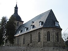
A little away from the market on a hill on the outskirts is the Protestant town church of St. Johannis , a Gothic hall church with a baroque tower dome typical of Thuringia. To the north of the old town in the Magdel Valley stood Magdala Castle, of which the foundation walls and a moat have been preserved.
- Memorials
A communal grave with a memorial stone in the cemetery commemorates six unknown prisoners on a death march from the Ohrdruf SIII subcamp of the Buchenwald concentration camp , who were murdered by SS men in the spring of 1945 . A similar memorial for five equally unknown and murdered prisoners was erected in the cemetery in the Göttern district .
traffic
Magdala is located directly on the federal motorway 4 , where it has its own junction (number 51). State roads connect the city with Weimar in the northwest, Bucha in the southeast, Isserstedt in the northeast and Blankenhain in the southwest.
The next train station is five kilometers north in Großschwabhausen on the Weimar – Jena – Gera line . This is served hourly by regional trains.
Personalities
- August Wilhelm Dennstedt (1776–1826), natural scientist, doctor and author. He was also mayor of Magdala and from 1818 scientific director of the Belvedere Botanical Garden in Weimar
- Horst Gerhardt (* 1935), mining engineer from Magdala, university professor and rector of the Freiberg mining academy
- Bernd Herzog (* 1938), soccer player from Magdala, played for Leipzig clubs in the GDR upper league
- Anton Sommer (1816–1888), poet from Rudolstadt , worked at times as a private tutor in Magdala
- Heinrich Friedrich Weber (1843–1912), physicist from Magdala, professor at ETH Zurich
literature
- Tilmann Ludwig: The Johanniskirche of Magdala , homepage of the parish Magdala / Bucha
Web links
Individual evidence
- ^ Population of the municipalities from the Thuringian State Office for Statistics ( help on this ).
- ↑ a b Elfriede Ulbricht: The river basin of the Thuringian Saale. A name-based investigation (= German-Slavic research on naming and settlement history . Volume 2 ). Max Niemeyer, 1957, ISSN 0070-3893 (also: Leipzig, University, dissertation, 1953).
- ↑ Michael Köhler: Thuringian castles and fortified prehistoric and early historical living spaces. Jenzig-Verlag Köhler, Jena 2001, ISBN 3-910141-43-9 , p. 179.
- ↑ Thomas Bienert: Medieval castles in Thuringia. 430 castles, castle ruins and fortifications. Wartberg Verlag, Gudensberg-Gleichen 2000, ISBN 3-86134-631-1 , p. 357.
- ↑ Information board at the town hall.
- ↑ Jürgen Gruhle: Black Book of Land Reform –Thuringia–. Retrieved June 25, 2011.
- ↑ Local council election 2019 in Thuringia - Magdala , accessed on July 29, 2019.


