Lehnstedt
| coat of arms | Germany map | |
|---|---|---|

|
Coordinates: 50 ° 56 ' N , 11 ° 26' E |
|
| Basic data | ||
| State : | Thuringia | |
| County : | Weimar Country | |
| Management Community : | Mellingen | |
| Height : | 280 m above sea level NHN | |
| Area : | 6.49 km 2 | |
| Residents: | 341 (Dec. 31, 2019) | |
| Population density : | 53 inhabitants per km 2 | |
| Postal code : | 99441 | |
| Area code : | 036453 | |
| License plate : | AP, APD | |
| Community key : | 16 0 71 049 | |
| Association administration address: | Karl-Alexander-Str. 134a 99441 Mellingen |
|
| Mayor : | Tobias Delle | |
| Location of the community Lehnstedt in the Weimarer Land district | ||
Lehnstedt is a municipality in the south of the Weimarer Land district and part of the Mellingen administrative community .
location
The agricultural village is located in the middle of the arable plain between Weimar and Apolda . The Weimar – Jena – Gera railway line touches the town's boundary to the south. The federal highway 7 opens up the rural area in terms of traffic.
history
Lehnstedt was first mentioned in the Ingelheim Protocol of 876 as a "Lautalahestat" because of the tithe dispute. In the Middle Ages, the place was owned by the Counts of Gleichen and the monasteries Kapellendorf , Oberweimar and Berka . There was destruction in the Thirty Years' War as well as by the floods of 1613 and 1830 and the major fires of 1665 and 1798. The plague raged in 1637 (96 dead). Gottlieb Friedrich Krause was born here on July 4, 1805, the son of a shopkeeper. He was the last servant of the poet prince Johann Wolfgang von Goethe (1749-1832). He died on November 9, 1860 in Ilmenau . He stood by Goethe's side from 1824 until his death on March 22, 1832. From 1815 the place was part of the Grand Duchy of Saxony-Weimar-Eisenach and after 1945 with the state of Thuringia became part of the Soviet zone of occupation and the GDR . On April 11, 1945, it was occupied by American troops. In 1952, as part of the GDR administrative reform, it became part of the newly formed Erfurt district . In the mid-1970s, Lehnstedt was connected to the drinking water network of the Erfurt district. Since 1990 the place belongs to the newly founded state of Thuringia .
Attractions
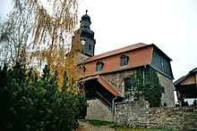
- Magdalenenkirche and rectory
- Wrought
- Memorial plaque for 16 unknown prisoners on a death march of the Buchenwald concentration camp , who were murdered by SS men after cruel torture
- Stone cross group on the eastern outskirts
Personalities
- Karl Heinrich Freyberg (1833–1909), teacher and cantor
literature
- Günther / Valtin: Chronicle of the community Lehnstedt, Weimar 1995. (Published on the occasion of the exhibition on the history of the village of Lehnstedt).
- Axel Marx: Family book Lehnstedt near Weimar (district Weimarer Land) Thuringia. 1588–1800 (= Central German local family books of the AMF. 80 = German local family books. 804, ISSN 2363-7528 ). Printed as a manuscript. Working Group for Central German Family Research, Leipzig 2014.
- Walter Schleif: Goethe's servant (= contributions to the German classical music. Abhandlungen. Vol. 17, ZDB -ID 503555-7 ). Aufbau-Verlag, Berlin et al. 1965.
- Gero von Wilpert : Goethe-Lexikon (= Kröner's pocket edition . Volume 407). Kröner, Stuttgart 1998, ISBN 3-520-40701-9 .
Individual evidence
- ^ Population of the municipalities from the Thuringian State Office for Statistics ( help on this ).


